
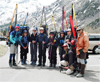
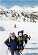
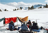
 Participants were Duncan Livingston from Oregon, Steve Stewart from Orangevale, Alvin Walter from San Diego, Susan Livingston, Jonathan Meagher, Leslie Hofherr, and Richard Geist from the LA area. The group was twice as large as on previous Trans-Sierras and surprises were to be expected. We met on Sun morning at the Rush Creek trailhead near Silver Lake. The arrangement was to leave the cars, ski across the Range, and be shuttled back by a hired driver with a large van from Bishop.
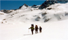
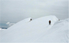
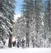
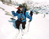 On Sun noon, 4/27, nine loaded skiers trudged up the dry Rush Creek trail toward Agnew Lake. Beyond the cable car we found solid snow and skinned up. We passed Agnew Lake and proceeded to Gem Lake, occasionally walking due to patchy snow. It was windy, overcast and snow flurries began to fall by early afternoon.
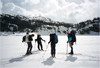 We passed Gem Lake at the north (right) side, lost the trail for a while, causing some of the group to ski across the lake, others to contour around it.
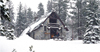
We all carried radios in case of separation. At the west end of the lake we regrouped and skied along the Rush Creek drainage toward Waugh Lake. The weather deteriorated and we looked for a suitable campsite. We camped in a snowed-in meadow surrounded by forest to be shielded from the winds, and with fresh water supply from a stream. We set up camp, cooked and ate while it was snowing. It snowed all night long.
We passed Gem Lake at the north (right) side, lost the trail for a while, causing some of the group to ski across the lake, others to contour around it.
We all carried radios in case of separation. At the west end of the lake we regrouped and skied along the Rush Creek drainage toward Waugh Lake. The weather deteriorated and we looked for a suitable campsite. We camped in a snowed-in meadow surrounded by forest to be shielded from the winds, and with fresh water supply from a stream. We set up camp, cooked and ate while it was snowing. It snowed all night long.
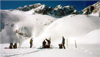
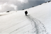
On Mon, 4/28, it was snowing while we got up. Due to the weather we had a late (10am) start. Breaking trail in the new snow was a workout, especially uphill. Most of us shared in this fun.
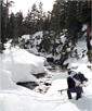 We crossed Rush Creek on a precarious snow bridge to follow ski tracks left by a descending group. Unfortunately, we soon reached their campsite, i.e., the end of their tracks. By midday we reached Waugh Lake and skied right across it in strong winds and heavy snowfall. We ascended the Rush creek drainage toward the Marie Lakes. As we got beyond the treeline, we were back in the wind, snow and occasional whiteout. When we reached the Lower Marie Lake it was time to quit. We found a flat, avalanche-safe campsite on the lake, but there was no wind shelter. We made camp, cooked and disappeared in the tents as soon as possible. The misery factor was particularly high for the three who had to set up a light, bottomless pyramid tent. The spindrifts would carry fine snow into any openings of a tent. At night gusts would rattle the tents. It was cold and snowed without break. It felt like a real winter storm.
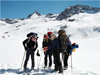
On Tue, 4/29, most of the sky was clear but it was still windy and cold. The Rodgers-Lyell Pass was in a whiteout. The pyramid-tent people had bad night; their sleeping bags were all covered by snow. The feeling was that this was not a pleasurable spring outing. Concern about avalanche danger was raised. Four of nine decided to return; five felt confident enough to proceed.
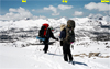
 Alvin, Steve, Duncan, Leslie and I signed out and proceeded as a private trip. Some equipment was shared and we took off. Mono Lake seagulls cruised high over the Sierra Crest as we ascended to the Upper Marie Lake. We spotted two cols, a steep one 0.3mi SE of Mt Lyell and a gentler one 0.3mi NNW of Rodgers Pk. Obviously we picked the latter, although the steepness on the west side turned out to be the reverse. We could ski all the way up to the 12,500' "Rodgers Pass", but on the steep west side we had to pack up our skis, kick steps and descend carefully with ice axes though mixed rock and snow. Eventually we could ski again.
 This traverse was probably the crux of the trip. Now we were in the headwaters of the Lyell Fork; a vast expanse of snow fields. We skied down a series of lakes (11,311', 10,999'). By afternoon the clouds had sunk down and we were eventually skiing in a complete whiteout. We used a Magellan Platinum GPS with built-in maps for navigation. When we reached Lake 10,702' 0.6mi W of Electra Peak we decided to quit and camp on the lake.
 In retrospect this was a good decision since without visibility we would have dropped down a steep cliff west of the lake. It snowed but luckily there was little wind. From kick stepping down the pass, the inner boots and socks were all wet. After a quick dinner we retired in our tents.
 On Wed, 4/30, we enjoyed to wake up to a cloudless sky. It was cold until the sun hit our tents.
By 9:15am we skied down the Lyell Fork to Lake 10,217', then climbed up a ridge west of beautiful Mt Ansel Adams , which we climbed the following summer. It brought us to a saddle on the north ridge of Foerster Peak, which was our "Pass of the Day". Luckily the Foerster ridge was not as badly corniced as so many other ridges were.
On Wed, 4/30, we enjoyed to wake up to a cloudless sky. It was cold until the sun hit our tents.
By 9:15am we skied down the Lyell Fork to Lake 10,217', then climbed up a ridge west of beautiful Mt Ansel Adams , which we climbed the following summer. It brought us to a saddle on the north ridge of Foerster Peak, which was our "Pass of the Day". Luckily the Foerster ridge was not as badly corniced as so many other ridges were.
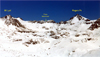
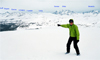
 The weather was great, the views fantastic. The entire eastern panorama of the Clark Range was visible. Alvin wanted to climb Foerster Pk but our tight schedule required us to push on. We contoured around the west side of Foerster, passed unnamed lakes (10,900', 10,300') until we reached Harriet Lake.
 There were fine ski runs down to the lakes. Impressive Long Mountain was to the east of us as we proceeded to Lake 10,217' 0.5mi N of Isberg Peak.
It was a delight to be back in the trees, out of the wind. By 4pm we located a fine campsite at Lake 10,217' and dug a 2' hole on the lake and found a supply of fresh water.
There were fine ski runs down to the lakes. Impressive Long Mountain was to the east of us as we proceeded to Lake 10,217' 0.5mi N of Isberg Peak.
It was a delight to be back in the trees, out of the wind. By 4pm we located a fine campsite at Lake 10,217' and dug a 2' hole on the lake and found a supply of fresh water.
 In the warm afternoon sun we dried out our moist clothes, sleeping bags, tents, reglued Leslie's skins, and enjoyed a relaxed happy hour and early dinner.
This was what we had hoped for the rest of the trip. But the fine weather was short-lived. At sunset a streak of high clouds produced a gorgeous red sky over the Clark Range. During the night high clouds covered the entire sky.
In the warm afternoon sun we dried out our moist clothes, sleeping bags, tents, reglued Leslie's skins, and enjoyed a relaxed happy hour and early dinner.
This was what we had hoped for the rest of the trip. But the fine weather was short-lived. At sunset a streak of high clouds produced a gorgeous red sky over the Clark Range. During the night high clouds covered the entire sky.
On Thur, Mayday, we were up at 6am and skied out by 8:15am, the earliest start so far. There was a reason: We had to get to Merced Pass before the next storm, predicted for Friday, would reach us.
 As we skied through the forested terrain Alvin spotted fresh bear tracks: Big paws that broke through the crust and two sets of little paws, which stayed on the surface. Obviously, Mama bear took a walk with her two cubs. We proceeded to ski toward Post Peak Pass but encountered a steep headwall with menacing cornices. Due to the avalanche danger we changed our route, skied back to the NW end of Turner Lake and ascended a gentler slope to a cornice-free ridge 1mi NE of Triple Divide Pk.
 High winds often precede a snowstorm; so we had a hunch of what was coming. We had a short lunch break hiding from the winds behind a large boulder. By now dark clouds were all around us. Ritter, Banner and the Minarets were beginning to be covered by clouds. It was time to move on. We contoured around a big bowl SE of Triple Divide but progress to the west was restricted by a south facing ridge full of cornices.
 We could not turn northwest to the saddle between Triple Divide and Merced. So we followed the ridge south and down, direction Walton Lake, until we found an opening in the cornices to ski across. From the ridge we saw another large cirque with a high point that looked like Merced Peak but just blocked the view of the real summit. In any case we had to proceed west over another ridge.
 The trip description called for an "obvious" pass on the ridge, which appeared to be high on the shoulder of the ridge. After we reached it we looked down a class 4 rock wall and found it impossible to pass. So we skied along the narrow crest down the ridge and searched for a possible descent route until we finally found one without cliffs.
By late afternoon skiing down the steep slopes was not to Leslie's liking. So we walked for a while, then skied the breakable crust in long traverses with kicksteps, until we reached the low lands at the South Fork of the Merced River. It looked inviting to stay among trees and an open stream on level ground. Thus, by 6pm we set up camp, just in time to settle down and eat before it started to snow. Although we had not made it to our planned destination, Merced Pass, we were glad to have crossed the Clark Range before the impending storm broke loose.
The trip description called for an "obvious" pass on the ridge, which appeared to be high on the shoulder of the ridge. After we reached it we looked down a class 4 rock wall and found it impossible to pass. So we skied along the narrow crest down the ridge and searched for a possible descent route until we finally found one without cliffs.
By late afternoon skiing down the steep slopes was not to Leslie's liking. So we walked for a while, then skied the breakable crust in long traverses with kicksteps, until we reached the low lands at the South Fork of the Merced River. It looked inviting to stay among trees and an open stream on level ground. Thus, by 6pm we set up camp, just in time to settle down and eat before it started to snow. Although we had not made it to our planned destination, Merced Pass, we were glad to have crossed the Clark Range before the impending storm broke loose.
Fri, 5/2, we got up at 5:30am, ate breakfast, packed and skied out at 7:30am. It was 2.5 mi in a straight line to Merced Pass. After we skied out of the forest on an open ridge we were greeted by high winds and snowfall.
 We traversed the ridge and dropped down into the sheltered forest. However, trailbreaking in deep snow took its toll and the constant ups and downs and turns around trees and stream crossings were rather time consuming. So we got back on the crest, faced the winterstorm with goggles and headed west, taking occasional breaks in the windshade of trees. The GPS guided us safely to Merced Pass where we had an early lunch. Then we ascended the Buena Vista Ridge to receive further punishment from gusts, snowfall and whiteout.
 From a previous SMS trip to the Clark Range I remembered the beautiful views of the Clark Range from the appropriately named "Buena Vista" ridge. Now the visibility ranged just to the end of the cornices from which we had to keep a respectable distance. In one area the ridge was covered with bare rocks and skiing became rather dicey, not to Leslie's liking. The afternoon went by and our destination, Ostrander Hut, was still many miles away. It became clear that we would not reach Badger Pass the next day. Thanks to R. J. lending us his cell phone, we could called the van company and asked them to pick us up one day later, on Sun at noon, at Badger Pass. All was agreed and we were set; so we thought. By 4:30pm we found a sheltered terrain in trees off the ridge at Buena Vista Pass and set up camp. Cooked while it snowed, ate in the tent, and went to bed asap. In the night it dumped a foot of wet snow on us.
Sat, 5/3, 6am, looked out of the tent and thought it is mid winter: Heavy snowfall, windy, snow-loaded trees, uniform gray skies. Tents and gear were covered by snow. Everything was moist. After digging out the cookset we prepared the usual oatmeal breakfast with tea. We packed our wet gear, which made the packs as heavy as on the first day and skied out by 8:30am. We skied along the ridge and almost made the same mistake as years ago, i.e., headed up Buena Vista Peak.
But we retraced our steps in time and enjoyed a wonderful powder run down to Buena Vista Lake, which we skied across. After crossing the saddle to the Horseshoe Ridge a yellow marker (#17, Merced Crest) was spotted, a first sign of "civilization". We skied up the Horseshoe Ridge only to find that it was heavily corniced. The usual descent at the east end of the ridge down to Heart Lake looked avalanche prone. The visibility was poor. So we decided to stay on top of the ridge and ski to its west end where we could descend on gentler, forested terrain and return to Ostrander Lake. We had a break in the weather and some welcome sunshine for an hour. Later we even got a glimpse of the Clark Range.
 Ostrander Hut was closed. After a short break we decided to continue. We skied along the Horizon Ridge route following the yellow markers. Beyond Horizon Peak one had to ski through slushy meadows, bushwhack and ski on logs across streams. As we descended the new snow turned into wet cement. By 6pm we reached the Glacier Pass Road, as well as Leslie's limits. Since there were no tracks on the road we camped on it. To compensate for all the wet gear we made a fire to warm and dry out. We shared the rest of the food and thought of next day's drive home. It again snowed 4"-8" during the night.
On Sun, 5/4, there were still lingering snow showers in the morning, but by 8am, as we left, the sun broke through. Our hopes for an easy glide down the road did not materialize. It was trailbreaking in heavy snow as usual. By 11am we reached Badger Pass, delighted to see car tracks on the road. Upon closer inspection, Badger Pass was deserted like a ghost town. Just a ranger may have driven through. Obviously the road was closed due to the recent storms. We had no options but to ski another 5 mi down to the Wawona Road, Hwy 41. Arriving by 12:30pm we met Steve's wife Becky and daughter Kelsey, but no van was waiting for us. Upon calling the company the word was the van had broken down and would not come. The "very sorry" response was no solution and we pressed for a replacement, obtained within an hour. Still we had to wait 7-8hrs for it to arrive, we thought. Becky and some kind people offered us a drive down into Yosemite Valley. We ate, showered and relaxed in Curry Village. We expected the van by 8pm, waited till 11pm when Curry Village closes. Then we rented a tent cabin to get some sleep and make alternate plans in the morning. At 6am the van driver finally showed up with a regular passenger car. We all squeezed in with our gear; the skis tied to the rackless roof. Then we went on a grand tour around the Sierras, which Duncan termed the best part of the Trans-Sierra trip. It was a delight to be driven through the green Sierra foothills, the white mountains south of Lake Tahoe and the rugged Eastern Sierras. Every few hours we had a food stop with lots of fun and laughter. Our driver Randy did a great job and safely covered the 800mi rt. with only 4 hrs of sleep. By 4pm we were back to where we had started, Silver Lake, and found our cars safely. After a farewell we headed home driving another few hundred miles north or south.
In retrospect, this Trans-Sierra trip was more demanding than any of my previous three; the
Classic High Route ,
the King's High Route and
the Cirque Crest High Route . Main factors were the two winter storms, a long distance (55mi), transportation problems, and the group breaking up (in hindsight better). Due to considerable avalanche conditions we were very careful and fortunately nobody got hurt. Although Steve developed a bad cough he hung in well. Our smaller group of five formed a great team. We had plenty of supplies and no serious equipment problems. In good weather the vast untouched ski terrain of the Ritter and Clark Ranges looked very impressive. With more time and better weather it would be a pleasure to climb and ski the many fine peaks in this remote backcountry.
Back to Trip Reports
Back to SMS Home Page