
We had scheduled an SMS trip to traverse the Tablelands from Silliman to Alta. There was strong interest in this trip until the weather forecast called for rain on the weekend, i.e., snow in the western Sierras. Everybody dropped out, so the trip was tabled. But what can one with a nice three-day weekend? Luckily, there is the desert which is often spared from the rain.
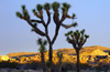
The SCMA had a climbing trip to Joshua Tree which Leslie Hofherr and I were invited to. But I had additional plans: I always wanted to traverse the "Wonderland of Rocks" in Joshua Tree.
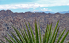
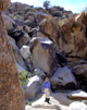
 It is an amazing landscape of boulders, washes, peaks and canyons. The interior region is true backcountry: No trails, no people, no water, and forbidden temperatures in summer. One has to explore this place in wintertime.
It is actually allowed to camp in this area but the park service indirectly discourages it by placing the hikers parking lot 2 miles away from the trailhead. For such a backcountry trip it is vital to bring enough water and to be experienced in navigation.
It is an amazing landscape of boulders, washes, peaks and canyons. The interior region is true backcountry: No trails, no people, no water, and forbidden temperatures in summer. One has to explore this place in wintertime.
It is actually allowed to camp in this area but the park service indirectly discourages it by placing the hikers parking lot 2 miles away from the trailhead. For such a backcountry trip it is vital to bring enough water and to be experienced in navigation.
On Sat morning we left LA, arrived 3 hrs later at J-Tree/Indian Cove, got our backcountry permit for the Boy Scout trailhead near the Ranger Station, and hitch-hiked 2 mi to the Rattlesnake Cyn trailhead (3000'). The goal was to climb Queen Mtn (5677') on the south side of the Wonderland.
 Since this is not done in an afternoon we would camp out somewhere, climb the peak next morning and then traverse the Wonderland via a different route back to Indian Cove. We were equipped with 1.5 gal of water each, a map and GPS, and camping gear. Near the entrance to Rattlesnake Cyn we turned southeast in the direction of Peak 5198'. First one steeply ascends a broad boulder gully, then climbs onto a long ridge, which eventually levels off to a large plateau.
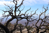
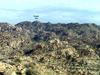
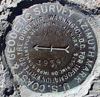
 The high point is Peak 5198' which had no summit register, until we left one. On the way one passes through a variety of terrain, bone dry-rocks, cactus country, and pinion pine forest. From the higher elevations we had a great view over the area: The Wonderland is an amazing terrain of random boulders, convoluted ridges, canyons, and washes.
 It was a significant distance away, involved a 400' drop and tricky navigation through canyon country. Since it became obvious that we could not reach it that day we descended toward a wash of two dry rivers running down NW from Queen. We camped above the wash near UTM 3768100N, 11580600E, elev 4800'. It was absolutely quiet in the canyon. At night the temperatures dropped below freezing.
On Sun, Feb 15, we started at daylight with a lighter pack.
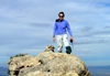
 We ascended the wash, climbed through pine country up a gully to between the two peaks of Queen Mtn (5482' and 5677'). Contouring around the south side we found an easy ascent to the higher summit from the SW. There was a fine peak register which we signed. We enjoyed the views, had a snack, took pictures and scouted a different route for the descent.
After returning to camp we packed up and continued down the wash, contouring N of Pk 5005' and S of Pk 4838'. We descended a dry streambed NW toward Willow Hole. There were occasional steep drop offs which we had to circumnavigate.
 We found a few puddles of water, some frozen, some thawed, mixed with green algeas. But the stream from Willow Hole carried a trickle of fresh water.
North of Pk 4015 we ascended a gully toward the upper Rattlesnake Cyn. Its north side had steep walls and we had to make some uphill detours to drop into the canyon. Climbing down Rattlesnake Cyn with full pack was our last act.
Then it was a boring 2mi hike to the car. After 9 hours of traversing the Wonderland of Rocks we needed a break. We drove to the town of Joshua Tree and joined the SCMA folks for a delicious Thai dinner. Next day we climbed with them.
We found a few puddles of water, some frozen, some thawed, mixed with green algeas. But the stream from Willow Hole carried a trickle of fresh water.
North of Pk 4015 we ascended a gully toward the upper Rattlesnake Cyn. Its north side had steep walls and we had to make some uphill detours to drop into the canyon. Climbing down Rattlesnake Cyn with full pack was our last act.
Then it was a boring 2mi hike to the car. After 9 hours of traversing the Wonderland of Rocks we needed a break. We drove to the town of Joshua Tree and joined the SCMA folks for a delicious Thai dinner. Next day we climbed with them.
P.S. The next year we did really make a Winter Traverse of the Tableland.
Back to Trip Reports
Back to SMS Home Page