


Writer's note: This story was written several months after the events while taking acclimatization breaks on the ascent up Mount Kilimanjaro in Africa and the facts are being revealed as best remembered.
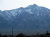
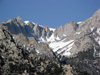
Among the classier Sierra Peaks, Mount Williamson ranks near the top for many. It is the 2nd highest mountain in the Sierra, and it is a unique, solo mass that stands out from the east escarpment, making it appear especially huge and challenging. From Highway 395, there are several distinct drainages and the one that leads most directly to the top is Bairs Creek.
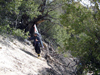
Scott Siegrist, Cedric Ma and Andy Lewicky planned to join me at 6:00 a.m. at the starting point for a 2 day round trip assault on the summit. As things turned out, Andy had commitments on Sunday and he went up a day early to do the "horns", close by the main peak. Fortunately, he provided me with some very valuable trip report information prior to his departure since there is no trail and the route is not obvious. Scott and Cedric were right on time and we began our ascent high on the north ridge of Bairs Creek with hopes of finding "the notch" without too much difficulty since it was essentially the gateway to our goal. It is very easy to overshoot or undershoot that key passageway and waste valuable time and energy as we had to gain over 8,000 vertical feet through miles of rugged, bushy, undulating, steep and unmarked terrain. Fortunately, there were 3 of us and we spread out enough to increase our odds of hitting the mark. The cliff bands that we had to get through didn't make things easy, as there were several locations that had the famous "notch" look. After closer inspection, we found it without loosing too much hard-gained elevation.
At the notch, our location was presently hundreds of feet above Bairs Creek and we had to set a traversing course across a steep scree slope to the bottom of Bairs without loosing any more elevation than we absolutely had to. That wasn't easy as trees, bushes, loose rock, more scree and at least one challenging 3rd to 4th class rock section stood in the way. With a substantial expenditure of time and energy, we gained the log jam crossing at the creek and began our ascent again, only to realize that in the last 2 hours we had covered a little over a mile and were now just getting back up to the elevation we were at the notch!
Just ahead of us was a fork in the drainage with that patch of evergreens in the right fork that Andy wrote about that survived the many avalanches that cleared all the surrounding area. Our direction was the left fork where we had seen snow from a perspective further back. A short way up that drainage, we were happy to find firm snow where we were able to put on the crampons and begin to make good vertical progress. Within half and hour, we came to a short waterfall -about 10 feet- and had to climb rocks again to get around it.
As soon as I got to the continuous ribbon of snow above the waterfall, there was Andy, skiing right toward me. We all enjoyed crossing paths right at that point, as we were able to exchange relevant information about conditions from both directions. Andy informed us that he summited one of the 'horns' and had decent skiing in the steep, upper chute with variable conditions below that. We informed Andy about the precipitous course we just took, then made constructive salutations to each other and were off in our respective directions. Crampons continued to work well for the next 45 minutes, then we were able to break out the skis and skins and slightly pick up the pace. I wanted to make it to 11,000 feet to put us in a good position for the summit attempt.
There were shallow suncups to begin with that progressed into 1 to 3 foot soft 'shark fins' as we headed toward a water source to top off all our water bottles. We had seen water pouring down a cliff from some distance off and figured that would be our easiest and best source since it was also at the elevation we were planning for camp and the remaining daylight was getting short. What we didn't foresee was that the water spilling down the cliff was hitting rocks near the bottom and splashing several feet out causing the immediate access snow to be frozen water-ice -- very hard to move or stand on-- and it was going to mean an ice-cold shower to get within reach of the flow that could be used to get the bottles filled. There was no alternative at this point and I had to don my rain parka and stand in the shower as Cedric and I exchanged empty, then full, bottles.
After the water gathering ordeal, we attempted to head back across the deep shark fins that had now frozen due to shadows we were in for the last hour and had to proceed with extreme caution toward the flatter-looking area where we planned to make camp. We were hoping to find some exposed gravel to camp on but wound up making due with a snow camp in an area of shallower sun cups. Cedric broke out his very efficient Jet Boil stove and we were able to have some hot drinks with dinner before retiring for the night.
Sunday morning we were up at 4 a.m. and, after some quick munchies, Scott and I were starting our crampon ascent up the hourglass couloir. Cedric's prime objective on this adventure was to ski the couloir that wasn't going to ripen until mid to late morning; so, he opted to catch some more sleep and head out later. The snow condition in the couloir was smooth and firm that would make for some great skiing later in the day. At the top of the couloir was a large snowfield that we were able to skin up to a distinct change in aspect where the continuous snow ended and we left our skis. Time was moving on rapidly for us, knowing what we would have to do to return, and yet we had come this far and an hour rock scramble to the summit was just too close not to do.
We found a relatively new register at the summit and made our entries expressing the exhilaration we were experiencing and the views we were enjoying. After taking numerous summit view photos, it was time to head down. Back at our skis after noon, I was concerned about the daylight time we had left to make it all the way back to our cars.
Finally, we were anticipating some of the fun skiing we came here for as we stepped into our bindings and buckled our boots. The gentle south-facing snowfield we started down had substantial sun cups that had softened in the sun, making linked turns challenging but very doable until we hit a flatter stretch at the bottom and made a straight run for the top of the couloir. This is where our huge climbing efforts paid off most as the 1 to 2 inches of corn on this smooth, steep base in the partially shaded east-facing couloir was what we were pumped for. To begin, I initiated 15 to 20 silky smooth turns right off the ridge to a point where I was able to stop and photo Scott carving a new track as he headed in my direction. Cedric was a short way below and caught both Scott and me on film as we swished by him. Some minor aspect changes, including entering and exiting the shaded area, made for quickened turns and accelerating speed. Scott and I headed to skier's left of the huge monolith that split the couloir into two and waited for Cedric as he worked a smooth line down next to the cliff band.
We regrouped at the significant change in snow texture from smooth and flat to mildly sun cupped. At this point, we enjoyed many more turns working small terrain features to make the best of the softened sun cups and in some cases runnels that were best avoided until we got back to our camp. I was very pleasantly surprised at the good time we were making. After repacking all our gear, we headed to the south side of the great cirque to take advantage of a slight northeast aspect that had smoother and more skiable snow that had been partially sheltered by the long shadows cast by the substantial height of the nearby terrain.
As we descended, the hard features sticking through the snow along with some of the ones just inches below the snow made for an intuitive approach to connecting the quilted areas of snow into one continuous line until we got down to about the 8,500 foot level where the snow was smooth and nicely consolidated into a narrow and moderately pitched ribbon. Skiing at this point was reduced to side-slipping to control the speed until we reached the point just above a small waterfall where we had crossed path with Andy on the way in. A short hike around the waterfall brought us to three more separate snowfield bands that had some nice terrain features permitting the last of our skiing down to about the 7,200 foot level to include numerous peddle hop and jump turns - a nice way to finish off the skiing section.
The creek crossing, bushes, loose rocks, exposed steep rocks, scree, and return route-finding through the sections that should most appropriately be named the Devil's Navel now confronted us. We were determined to find an alternate way around the steep rock section by staying above Bairs Creek on the south side for at least a few hundred yards beyond the obvious log jam crossing and paid a substantial price for doing so. Several aborted attempts to cross put the pressure on us to make the next attempt go to prevent getting too far down stream in terrain so steep and brush so thick that we would have been forced to spend valuable time and energy in a retreat. The choice we took tested our log-balancing skills while high above the creek in brush dense enough to make Brier Rabbit have second thoughts about being there. I vividly remember looking back as Cedric was trying to push through the thicket with his skis hung up in branches too thick to bend and thinking that the exposed rock section we avoided may not have been that bad after all.
With coaching tips between us and hard fought individual struggles, we broke into an opening and tried to find that ill-defined traverse back up to the right notch several hundred feet above us. Progress was slow as we had many false leads that we had to double back around then inch forward. After about 2 hours since leaving the snow, we reached the notch and for the most part knew that it was essentially downhill from there. The temptation on the east side of the notch is to follow the fall line straight down which must be resisted at all costs to avoid the steep sidewalls and impenetrable bush of lower Bairs Creek. After negotiating our way northeast to our undulating ridgeline, we knew we were on a homerun stretch back to our cars and that we would make it before the tall shadows were about to end another day. There was no big hurrah at our return, only a deep, personal satisfaction of having lived our dreams and knowing that in the company of kindred souls, much fun and great goals can be accomplished. Thanks to Scott, Cedric and Andy for sharing the fun.
|
|
|
|
|
|
|
|
|
|
|
|
|
|
|
|