
 If you want to get away from the summer heat, city life, club and park bureaucracies and be free in the mountains, here is a nice and easy trip to do:
I left L.A. on a Fri afternoon after work, joined the outgoing weekend traffic, passed through the hot Mojave desert and was 4 hours later near Lone Pine. Before getting into town I turned off on Lubken Canyon for a shortcut to the Cottonwood Lakes Road. The road climbs up to nearly 10,000' and suddenly you are in a cool fresh thin air.
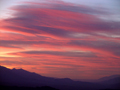
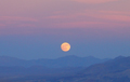
There was a beautiful sunset and a full moon rise over the desert. I spent the night at the hikers walk-in campground near the Horseshoe Meadows trailhead.
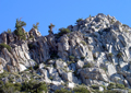
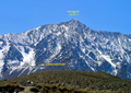
 On Sat morning I was up at 5am, had the standard oatmeal breakfast, got on the road and back to the Wanoga trailhead by 6am. It is located where the Little Cottonwood Creek crosses the road, prior to reaching the high point on the road. There is an inconspicuous trail on the south side of the creek. After a few hundred feet it crosses to the north side and follows along the creek. At a developed campsite I turned right (east) for an easy XC hike along a dry streambed to Wonoga. The ridge becomes soon visible and the destination is the right peak on the ridge. There are various options to climb it: A straight ascent through a chute below the summit, a detour to the left or the right. You know which one I took. It was a short cl 3 scramble.
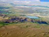
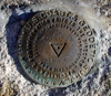
 At 7:15am I enjoyed the summit views from Wonoga. The entire Owens Valley is 6000 feet below you and starting to heat up on another fine summer day. A summit register was in a taped-up glass jar. This peak gets only a few visitors each year, but in 2006 there was a large party on the summit on occasion of the 50'th anniversary of the Sierra Peaks Section. It is always fun to see the same terrain in different seasons. Compare the view of Wanoga in winter 2008 from Owen's Valley.
After taking pictures and identifying some peaks I returned climbing down the southeast face, then heading back west to the creek and road. It was a nice morning hike.

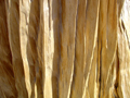 Then I drove up to the Horseshoe Mdw trailhead and hiked through the already brown meadow up to Trail Pass on the PCT, destination Trail Peak. Just north of the Pass I left the trail to hike XC up the ridge first through forest, then open rocky country toward Trail Pk. Nothing to brag about this hike, except for the views. And some pretty old trees, probably foxtails, whose wood was beautifully carved by wind, sun or other forces of nature. Looking at the in the shade of an old treetrunk one could see several colorful rings around the sun on a cloudless blue sky. This is supposedly due to light scattering from tiny waterdroplets at high altitude.
![]() Since there is no other higher peak far or near one has an unobstructed 360 degree view of the southern and middle Sierra Nevada. It was a cloudless summer day. The air was clear since a strong breeze blew from the west. There was an ammunition cannister with several spiral notebook registers in it. The peak is climbed frequently. Even two SMSrs were there, Lorene and Mike. Notable SPS seniors were there for a 50'th anniversary hike. After getting chilled out by the wind I proceeded northwest along the ridge, hiked down to the Poison Meadow Saddle where I picked up the PCT. It winds along the west side of the ridge. Met nobody, probably all thru hikers are already in Oregon in this year without winter.
Since there is no other higher peak far or near one has an unobstructed 360 degree view of the southern and middle Sierra Nevada. It was a cloudless summer day. The air was clear since a strong breeze blew from the west. There was an ammunition cannister with several spiral notebook registers in it. The peak is climbed frequently. Even two SMSrs were there, Lorene and Mike. Notable SPS seniors were there for a 50'th anniversary hike. After getting chilled out by the wind I proceeded northwest along the ridge, hiked down to the Poison Meadow Saddle where I picked up the PCT. It winds along the west side of the ridge. Met nobody, probably all thru hikers are already in Oregon in this year without winter.
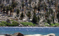
 After Cottonwood Pass I stopped at Chicken Spring Lake. It is a pretty place. The blue lake sparkled in the sunlight. At a sandy beach I took a dip into the refreshing water. More hikers came in to camp at the lake. By 5pm I returned via Cottonwood Pass and Horseshoe Mdw to the car. By now the weekend crowds had filled up all the campsites. So I decided to spend the next 4 hours listening to fine music in a cool car and be back home by 11pm. It ended a nice short excursion into the mountains.
Back to Trip Reports
Back to SMS Home Page