
The Wahoo Gullies are classic couloirs for ski mountaineers in the Eastern Sierra Nevada. They are located on Mt. Locke (12,634') southeast of Mt. Humphreys near Bishop.

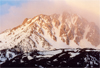 The central couloir leads to the summit. It is about 2500' long, at least 50' wide, and has an angle between 30 and 40 degrees. Our scheduled tour attracted 13 participants: Lisa Freundlich, Reed Moore, Alvin Walter, Jerry Olsen from San Diego, Duncan Livingston from Hemet, Felix Betschard, Stefano Villa, Keith Hines, Gregg Esser, Jim DeRose and myself from the Los Angeles area, John Bees from Reno and Greg Stach from San Francisco.
We met Saturday morning near the McGee Creek on the Buttermilk road and car shuttled in two four-wheel drive trucks to the road end (8,500') leaving by about 9 am.
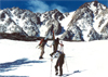
 After some hiking we reached the snow level, skinned up to the base of the central gully which, face on, looks somewhat intimidating. On the lower portion we could still ascend on skis but soon it was easier to kick steps. The gully is long! It took 2 hours to reach the ridge. The group was widely spread out in the gully.
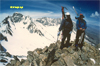 A few of us had some energy left and climbed to the summit of Mt. Locke. The scenery was great: Tom, Basin, Humphreys, Emerson were all nearby and they had inviting slopes waiting to be skied. Gregg, a professional sports photographer, took many scenic and action pictures.
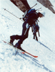
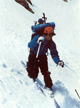 Then came the moment we had waited for. From the summit we made a few practice turns and then dropped into the steep upper Wahoo Gully (>40 degrees). The snow was tricky with a soft layer of variable thickness on a frozen base. Parallel jump turns were the rule, teleturns the exception. It was an exhilarating skiing experience: Flanked by high granite walls one skies down a relentlessly dropping chute, trying to avoid disastrous falls.
 We waited for the last ones and then skied down a new route which had snow coverage nearly to the cars. Shuttling in 4WD cars got us back to the remaining cars and then to a pretty car campsite near a stream in the Buttermilk country. It was party time. We sampled a variety of excellent dishes, good wines, and desserts. The happy hour continued around a campfire.
On Sunday, we originally planned to ski the nearby Basin Couloir. However, the snow level was too far above the dirt road and there was no enthusiasm for a long dry XC hike. Thus, we drove on the main road first toward North Lake which was also dry and then toward South Lake where we were lucky and could ski up from the road. We ascended the Northern end of the Inconsolable Range up to a 12,000' ridge East of South Lake. There was an excellent view of the Evolution Group to the West, Humphreys and Tom in the North, and the Palisades Range to the South. After an early lunch we skied down a Northeast facing slope with excellent spring snow to Brown Lake (10,800'). The descent continued via Bluff Lake to Parchers Camp (9,400') with some challenging forest skiing in soft snow. Although the group was widely scattered everyone made it eventually safely back to the cars. It was another fine ski tour. On the way home Duncan left some fine telemark tracks on the sanddunes in Red Rock Canyon.
Back to Trip Reports
Back to SMS Home Page