
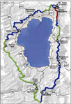
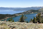
The TRT is a 165 mi long mountain trail with about 24,000 ft elevation change, thus mellower than the JMT (210 mi, 80,000 ft) but by no means a leisure trip. The trail goes through Alpine-like and desert-like terrains, involves travel on snow in early summer, route finding with GPS, some stream crossings, passes through forests and near beautiful lakes, past green meadows and slopes with beautiful wildflowers in early summer, and offers gorgeous views over Blue Lake Tahoe. On the eastern side of the Lake there are long stretches of no water. But where there is water, there are many hungry mosquitoes. The trail passes only through one town (Tahoe City) where I self resupplied. Since the trail is very popular and Lake Tahoe attracts many tourists you are rarely alone. You meet day hikers, section hikers, runners, mountain bikers and horse back riders. On the west side of the Lake the PCT and TRT share the same trail and you can meet some of the serious long-distance hikers. But in the early season there are also stretches where one finds solitude and a real wilderness experience. Every day brings new sceneries and encounters. Another nice feature is that the loop trail requires no car shuttle.
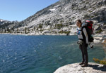
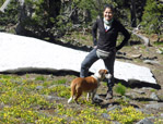
I started the hike at Echo Lake, since I remembered it from my previous hike on the PCT. It was a pleasure to be accompanied by my daughter Isabel who loves the outdoors as much as myself. But unlike an emeritus she had only a limited time and returned while I soloed the rest of the trip.
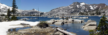
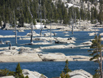
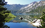
On Thur, 6/23 we started leisurely with a boat ride across Echo Lake. Then we three (counting her dog Timone) loaded up our backpacks and hiked into the Desolation Wilderness. We followed the joint PCT/TRT trail toward Lake Aloha. It is a spectacular sight of snow-covered mountains, rocky islands with barren trees, wind-swept water, and luckily an intense sun shine. We had lunch at the shores of the lake and took many pictures.
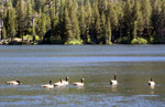
In the afternoon we continued to Heather Lake and Suzie Lake. There was a scenic campsite overlooking Suzie Lake which looked perfect for a campsite. A nearby creek supplied fresh water. Yes, there were mosquitoes, which is unavoidable in early summer near water, but it was manageable with lots of Deet.
On Fri, 6/24 we continued our hike toward Dicks Pass. Isa lightened her pack and left her camping gear since she would return the same way. We passed by Gilmore Lake and ascended toward Dicks Pass (9,380'). With increasing elevation the snow patches became more frequent. Timone loved the snow and ran in circles like a kid, until tired from the elevation. We stopped for lunch below the Pass with a fine view on Half Moon Lake below us and the snow-covered crest with Dicks Pk, Jacks Pk and Pyramid Pk. Then it was time for Isa to return while I would continue the thru-hike.
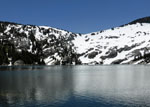
Dicks Pass is a bit deceptive. It is not the saddle seen from the south which becomes clear when one looks down from the saddle. It is a steep snow-covered slope ending in Dicks Lake, on which a fall would end the trip and probably the life. Wisely the trail continues along the crest until descending diagonally through wooded terrain. A GPS is helpful for route finding since the trail is covered by snow and tracks from previous hikers are often erroneous or not visible on frozen snow. Near Dicks Lake the excitement was over and the trail was easy to follow. Looking back over Dicks Lake the scenery appeared like on a ski mountaineering trip. The next lake, Fontanillis, was even more beautiful than Dicks Lake. Crystal clear water invited for a swim but the ice-cold water actually hurts after a short while.
My hike continued past the Velma Lakes where I took a short refreshing dip, then proceeded to Phipps Creek where I refilled drinking water. It was recommended to pump all water around the Lake Tahoe area. After another mile there was a fine waterfall next to the trail with a flat camping spot, which was too inviting to bypass since it was already 5 pm.
On Sat, 6/25 I got up at 5:30 am and was hiking at 6:15 am. I met young and old PCT hikers heading toward Canada. At Richardson Lake I had another refreshing dip. At Barker Pass a group of people had a food party and invited thru-hikers for refreshments and conversations. It refreshed my fond memories of trail angels on the PCT hike two years ago.
At Miller Creek I pumped water with my small Katadyn pump, when I noticed that the plastic kousing had cracked and the pump was shot. Well, I had iodine pills for a backup and now drank yellow-brown water. Near Twin Peaks the PCT and TRT split and I headed northeast direction of Tahoe City. Compared to the PCT there was no traffic on the TRT. Coming down the snow covered TRT trail, I found around 5 pm a clear campsite with view of the ridge of the Granite Chief Wilderness. This was a 17 mi day and I felt it.
On Sun, 6/26 I had an easy day hiking 10 mi down to Tahoe City where I would pick up a resupply parcel. On the way down I saw the McClouds Falls, crossd the Ward Creek, passed through the Ward Meadows filled with wildflowers, met several mountain bikers and runners, and finally arrived at the campground of the Tahoe State Recreation Area. I had to spent Sunday in town since the post office was closed. The afternoon was spent as a "nero", showering, eating, drinking, shopping and sightseeing. I even found a mountaineering shop and got a new waterpump. A sumptious dinner with live music at the Commons Beach ended an easy day.
On Mon, 6/27 I picked up my resupply parcel from the Post Officeat 8 am, repacked the food for 8 days and took off at 9 am with a heavy pack. From the Lake elevation (6,224') one climbs initially 1000' up before the trail levels off. The first destination was Watson Lake 12.4 mi ahead. Since the map showed two creeks crossing the trail beforehand I carried only one quart of water to lighten the heavy pack. Big mistake, since both creeks were dry and it turned into a very hot day. I reached Watson Lake dried out and overheated, jumped into the lake to cool off, pumped water into all containers and swore better to be overloaded than dehydrated. About a mile beyond the lake Watson creek crossed the trail and I decided to camp in its vicinity to refill next morning for another 15 mi dry stretch. It was an eventful day of about 14 miles. I met other TRT hikers, mountain bikers and runners. Occasionally there were fine views of Twin Peaks, Squaw Valley, Castle Peak and, of course, blue Lake Tahoe.
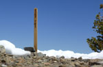
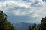
On day 5, Tue, 6/28, I was on the trail by 6:15 am when the air is cool and hardly anybody on the trail. Brookway Summit was the first destination which was reached by 10 am. It is one of 7 trailheads, typically involves a road crossing with fast car traffic. Another surprise was a tree cutting crew which cut a wide swath of trees to put in a new powerline. It was sad to see healthy 100-year old trees to be chopped down the sake of "progress". From Brookway Summit (7,199') the trail climbs continuously past Martis Peak (8,400'), Mt Baldy (9,271') and Rose Knob Peak (9,340'). On this clear day one could see Mt Lassen to the north.
There are two lakes below the trail, Gray Lake and Mud Lake. Due to the names I picked the former for a campsite. At this elevation travel over snow was the rule and it was not easy to find the lake. But the sound of frogs was a good guide. The lake had an inlet stream whose cold fresh water tasted wonderful. The lake was not deep enough for a swim but was still perfect for a refreshing clean up. Some time later another TRT hiker came down and we camped, talked and ate dinner together. I noticed that he was wearing mountaineering boots.
The next day, Wed, 6/29, I was again starting around 6 am while my younger friend preferred to sleep longer. I am sure he woud pass me soon since he was much faster than an overloaded senior. I passed by Mud Lake, Ginny Lake, climbed the switchbacks to Relais Peak (10,338') which is the highest point of the TRT. There was lots of snow on the trail, requiring some help from the GPS, and careful traversing of deep suncupped snow fields. Upon descending Relais Pk I met a gentleman with a light pack and asked him about his travel plans. He introduced himself as a TRTA leader who surveyed the trail conditions in this area.
 I could report to him what I found. We continued for a while with interesting conversations about the trail, the TRT activities, geography, climate, etc. Then our routes separated since I wanted to see the Galena Falls while he headed straight to Mt Rose trailhead.
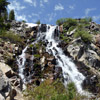
It was worth seeing the Galena Falls which were running strong during the snowmelt season. In fact part of the water emerged from a snow field at the top of the falls. It was a popular place for many visitors making a day hike from Hwy 431 at Mt Rose summit.
 I continued to the Mt Rose trailhead, looked at the campground, decided that it was overpriced and better suited for car campers. I refilled my water bottles and headed toward the Tahoe Meadows, expecting fields of wildflowers, but found only green grass. The trails were perfectly maintained and labeled. At Ophir Lakes I pumped another 2 l of water, then headed south for as long the day and my strength would last. I camped just before Twin Lakes (which turned out to be dry sand puddles) and before entering the Nevada State Park which requires camping to only two designated campgrounds (Marlette and North canyon).
I dry camped in an open forest on sandy ground with few mosquitoes and an ample supply of 4 l of water, enough for dinner, breakfast and next day's hike to a new waterhole. After a 16 mi hike through snow, meadows and sandy forests I slept well. Since I stayed away from popular campgrounds I never had a bear problem in spite of keeping my food in the tent.
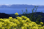
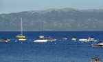
On Thur, 6/30, I passed by the dry Twin Lakes, ascended 800' on switchbacks up to Sand Harbor Overlook. On could see many sailboats on Lake Tahoe. On the high meadows many fine wildflowers were in bloom. I continued to Marlette Peak campground which had a water pump supplying cold clean water. The trail soon crossed Hobart Rd which leads down to Marlette lake. But I stayed in the high country with its fine views of lakes and peaks, enjoying a fresh breeze which keeps mosquitoes away and occasional snow patches fro cooling the drinking water. On the way I met the young TRT hiker from Gray Lake. He rested due to big and painful blisters caused by his mountain boots. He had used moleskin but to no avail. I suggested a slow hiking pace but in reality only time would heal the damage. Sadly we did not meet again.
By 3 pm I reached Spooner Summit at the intersection of the TRT with busy Hwy 50. The first challenge is to cross the high speed traffic on this road, which can require a long wait. Since cars are 30 times faster than hikers you need a distance of at least 30 times the road width from approaching cars to make it across alive. Next came the search for water which the guidebook stated would exist in the picnic area. Well, there was none to be found. This was bad news since a 14 mi dry stretch was coming up.
 Then I talked to some men who looked "official" whether they had seen any faucets. It turned out they were a TRTA trail crew who had just finished a day of hard work. They confirmed that there was no water at this trailhead but that they had left-over water to give me. They were true trail angels.
With 4 l of water I headed up from the Spooner trailhead to hike several more miles. After 17 mi hiking for the day I settled down on a ridge with fine views due east. Clouds have grown every day in Nevada but fizzled away in the evening.
Then I talked to some men who looked "official" whether they had seen any faucets. It turned out they were a TRTA trail crew who had just finished a day of hard work. They confirmed that there was no water at this trailhead but that they had left-over water to give me. They were true trail angels.
With 4 l of water I headed up from the Spooner trailhead to hike several more miles. After 17 mi hiking for the day I settled down on a ridge with fine views due east. Clouds have grown every day in Nevada but fizzled away in the evening.
On Fri, 7/1, the destination was Kingsbury Grade and beyond. From Spooner Summit the trail climbs 1,000' past Duane Bliss Pk, South Camp Pk and near Genoa Pk (9,150'). There were fine views alternating between the Lke Tahoe in the west and Washoo Valley in the east. By 1 pm I arrived at Kingsbury Grade and crossed Hwy 207 safely. There is one market in town, Tramway Market, where I wanted to buy some resupplies. It required a walk along Hwy 207 and another detour along Tramway Drive, but it was worth it. I had a fine lunch, shopped and refilled the water bottles. Then I returned to the trail and hiked past the Kingsbury South trailhead to find a nice campsite about a mile south of KBS. It was another 17 mi day.
On Sat, 7/2, I was up at 5 am when someone hiked up the trail. I would meet him later and we agreed that the morning hour is the best time to hike. This day would involve significant climbing near Freel Pk (10,881'). By 6 am I was heading up to Monument Pass (8,820'), continued to beautiful Star Lake (9,100') where I did a short dip into its cold water, passed below Freel Peak and switchbacked down to Armstrong Pass (8,700'). Needless to say there were many snow fields to cross. The clouds thickened in the afternoon and thunder rumbled, but no rain materialized. The trail was very busy with mountain bikers which jumped with their 4k$ bikes over rocks like gazelles. Although they were supposed to yield to hikers it was better for us mortals to move out of their way. But they were always polite to thank for it.
The trail from Kingsbury to Big Meadow is about 23 mi. Since July 4 was ahead I tried to finish the hike before Independence Day and kept going. I passed Freel Meadows, Grass Lake and got close to Big Meadow Trailhead on Hwy 89. Since I did not like car camping grounds I stayed at a creek before the trailhead and had a good rest for the upcoming day of 17.5 mi.
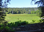
On Sun, 7/3, I was hiking by 6 am through Big Meadow. The grass was covered by frost, there was no sun in the valley and my fingers were bitingly cold. When the sun came out I warmed up, but so did the mosquitoes. Round Lake was pretty but occupied by lots of campers. Not much further was Meiss Meadow and Meiss Hut where the TRT joined again the PCT, which was familiar terrain from a few years earlier. Meiss picked in 1875 a lovely spot with green meadows, creeks and lakes surrounded by snow covered mountains. The trail passed by Showers Lake, equally busy with campers, then headed north and dropped with steep switchbacks down to Echo Summit.
 There was a last surprise, a PCT Trail Angel who offered cold drinks and cookies for thru hikers, even if the trail was only 165 mi long. I talked with those who came from Campo and felt at home with them. The Trail Angel was also living on the "trail" by supporting hikers from different trailheads during the summer, living year-round in a Camper Car and surviving winter in the SoCal desert.
From Echo Summit it was a short hike to Echo Lake where my car was parked. It was only 4 pm. I bought some refreshments at the store, then took another boat ride across Echo Lake since I wanted to hike back the 2.5 miles along the lakes which I skipped in the beginning. Now I can really say I hiked every mile of the TRT. It turned into a 20 mi day of hiking. By 5:30 pm I drove back home on Hwy 50, 80 and 101 to the Bay Area to celebrate the upcoming Independence Day with family and friends.
The trip was blessed with 10 days of perfect weather, beautiful sceneries, nice people and no injuries. I can only say: Go for it if you can.
Back to Trip Reports
Back to SMS Home Page