
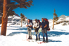
The crossing of the snow-covered Sierra Nevada is a true ski mountaineering adventure. It includes challenging backcountry skiing, climbing, orienteering, snowcamping, and self-reliance in the mountains for a week. For such an adventure it is good to have a small group of experienced friends.
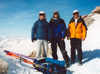
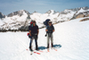
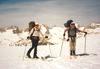
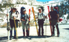 These were R.J. Secor, Duncan Livingston, Eric Watts, and myself. We skied from Onion Valley to Mineral King, crossing the Kings-Kern Divide and the Great Western Divide over 9 passes, covering some 42 mi and +17,000', -20,000' in elevation. As the detailed description shows, we had a wonderful experience blessed by best weather, excellent snow, good camaraderie, and no accidents/incidents. Here are the details:
On Fri, 4/28, I carpooled with Eric to Mineral King to meet Duncan who drove down from Southern Oregon. We carcamped at the road closure which is about 8 mi away from the trailhead. We spent the night in clouds from a cutoff low over Southern CA.
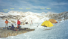
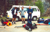
On Sat, 4/29, we left my VW bus at Mineral King and drove with Duncan's car to Onion Valley (9,200'). This took about 6 hours via Hwys 65, 178 (Walker Pass), 14, and 395. At 1:30 pm we met R.J. at Onion Valley where his father had given him a ride. Our 40+lb packs were stuffed with supplies for 8 days. We assorted our common gear (2 tents, 2 stoves, repair kit, maps), made last-minute route decisions, and started our tour at 3 pm. We decided to go over University Pass (12,640') into the upper Bubbs Creek rather than via Kearsarge Pass and the low Vidette Mdws.
 Although steeper, this avoided hiking below the snowline (9,000') and an uncertain stream crossing. It was one of many good route suggestions by R.J. who was in his familiar terrain. By 6 pm we were well above Robinson Lke (10,530') and set up camp on a high ridge (12,140') about 0.5 mi N of University Pass. We enjoyed the views down to Owens Valley and the sunset colors on the snow-covered Sierra peaks. When it got dark (8 pm) the birds and we went to bed.
Sun, 4/30. By sunrise (6 am) we got up, had breakfast, packed, and left by 8 am. It was another cloudless spring day. After a short scramble over rocks we used ice axe and crampons to ascend about 1,000' on hard snow to the summit of University Pass (10 am). From there we had a great view of the snow-covered backcountry: In the distance the rugged Kings-Kern Divide, nearby Center Peak which separates the Center Basin from the Bubbs Creek drainage. Of the various options to cross the Kings-Kern Divide, we chose to go for Forester Pass (13,200'), hoping that its steep South side would be passable.
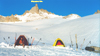
 Thus, we descended University Pass, the first 500' on rocks, then skied down to North of Golden Bear Lke around Center Peak and up Bubbs Crk toward Forester Pass. We passed some bright green lakes of glacial snow melt. By 5 pm, we found a pretty campsite on a ridge (12,530') about 0.5 mi N of Forester Pass. Another great view, but one had to be careful that the wind did not blow one's gear down the ridge onto Lke 12,237' below the pass. As the sunlight left the summit of nearby Junction Pk we retired to bed.
Mon, May Day, we continued our tradition to get up by sunrise, move by 8 am, and climb a pass while the snow was still frozen hard. Since the North side of Forester Pass is not too steep, three of us skied up with ski crampons.
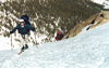
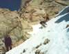 These fit under telemark bindings and give excellent lateral stability when traversing and turning on frozen slopes. We reached Forester Pass by 9 am and were greeted by a group of 3 skiers who just came up from the South side. This relieved our concern about crossing this high pass. But the descent was not trivial. With heavy packs, skis poking up, we front-pointed down a 45 deg chute of hard snow into which the ice axe would barely penetrate.
After this adrenaline rush we reached the safe terrain of the upper Tyndall Creek drainage. Around 10 am the snow corned up and it was easy cruising down the gentle open terrain between Diamond Mesa and the Caltech Pk ridge.
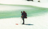
 Eric did a fine orienteering job and got us precisely down to the Kern River just above Milestone Crk (10,630'). The river was open but there were enough snowbridges for safe crossing. We enjoyed a long lunch break at the Kern and washed up in it's ice cold water on a warm spring day. Eric offered us fresh apples which were very delicious. The scent of pinetrees and the songs of birds were a pleasant change from the sterile high country of rocks and snow.
In the afternoon, we ascended along the High Route toward Milestone Mtn. The route goes up a most beautiful valley rimmed by steep mountains and terminated by the characteristic "finger" of Milestone Mtn (13,641').
 The creek flows partly below the snow, partly breaks through the snow, and sometimes gushes down an icy waterfall. Milestone Pass looks more intimidating than it actually is. To keep our tradition we camped below the pass to climb it in the morning. By 4:30 pm we spotted a small plateau for a perfect campsite. We cooked on a dry flat rock and overlooked the valley like marmots. High cirrus clouds moved in producing a ring around the sun, a typical sign that a front is moving in.
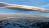 In the evening huge lenticular clouds formed over the Eastern Sierra Nevada. A different concern was R.J.'s plan to solo Midway Mtn next day. He would have a hard time to catch up with us, had no tent, stove, and it was 3 days to the nearest trailhead. Luckily, he overslept and we could proceed together.
On Tue, 5/2, 8 am, we ski-cramponed up to Milestone Pass (4,000m=13,123') reaching it by 10 am. The last few steps over the narrow ridge were quite exciting. Unfortunately, we had to take the skis off since the South side was still frozen hard and a fall down rock-studded Milestone Bowl was not advisable. After cramponing down to an acceptable angle we began to telemark in Milestone Bowl to where it drops 800' down into the headwaters of the Kern-Kaweah River.
 Somehow we had to cross this valley and get on a 12,000' high ridge on the other side of the big cirque South of Colby Pass. We tried to keep the elevation by circumnavigating, but it did not pay off. We spent too much time traversing steep slopes in soft snow and reached the base of the unnamed pass by 2 pm when it became unsafe to climb the steep mush. Various options were discussed and the vote was to wait till after 4 pm when the sun was off the slope, the snow had hardened, and it would be safer to climb it.
So it was time for loafing. We were dozing in the sun. Duncan got a book out and we read it aloud, taking turns each chapter. Once in a while Eric would dig a small pit to look at the snow stability. The hours passed by and finally, after the sun had left the slope, we started our ascent. The snow was less mushy now but the angle on this 12,000' pass became so steep that kickturns were at the limit of lifting one's leg. R.J. elected to climb up on foot, occasionally sinking in to the hips, performing an exhausting, heroic ascent. This lesson reminded us to stay with our usual schedule to climb passes in the morning, and it also showed that it is essentially impossible to traverse the Sierra without skis at this time of the year.
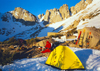
After we reached the unnamed 12,000' ridge, Triple Divide Pk (12,634') became visible to the West. We skied toward the upper lakes and stream which feed the Kern-Kaweah River and set up basecamp by 6:30 pm at 11,600', 1.5 mi NE of Triple Divide. The sun soon vanished behind a tall ridge in the West and we were in our bags by 8:30 pm. It became a cold clear night where waterbottles froze inside the tent.
On Wed, 5/3, we got up at 5:45 am to another cloudless day. After the usual morning business we began our ascent to Triple Divide Pass (12,210') by 8 am. Three of us skied with "harscheisen" and reached the pass by 9 am.
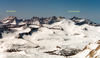
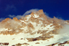
 While R.J. caught up, Eric and I made an attempt to climb Triple Divide. We ascended from the pass with ice axe and crampons along the NE ridge. However, precarious cornices covered the ridge near the summit, overhanging to the South and inclined by 45 deg to the North. Without ropes it became too dangerous to proceed. But we had a great view from the NE sub peak (12,400') which reached from the Palisades Range in the North to Olancha Pk in the South.
By 10 am we cramponed down T.D. Pass, then skied down to Glacier Lke where we encountered another group of skiers enjoying the corn snow in Cloud Cyn.
 We then contoured around the rock West of Glacier Lake and ascended Lion Lake Pass (11,610'). Below the rock the slopes were steep and hard frozen, requiring boot or ski crampons to avoid a long fall into Cloud Cyn. From Lion Lake Pass we skied down SE staying above Lion Lke (11,005') and headed up Lion Rock Pass (11,800'), 0.4 mi E of Lion Rock. Climbing a third pass this day became tiring, especially by midday in a bowl of intense sunlight without a breeze. In spite of ample sunscreen, chapstic and zinc, Eric got sunburned on the tongue.
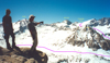
On Lion Rock Pass we met other skiers, superb athletes with light packs, zipping along the Great Western Divide.
 From the pass we had a wonderful ski run down into the Nine Lakes Basin. We stayed clear of the lakes which began to melt at the shore. We soon passed Kaweah Gap and could not stop our corn snow fun until we were in the Big Arroyo.
 By 4 pm we found a pretty campsite at 10,000' about 1 mi West of Eagle Scout Pk. It was next to open water of the Big Arroyo near trees and a dry flat rock for cooking. Since the sun was still strong we had another full-body wash, finding out that the scalp is the most sensitive part to ice water while a short barefoot walk through corn snow is very refreshing. After 5 pm clouds drifted in from the West. Fog rolled into the Big Arroyo but vanished later at night.
Thur, 5/4. Cold nights contrasted the blistering heat of midday. As we fetched water from the creek in the morning, a few minutes later it was coated with ice.
 We cooked, ate breakfast, packed, and left before the sun reached the valley floor. It was bumpy mogul skiing through the forest in the Big Arroyo.
Instead of following down to the Patrol Cabin we stayed high, contoured East of Lippincott Mtn, and headed toward the Little Five Lks. After a few hours of up and down skiing past forests, streams and lakes, we were above Lke 10,476' 1.5 mi E of Mt Eisen where one ascends toward Black Rock Pass.
We cooked, ate breakfast, packed, and left before the sun reached the valley floor. It was bumpy mogul skiing through the forest in the Big Arroyo.
Instead of following down to the Patrol Cabin we stayed high, contoured East of Lippincott Mtn, and headed toward the Little Five Lks. After a few hours of up and down skiing past forests, streams and lakes, we were above Lke 10,476' 1.5 mi E of Mt Eisen where one ascends toward Black Rock Pass.
We stopped for a lunch break and enjoyed the fabulous view of the nearby Kaweahs and the distant peaks of Whitney, Langley and Olancha.
 By early afternoon we skinned up to Black Rock Pass (11,600') which was luckily free of cornices. However, looking over to our next pass, Glacier Pass, we saw a row of menacing cornices and began to wonder how to get over/through them. After a farewell to the Kaweahs we skied down the Western side of Black Rock Pass on soft spring snow.
Three of us wanted to keep the elevation of Spring Lke (10,600') and contoured along mixed slushy snow fields and wet grassy slopes. I decided to ski a straight gully down to Cliff Crk and to skin back up to Spring Lke which turned out to be easier.

 We arrived by 4 pm, set up camp near a majestic pine tree at the upper Spring Lke, cut a hole into the lake for supply of fresh water, washed up, relaxed, and watched clouds forming over the Great Western Divide. At times, the clouds covered all peaks, at other times they all vanished. The San Joaquin Valley was entirely covered by clouds. While we ate dinner, another group of 4 skiers came down and camped near the lake. They had enviably light packs, but the price was an hour of setup time for their pyramid tent, after which they cooked and ate by darkness.
On Fri, 5/5, we had the first day without sun in the morning. It was humid and warm and clouds were rising from the West. The other group came over to discuss how to ascend the glaciated pass. We offered to try it first and they could follow us. Later we learned that they were all distinguished officials of the University of California.
By 8 am we ski-cramponed up the slopes West of Spring Lke, continued on a plateau to the base of Glacier Pass (11,200'), switched to boot crampons and kicked a line of steps into the soft snow. Energetic Duncan led the last section which lead between two cornices to the ridge. By 9 am we were relieved to have summitted our last pass. An hour later, 8 people stood on the Pass. We bid farewell to the other group and skied down direction Monarch Lke. It started out with superb corn snow skiing, but became softer and slushier further below. With one rocky exception we could ski down to the snowline at Groundhog Mdw where we picked up the trail and hiked down to Mineral King.
It was a pleasure to see flowers, butterflies, deer and a 500 lb bear. At 1 pm we lunched on the steps of the deserted Ranger Stn,
 then began the tedious 7 mi hike out to my car at the road closure. Duncan and I were trotting down the road, kicking pinecones, when suddenly a truck came out of a service road. Duncan's smile at the Rangerette saved us the last few miles of walking, much to the envy of our trailing party who joined us later at 4 pm. After condensing all the gear in my car we drove the winding MK road down to Three Rivers
![]() where we stopped at Reimer's Candy shop to load up on extra large vanilla shakes. Then we continued to Bakersfield, where we really filled up at the Sizzlers. The plan was to camp at Walker Pass, but since it was filled up we proceeded to Fossil Falls where, at 11 pm, I quit driving. We slept in the warm desert wind. Next morning, Eric discovered a new bedfellow, a 2 inch long scorpion.
where we stopped at Reimer's Candy shop to load up on extra large vanilla shakes. Then we continued to Bakersfield, where we really filled up at the Sizzlers. The plan was to camp at Walker Pass, but since it was filled up we proceeded to Fossil Falls where, at 11 pm, I quit driving. We slept in the warm desert wind. Next morning, Eric discovered a new bedfellow, a 2 inch long scorpion.
On Sat, 5/6, 7 am, we stopped for a grand slam breakfast at the Ranch House in Olancha, then drove up to Onion Valley to get Duncan's car. He had a long drive home to Klamath Falls compared to ours to LA. We all had the same feelings: It was a wonderful trip with a fine group of people. Thanks to everyone, especially to R.J. for his help to make it an official SPS/SMS trip.
Reiner Stenzel
Back to Trip Reports
Back to SMS Home Page