
On Saturday morning March 22, four skiers (participants Leslie Hofherr and Heiko Knapp, assistant leader Reiner Stenzel and provisional leader Mike McDermitt) met in the parking lot of the Ponderosa Lodge under clear skies. Just before 9am we began skiing from the snow-covered and snowmobile-groomed forest road just across the street (marked point 7157-T on the 7.5 minute Sentinel Peak topo). We skied westward along this road for about _ mile before making a left onto another snowmobile-groomed road (marked point 7208-T on the topo) and proceeding south about 0.1 mile, across a small stream and around a small bend. At this point we left the road and proceeded cross-country in a roughly southwesterly direction, along a modest ridge then upslope to a bench at 7840+ above the north fork of Peppermint Creek. There was some brush at first but well before reaching the bench the forest thinned out. After a break, we skied down in a southwest direction, dropping to about 7700', and crossed first a small tributary stream and then Peppermint Creek north fork. From here we skinned up the more northerly of the two arms of Slate Mountain which radiate eastward from below the summit, generally staying on the north side of the ridge. We made good progress and soon reached a bench at 8280+'. Here we took a break in warm sun and enjoyed vistas which were beginning to open up to the Mineral King area and to peaks in the eastern Sierra. With Heiko's prodding we got going again and made rapid progress to the bench at 8920+.
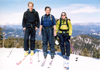
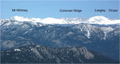
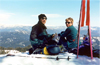 From here we proceeded southwest reaching a steep slope at approx. 9000' which marked the southeastern scarp of Slate Mountain's summit area. We carefully proceeded, one skier at a time, across this short steep slope, to the peak's south shoulder. From here we then made the short ascent of several hundred feet up the easy grade to the summit, which we reached at approximately 11.30am. Under sunny skies and a slight breeze we enjoyed lunch accompanied by near-360-degree views, from snow-streaked Mount Pinos area far to the southwest to the peaks of the Mineral King area in the north, northeast to the Whitney region and Langley, as well as east across the Little Kern and Kern rivers to such peaks as Coyote, Angora and Siretta. Not to mention, the San Joaquin Valley spread out 9000' directly below us to the west!
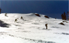
 After about an hour on the summit, we moved on. Reiner and Heiko tried skiing down slopes from a few feet north of the summit but found the snow a bit too unconsolidated and heavy to be much fun. So we skied NNE along the ridge, then dropped down the open slopes on the east side of the summit from about the 9000' level. While not perfect, the snow was nevertheless more than sufficiently consolidated to make good turns and we enjoyed several hundred feet of descent.
We then continued down through open trees with very enjoyable skiing, going several hundred at a time then regrouping, with the snow quality improving somewhat at lower elevations, along the same ridge we had ascended. Somewhere at about the 7700' level Heiko spotted a snow-covered forest road (not on the topo), and we decided to follow it. It wound south, eventually reaching a stream (which is on the topo). We crossed the stream then skied down along it back to Peppermint Creek north fork at approx. 7360'.
After about an hour on the summit, we moved on. Reiner and Heiko tried skiing down slopes from a few feet north of the summit but found the snow a bit too unconsolidated and heavy to be much fun. So we skied NNE along the ridge, then dropped down the open slopes on the east side of the summit from about the 9000' level. While not perfect, the snow was nevertheless more than sufficiently consolidated to make good turns and we enjoyed several hundred feet of descent.
We then continued down through open trees with very enjoyable skiing, going several hundred at a time then regrouping, with the snow quality improving somewhat at lower elevations, along the same ridge we had ascended. Somewhere at about the 7700' level Heiko spotted a snow-covered forest road (not on the topo), and we decided to follow it. It wound south, eventually reaching a stream (which is on the topo). We crossed the stream then skied down along it back to Peppermint Creek north fork at approx. 7360'.
 At this point the downhill was over and at this low elevation the brush and occasional melted areas without snow became somewhat of a factor. We proceed northeasterly over a low rise then onward and before too long reached the snowmobile groomed road from which we had originally started going cross-country, at a point maybe _ mile south of the point 7208-T intersection. From here we rapidly made our way back to the Ponderosa parking lot, getting our boots off around 3:30pm. The day's totals were about 6 miles and 2400' gross/ 2100' net gain.
Saturday afternoon was occupied by Heiko's car troubles = the car wouldn't start. Even with the assistance of several knowledgeable local people it would not start. Ultimately a short tow to the hill crest north of Ponderosa and then a glide down the hill to Camp Nelson got it going, at which point Heiko made the appropriate decision to continue back to LA. Saturday evening the three remaining skiers enjoyed the warmth of a charcoal grill with dinner.
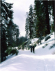 Sunday morning at 7am we drove north to North Road, a paved road which leaves Highway 190 at the ~7000' level and runs north. It was plowed for about 100 feet; we parked at road end and after gearing up, our group of three was skiing by about 7.45am. The trip plan this day was fairly simple, skiing along snowcovered North Road (21S50), then cross-country to Jordan Peak. North Road turned out to have a lot of very moderate up and down, making for somewhat inefficient progress. After an initial gain of several hundred feet in the first mile, the next five or six miles netted only another few hundred feet. Unlike the prior day, Sunday was windy and cloudy as a front moved through, and we were glad to be in well-protected terrain. Views were quite limited by the weather. One interesting surprise was finding a very nice yurt-type shelter in the vicinity of Log Cabin Meadow. By about 1pm we reached the 8000' level about a mile north of Log Cabin Meadow and started cross-country on a line towards the saddle just NNE of Jordan Peak. Open rolling terrain soon gave way to steeper, brushier terrain with unconsolidated snow. Happily our course intersected with a snowcovered road (31E35) and we continued more easily up the road to a marked bend at 8600'.
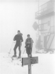
 We then made a short climb to the saddle, then continued up the northeast shoulder of Jordan Peak. The weather was poor and as we climbed, although protected by the open forest, visibility was limited. On reaching the summit at about 2pm visibility was down to less than 50 feet and winds were gusting to perhaps 25-30 mph or more. After a short food break just below the summit, we headed down. This route offered only a short distance for making turns. Soon reaching road 31E35, we enjoyed a steady downhill glide back to the intersection with North Road at 8240+. From here, in occasional sleet and snow showers, we retraced the lengthy up-and-down approach, back to the cars, which we reached at around 6pm. The day's totals were about 16 miles and 2600' gross/ 2100' net gain.
TRIP PLANNING NOTES: These peaks are located in Sequoia National Forest. Aside from the 7.5' topos, this area is well covered by the USFS Golden Trout Wilderness Map. Highway 190 beyond Springville is nicely paved but very windy, and the 27-mile drive from Springville to Ponderosa takes a good hour. Hwy 190 officially ends at North Road, becoming Western Divide Highway. Ponderosa Lodge is open year-round and offers food and lodging plus a general store. More info on the entire area is available at www.ponderosaca.com. Parking at the snow park (or possibly area surface streets) rather than the lodge is recommended unless you are a lodge guest. I found the lodge to offer an excellent dinner, with friendly efficient service, at a very good price. Jordan Peak is said to get more snow than Slate Mountain (and our experience supports that) however, for downhill skiers it is unclear if Jordan's slopes can be accessed without a long approach (but the yurt, stove and all, might tempt an overnight). An alternative may be from the Hossack Meadow/ Alder Creek Grove area via Rte. 216. In any event, Slate has the convenience of a nearby snowpark and seems to offer both more vertical and more variety of slopes.
Back to Trip Reports
Back to SMS Home Page