
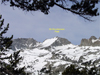
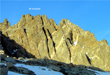
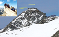
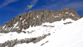
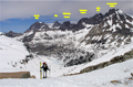
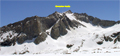
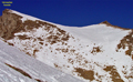
 The Sierra Crest route has got to be one of the most scenic stretches of mountain scenery in the world. The section between Bishop and Taboose passes is the crown jewel of mountain scenery along that route. From the west encampment of the Palisades, the Black Divide stands out in great contrast to the series of ranges to the west cumulating in the eerie contortions of the Devils Crags against the shear vertical ridge of the Palisade Range.
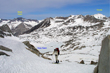
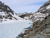
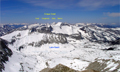
 This is contrasted with the amphitheater feel of the Palisades Lakes Basin with its towering cathedral walls in all directions. Not to forget the vast immensity of the Upper Basin with its gently rolling terrain in the backdrop of the giant mountains to the west, north and east. It's hard to imagine a finer place for a spring ski tour. As the date got closer to the trip, many of the eight original participants dropped out. The weather forecast was ideal with sunny to partly cloudy skies and temperatures in the 60s. All the right factors were in place for a truely epic ski tour.
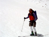
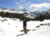
 Reiner Stenzel, Mike Rector and I met at the Taboose Creek Campground on Saturday, 5/15/04, at 6am for the short car shuttle to our end point at the Taboose Creek trailhead. We left Reiner's Subaru and proceeded with my truck to Bishop by 8am with a fuel break at Shats's bakery. We finally made our ascent towards Bishop Pass from South Lake at 10am. It was easy going on the trail for the first couple of miles as we encountered little snow. We had a fine view of the SMS Peak on the Thompson Ridge. What snow we did encounter was firm. We made excellent time on the intermittent snow sections. By the time we arrived at the western edge of Long Lake we had fairly continuous snow, so we donned skis.
 When we arrived at the Bishop Lakes, we found our fourth participant in the group, Don Ralphs. Don had arrived the night before for some acclimation. That being a good thing, since we would be above 11,000 feet in elevation for several days. Feeling good at that point, we decided to go over Bishop Pass. Reiner cut an excellent ski route up to the top (11,950').
 We then traversed as best as we could on the intermittent snow and rock to our campsite between the western slopes of Agassiz and Winchell at an elevation of 11,775', well above Lake 11,393. It was with great pleasure to see the light show that occurred at sunset on our perch high above the western basin. Changing colors of pink and red graced the mountains to the east. It didn't take too long after the setting of the sun that the relative warmth of the sleeping bags was a great relief from the cold.
Sunday
 was truly an epic day. It started out with a 9am start from our campsite on hard pack from the late sun hitting this western edge of the Palisade. Given the steepness of the traverse and the firmness of the snow pack, we decided to add ski crampons to our skis for the ascent to Thunderbolt Col.
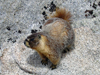
 Reiner, Mike and I all had trouble with our Rainey ski bindings. One of Reiner's crampons broke on one side rendering it useless. Mike and I struggled with the bindings flipping off on the hard pack. It's somewhat unnerving to have to take your skis off on a steep icy slope to adjust your binding. Mike was able to fashion the ski retention straps around the binding to keep it in place on both our skis. Reiner was able to get by with one crampon on the downhill side. It all seemed to work out. Lesson learned in the use of crampons. We made good time getting summitting Thunderbolt Pass (12,360') by 10:30am. Certainly easier than attempting this Col in the summer time with its car-sized boulders. A bold marmot made it down to Mike's pack for a hoped for snack as we soaked up the first glimpses of the magnificent views to the west. The snow was still hard as we scooted down the south side of the pass onto the wide bench at the base of the Palisade well above the Barrett Lakes.
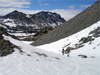
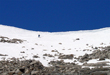
 As described earlier, this is an incredibly scenic place. We hugged the sheer vertical mountains to the east on our high traverse below North Palisade and polemonium to Potluck Pass. Partly cloudy skies made a surreal contrast to the topography below. We made good time in arriving at Potluck Pass (12,120'). The north side was skiable, the south side had mixed rock and snow. Upon inspection, it made sense to get creative with a scramble through the rock band to the base of Glacier Creek. The sun was warm and the wind calm as we luxuriated in the sun near Lake 11,672, the source of Glacier Creek. After lunch, Don had the honorable task of tracking a route up to the top of Cirque Pass (12,100'). The gradual ascent was well appreciated, as I was a bit tired at that point. The following descent down to the Palisade Lakes was another truly epic experience.
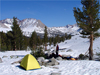
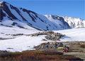
 The snow was wonderfully soft on a firm base as we skied about 1,500 feet down the canyon before running out of snow. Then the skis came off and a cumbersome rock scramble started. The trouble with trouble is that it always starts with fun :). Luckily Reiner was able to find a route down towards the outlet of Lower Palisades Lakes thereby avoiding a difficult cliff band. The last � mile to camp was on snow as we picked our way around the rocks. We found a wonderful campsite at the outlet of the Lower Palisade Lake (10,527'), complete with waterfalls, flat rocks, and impressive scenery.
Monday
 would prove to be a respite from our prior two days, as we had to only get over only one pass (as opposed to three passes the day before). However, it was the highest and possibly most difficult pass of the trip, Mather Pass (12,100').
To quote from Steve Roper's second edition of the "Sierra High Route", "Mather Pass was first visited in 1897, when a sheep man apparently negotiated the rough crossing with his burro. By the early 1920s it was certain that the Muir Trail would be rerouted over the lofty saddle, named in 1921 in honor of Stephen Mather, the first director of the National Park Service. For various reasons, it was not until 1938 that the last link of the famed trail was built, capping an effort that had begun nearly a quarter century earlier."
would prove to be a respite from our prior two days, as we had to only get over only one pass (as opposed to three passes the day before). However, it was the highest and possibly most difficult pass of the trip, Mather Pass (12,100').
To quote from Steve Roper's second edition of the "Sierra High Route", "Mather Pass was first visited in 1897, when a sheep man apparently negotiated the rough crossing with his burro. By the early 1920s it was certain that the Muir Trail would be rerouted over the lofty saddle, named in 1921 in honor of Stephen Mather, the first director of the National Park Service. For various reasons, it was not until 1938 that the last link of the famed trail was built, capping an effort that had begun nearly a quarter century earlier."
 The day dawned as gloriously sunny, warm and calm as the day before. We had to pack our skis for the traverse around lower Palisades Lake as Reiner had found holes in the ice making it too treacherous to cross the lake. The John Muir Trail sweeps up about 300 feet from the lake, providing a good highway through the rocks. Some of us made a short detour before finding the trail. Upon reaching the south side of the upper Palisade Lake, Reiner was able to find a solid snow bridge in which to cross the gushing creek between the two Palisade Lakes. We were then on continuous snow for the rest of the day.
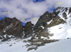
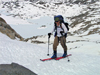
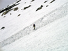
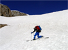
 It was fine ski touring to the base of Mather Pass as we stopped for water and a snack near an open creek. The climb up Mather Pass was not without effort. Reiner led the way with multiple traverses on a soft one inch on firm base. It was with great relief that the pass was reached. You can see it in Movie 1 of Don hiking up and another Movie 2 where he enjoyed skiing down. We had concern about a possible rock scramble on the south side of Mather Pass similar to Potluck Pass the day before. However, the map showed that Mather Pass had a much longer decent through steep terrain. So it was with great joy that the south side of Mather was still covered with soft snow. However, there was a 5' cornice along the entire Pass. The swich-backs of the summer trail were not visible. The ski route down through the snow was over a steep southern exposure and then a traverse around a narrow band of snow and a turn to the east side.
Don on his randonnee gear was comfortable enough to ski down from the top of the pass. The rest of us booted down for a while so as to avoid a possible fall into rocks. Then we telemarked down the rest of the pass.
It was fine ski touring to the base of Mather Pass as we stopped for water and a snack near an open creek. The climb up Mather Pass was not without effort. Reiner led the way with multiple traverses on a soft one inch on firm base. It was with great relief that the pass was reached. You can see it in Movie 1 of Don hiking up and another Movie 2 where he enjoyed skiing down. We had concern about a possible rock scramble on the south side of Mather Pass similar to Potluck Pass the day before. However, the map showed that Mather Pass had a much longer decent through steep terrain. So it was with great joy that the south side of Mather was still covered with soft snow. However, there was a 5' cornice along the entire Pass. The swich-backs of the summer trail were not visible. The ski route down through the snow was over a steep southern exposure and then a traverse around a narrow band of snow and a turn to the east side.
Don on his randonnee gear was comfortable enough to ski down from the top of the pass. The rest of us booted down for a while so as to avoid a possible fall into rocks. Then we telemarked down the rest of the pass.
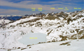
 The ski down the southeast facing slope was classic. It had a smooth surface of a couple inches of spring snow on a firm base. Just perfect for what seemed like endless telemark turns down to the flat Upper Basin. By that time, it was only around 2pm and the 7-8 mile death march that Reiner had mentioned never materialized. We made quick work gliding down the gradual slopes of the Upper Basin to our camp below the Vennacher Needle. We had the whole immense Upper Basin to ourselves as we peered at one ski slope after another. Reiner pointed out the route up Frozen Lake Pass that he had done two years earlier on the
Cirque Crest Traverse. The sky was partly cloudy reflecting contracting images of shade on the immense white landscape. Unfortunately, there was not enough snow coverage on Split Mtn which was one of our possible ski ascents.
The ski down the southeast facing slope was classic. It had a smooth surface of a couple inches of spring snow on a firm base. Just perfect for what seemed like endless telemark turns down to the flat Upper Basin. By that time, it was only around 2pm and the 7-8 mile death march that Reiner had mentioned never materialized. We made quick work gliding down the gradual slopes of the Upper Basin to our camp below the Vennacher Needle. We had the whole immense Upper Basin to ourselves as we peered at one ski slope after another. Reiner pointed out the route up Frozen Lake Pass that he had done two years earlier on the
Cirque Crest Traverse. The sky was partly cloudy reflecting contracting images of shade on the immense white landscape. Unfortunately, there was not enough snow coverage on Split Mtn which was one of our possible ski ascents.
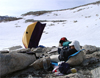
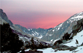
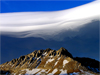
 That evening, we were treated with one of the best light shows ever experienced in the Sierra Nevada. A lenticular cloud had formed over the Sierra Crest from beyond Taboose in the south to the Palisade Range in the north. It was unusually continuous but it changed shapes around the edges with the changing evening light. The next day,Tuesday, Reiner and Mike decided to make the ski ascent of Vennacher Needle, while Don and I stay back in camp to enjoy the luxury of the warm sun, calm winds and fine scenery. Don had lost his hat while skiing down Mather Pass the day before, so he fashioned a shirt around his head to block the sun exposure. After that he was known as the Sheik and responded well to being referred to as "Your Excellency".
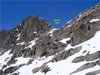
 Climbing and skiing the Vennacher Needle was not as easy as it looked.
After passing the initially gentle southeast slopes along a series of small lakes one has to ascend some steep slopes before reaching the plateau between two summits. In spite of the sunshine the cold wind kept the snow hard packed. Edging was critical and kickturns without ski crampons kept the adrenaline flowing. The summit plateau had another surprise: Frozen suncups, appropriately called Vennacher "needles". We summitted around 11am on this 12,996' peak. No peak register was found since the peak is not on a "List". Its name is neither explained in standard books.
Climbing and skiing the Vennacher Needle was not as easy as it looked.
After passing the initially gentle southeast slopes along a series of small lakes one has to ascend some steep slopes before reaching the plateau between two summits. In spite of the sunshine the cold wind kept the snow hard packed. Edging was critical and kickturns without ski crampons kept the adrenaline flowing. The summit plateau had another surprise: Frozen suncups, appropriately called Vennacher "needles". We summitted around 11am on this 12,996' peak. No peak register was found since the peak is not on a "List". Its name is neither explained in standard books.
 After turning many rocks around a plastic bag with a sheet and signatures from last July was located. I (Reiner) built a proper cairn, put the sheets into a plastic box and left signs of our presence in it. Mike and I enjoyed the spectacular views from this fine summit. But by noon the snow was still hard. Mike decided to boot down the frozen suncups while I tried to ski them. No problem when crossing the grooves but it was a balancing act when skiing along them. A few tele turns were possible but much of the Needle was a pain, until we reached the lower slopes.
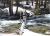
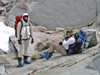
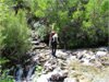
 Reiner and Mike made it down to camp by 1:30pm. After that, we packed up and made our way down on intermittent snow to a crossing of the South Fork of the King's River. After much searching Reiner had spotted a log across the river that we all took turns crossing with ski poles in one hand, skis in the other and a heavy pack on the back. It was not without great excitement that we crossed the creek. One slip on the log with our wet ski boots into the gushing river would have been quite serious. Luckily, we all made it across safely, with a couple seconds of high concern as Don wavered back and forth in the middle of the creek.
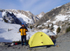
 Reiner then picked a straight, steep route out of the creek area through the forest up into the Taboose Creek drainage. By the time the terrain had leveled out, we were on continuous snow once again. The trek to Taboose Pass was very gradual. As it got past 5pm at the Pass we decided to camp on a snow-free meadow just below the Pass where there was less wind and running water. It proved to be not as cold as we thought with a gentle breeze grazing our camp as the sun dipped below the horizon. However, it was our coldest camp on the trip, so it did not take a lot of convincing to persuade anyone to retire early to the tents. Don's tent was experimental as he hunkered down under the thin airy single-wall Mountain Gear version of a one-man, three-season tent. In the morning, water bottles and streams were all frozen.
 Wednesday morning, we luxuriated in the early sun at our camp until 9:30am. This allowed the snow to soften up a bit for our descent. It was perfect timing as we hit the southeast-facing slopes right as the top layer had ripened up. It was wonderful skiing for about 1200 feet down before we resigned to following the trail down. Don got another 300-400 feet with a couple short rock scrambles and bushwhacking. We made excellent time on our descent to Reiner's car at the Taboose Creek trailhead. The day was cool and the relative arid nature of the lower trail was quite pleasant. We packed all four of us with gear into Reiner's Subaru and he drove up to South Lake to complete the car shuttle and tour by 3pm.
 Some trips just meet expectations in terms of weather, scenery, friendship and conditions. This trip certainly surpassed it in my mind. With 6 passes and one peak climbed it was certainly a challenging trip. Special thanks to Reiner for leading the way and to Mike for being such a good sport about carrying the tent, doing most of the cooking, fixing my ski crampons, and to Don for being always positive and entertaining.
Back to Trip Reports
Back to SMS Home Page