|
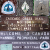
This is a continuation of the trip report "Pacific Crest Trail-Part 1: Southern California" and "Pacific Crest Trail-Part 2: The Sierra Nevada" and "Pacific Crest Trail-Part 3: Northern California" and "Pacific Crest Trail-Part 4: Oregon". It will describe the trip through Washington, i.e. from Cascade Locks to Manning Park, Canada.
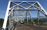
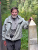
 I crossed the Bridge of the Gods with mixed feelings. On the one hand I had gained confidence from having come here on foot from the Mexican border; on the other hand I wondered what Washington would bring. I was ready for new adventures, memories of old ski trips on some Oregon volcanoes and Washington volcanoes 10 years earlier, but now as a "senior" I also had some concern about the upcoming tough terrain and uncertain weather. However, my timing for the trip was optimal, July-August is the best hiking season and I was not under time pressure. I did not have the pressure of thru hikers who have to make a 20+ mi every day or get rained/snowed out in the Cascades. Section hiking is the way to go if one wants to enjoy the PCT and most people I met here were doing that. After all, it is a "Scenic" trail and not a racing track.
 The transition from one state to the next is gradual. Starting at the Columbia Gorge from nearly sea level the PCT climbs gently into the high country. I took it easy on the first day since I had a full resupply for the long stretch of 150 miles to White Pass. On Thur, 7/17, morning I had a filling breakfast at the Charburger. I met George for the last time since he had completed his planned section hike through his home state of Oregon and was heading for a job in Idaho. At 10 am I crossed the state line and climbed the trail to Gillette Lake (mi 2159). Old habits don't die and during lunch break I took a short swim in the lake. In the afternoon I hiked up to the waterhole at mi 2163 to add 3 l for an upcoming dry stretch of 11 miles. By 6:30 pm I found a small campsite at mi 2167 and settled down for a Ramen dinner since I was still full from the previous sumptuous meals. Fresh blueberries from nearby bushes were a delicious desert. Although I covered only a short distance I was confident that I could manage climbing with a heavy pack without problems other than lots of perspiration.
 Up at 5:45 am on Fri, 7/18, I started the hike to 3,000' ridge near the Three Rock Corner, then up to a 3,000' ridge, then down to 1,500' at Rock Creek, around Bunker Hill down to 940' at the big Wind River where I set up camp at 6:30 pm for this 22 mi day. It was a nice day where I met 3 sobos, a trail angel Toad, and nobos Redbeard and John.

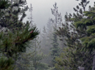
 On Sat, 7/19, I hiked up to Panther Creek. The flat land was over and a 3,000' ascent started. Furthermore there was a 13 mi dry stretch which required a 2 l water load on top of the heavy pack. After this work out the pipe-fed spring water at mi 2204 was so delicious. The hike continued past lava flows and buttes to a nice camp site at Crest Horse Camp (mi 2207) where I settled down after 19 mi day around 5:30 pm. In the evening it became cloudy and I head a hunch that WA started like OR.
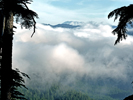
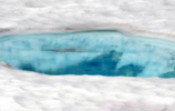
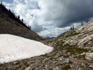
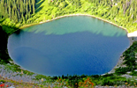
 On Sun, 7/20, I was on the trail by 6:30am. An hour later the rain started. Lots of nice lakes but in the white-out the lakes all appeared grey instead of green-blue. Snow patches on the trail started beyond Deer Lke above 5,200'. Passed between the East and West Twin Buttes to appropriately named Mosquito Lake (mi 2227) where weather improved but the shoes and socks remained flooded by plant water. I elected an early stop at the pretty Steamboat Lake to dry my wet gear. Later others joined. Had an early dinner and was sleeping by 7 pm like the birds.
 On Mon, 7/21, I was hiking by 6:15 am approximately, since the battery of my wrist watch had died. No watch gives one a new feeling of freedom; you rise when it gets light, go to sleep when it darkens, walk for the rest of the day without time pressure. I was supposed to get close to Mt Adams but the trees and fog did not allow me to see this big volcano. I picked up water at Trout Lake
Creek and crossed the paved Forest Road 23, from where a 14 mi hitch leads to Trout Lake. Since I am not fond of hitch hiking I avoided resupplying in Trout Lake but paid the price by carrying food for 8 days.
On Mon, 7/21, I was hiking by 6:15 am approximately, since the battery of my wrist watch had died. No watch gives one a new feeling of freedom; you rise when it gets light, go to sleep when it darkens, walk for the rest of the day without time pressure. I was supposed to get close to Mt Adams but the trees and fog did not allow me to see this big volcano. I picked up water at Trout Lake
Creek and crossed the paved Forest Road 23, from where a 14 mi hitch leads to Trout Lake. Since I am not fond of hitch hiking I avoided resupplying in Trout Lake but paid the price by carrying food for 8 days.
 The trail continued to rise toward Mt Adams. People were camped in the open Horseshoe Meadow. I explored Sheep Lake for a campsite but this nice place was trashed with discarded camping gear. Who could be so thoughtless? So I continued along the western slopes of Adams to a campsite 2249 in a Lava bed with a nearby stream. The tent poles did not stick well in the black lava sand but rocks solved the problem. Some fast hikers passed by. By 8 pm my 19 mi day put me asleep. By midnight I heard raindrops on the tent.
Then it rained continuous and strong all night long.
The trail continued to rise toward Mt Adams. People were camped in the open Horseshoe Meadow. I explored Sheep Lake for a campsite but this nice place was trashed with discarded camping gear. Who could be so thoughtless? So I continued along the western slopes of Adams to a campsite 2249 in a Lava bed with a nearby stream. The tent poles did not stick well in the black lava sand but rocks solved the problem. Some fast hikers passed by. By 8 pm my 19 mi day put me asleep. By midnight I heard raindrops on the tent.
Then it rained continuous and strong all night long.
 Tue, 7/22: It still rained and rained hard. I considered to make a layover day. In the rain a solo hiker passed by and greeted. Half an hour later the same hiker passed by again but in the opposite direction. I asked what happened and she said she had no GPS and got lost in the snow and lava beds. So I suggested to settle down to get out of the rain and she could later follow me since I had a GPS to find the trail. We camped and waited for the end of the rain. By noon there was a break in the rain and we started. Both of us headed for
Canada, so we hiked more or less together. Indeed the terrain became tricky and I also got initially in trouble with finding the right way.
Tue, 7/22: It still rained and rained hard. I considered to make a layover day. In the rain a solo hiker passed by and greeted. Half an hour later the same hiker passed by again but in the opposite direction. I asked what happened and she said she had no GPS and got lost in the snow and lava beds. So I suggested to settle down to get out of the rain and she could later follow me since I had a GPS to find the trail. We camped and waited for the end of the rain. By noon there was a break in the rain and we started. Both of us headed for
Canada, so we hiked more or less together. Indeed the terrain became tricky and I also got initially in trouble with finding the right way.
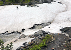
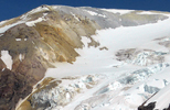
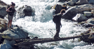
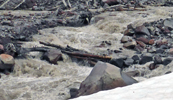 Several stream crossings followed, the most difficult of which was the rain-swollen glacial Adams Creek with three branches. We waded through two of them and balanced over the strongest middle one on wet thin tree logs. We made it safely, although the bottom half was wet and cold and sandy. The hike continued to above 6,000' elevation where we crossed many snow patches. We passed by more lava beds (mi 2258) and then descended toward Potato Hill (mi 2260). Denise met a friend at a Forest Road crossing. Soon thereafter thunder and lightning started. It rained on and off. There were no suitable camping places anywhere. Furthermore, to the right hand side of the trail was the Yakima Indian Reservation with stern warning of "No Trespassing". Eventually, we found some small spots in the forest to set up one-person tents in intermittent rain. Did only 12 miles, but we hiked only half a day in rain and snow and had some tough stream crossings. When the rain dropped on the tent I thought tomorrow it could only get better.
 On Wed, 7/23, it did not get better. The uniformly grey sky produced rain, thunder and lightning already in the morning. Without change there was no point of waiting. We got into our wet clothes and marched in the rain by 8 am. The trail was a line of puddles which one first avoided by stepping to the sides, later ignored it since stepping into the puddles gave a nice foot wash and was actually safer than sliding off the slanted slippery trail edges. It was a pity that we could not enjoy the many nice lakes near the trail. But hiking in cold rain does not allow for stopping which rapidly cools off the wet body. One has to keep walking and eat a powerbar every hour to generate the heat lost. That's what we did up to the last water hole at mi 2277 before the trail begins a steep ascent into the Goat Rocks. Around 5 pm we set up the wet tents, changed into the last set of dry clothes, prepared a freeze-dried dinner and ate it while in the dry sleeping bag. It felt good to be warm and dry while outside it was raining, foggy and windy. A hiker passed by and greeted us. It was a single young woman on a sobo thru hike who had just crossed to Goat Ridge in this storm. Tough, yes, sane, no.
 Thur, 7/24. was day 3 of continued wind, rain and whiteout. Obviously, it would be foolish to cross the most scenic trail section in a storm. But we were 26 mi from the next resupply place, White Pass, and food supplies dwindled. But I was prepared for such cases and had extra food to share. So we decided to give it one more chance to wait out the storm. But a zero day confined to a small tent in the rain is not exactly fun. Furthermore, I had developed pain from a fall on clay soil the day before. But a rest day was a better choice than pushing through a storm over an exposed ridge.
 P P
 Fri, 7/25. brought what I was hoping for: The rain front had passed, there was not a cloud in the sky and warm sunshine was back! We got up at 6 am, packed up our wet gear and started climbing at 7 am. We crossed Cispus Pass (mi 2280), refilled water bottles from Cispus Creek, climbed up to Showgrass where we had lunch and dried our wet gear on rocks in full sunshine. Somewhere on this trail, Denise sprained her ankle which caused great pain and swelling.
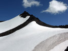
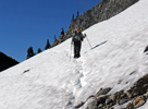
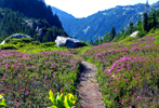
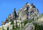
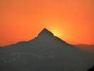
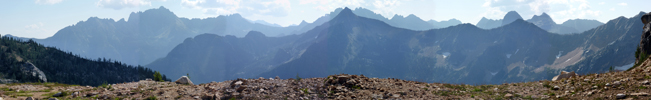
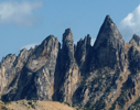
 Then came the ascent toward Old Snowy Mtn, the highest peak of the Goat Rocks. We chose the upper Hikers Trail because it offered wonderful views compared to the lower Horse Trail which side hilled on steep snow fields. There were many photo opportunities on this clear and sunny day. The peak name was appropriate since there was still so much snow on "Old Snowy". The switchbacks on lava soil needed some attention but were not dangerous. The trail continues north along the ridge but bypasses most summits on the way. Beyond Elk Pass it turns east and passes by Lutz Lake (mi 2290) where we stopped at 6:30 pm. The next day it would be an easy 13 mi down to White Pass, our next resupply place.
 On Sat, 7/26, we hiked down to Tieton Pass, had a fine view of blue Shoe Lake on the way up to the ski lifts, then took a shortcut down the Chairlift Trail and through town to the White Pass Village Inn and Kracker Barrel Store. I rented a nice room for 2 nights for a true zero day, took a shower, did the laundry, picked up my resupply parcels, ate a nice sandwich for late lunch and pizza for an early dinner, and mingled with other PCT hikers. By 8 pm I enjoyed to sleep in a real bed instead of a moist tent.
 Sun, 7/27, was an easy-going day. After a good breakfast I shopped a bit for needed supplies (HEET), then went on a hike around the Leech Lake, ate another sandwich for lunch, another pizza for dinner, had more beer for both, called and e-mailed and packed for the next day.
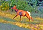
On Mon, 7/28, we got back on the trail supplied with 100 mi worth of food to Snoqualmie Pass. This section would pass east of Mt Rainier, the highest Cascade volcano. In the early morning we saw a female elk with a baby near the Leech Lake. The trail passed by many fine lakes such as Deer Lke, Sand Lke, Buesh Lke and Snow Lke where I had a dip with dozens of mosquito bites. I refilled clean water at mi 2317-18, had a wet fording across Bumping River and by 6 pm decided to stay at Crag Lake (mi 2320) where others joined later too (Happyfoot with friend).
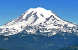
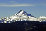
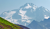
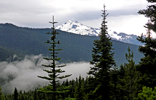
 On Tue, 7/29, we had a late start to ascend about 1000' to pretty Anderson and Dewey Lke to reach Chinook Pass (Hwy 410), then continued to Sheep Lke where we camped at 5:30 pm. It was a fine summer day with great views of Mt Rainier. We met and talked to several nobos and sobos. The 14 mi day was easy but why rush? August is the best time for hiking Washington and we were almost one third through.
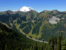
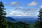
 On Wed, 7/30, we left Sheep Lake at 6 am to ascend several passes with fine views of Mt Rainier and the Goat Rocks. Since the morning was clear one could even make out snow covered peaks far to the west, presumably the
Olympic Range. Near mi 2340 there was a fine view of the Crystal Mtn ski resort with Mt Rainier in the background. A few hours later we passed by Arch Rock (mi 2350) but since it was fairly early we decided to continue to Government Meadow and camped near the Urich Shelter (mi 2356) which made this a 22 mi day. We did not stay inside the hut since it is also occupied by small four-legged inhabitants.
On Wed, 7/30, we left Sheep Lake at 6 am to ascend several passes with fine views of Mt Rainier and the Goat Rocks. Since the morning was clear one could even make out snow covered peaks far to the west, presumably the
Olympic Range. Near mi 2340 there was a fine view of the Crystal Mtn ski resort with Mt Rainier in the background. A few hours later we passed by Arch Rock (mi 2350) but since it was fairly early we decided to continue to Government Meadow and camped near the Urich Shelter (mi 2356) which made this a 22 mi day. We did not stay inside the hut since it is also occupied by small four-legged inhabitants.
 On Thur, 7/30, we were up and hiking by 6 am. At mi 2360 I filled up water for a 12 mi dry stretch. It went over many small passes or gaps and dirt road intersections. We had lunch at Blowout Mtn (mi 2366). By 5:30 pm we filled up 3 l of delicious spring water at mi 2372 and brought it to the nice campsite at Tacoma Pass (mi 2373). Other PCT hikers also camped there.
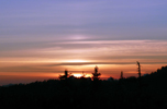
 On Fri, 8/1, the day started again with a bloody red sunrise which often indicates rain in the evening. We hiked from one water source to the next and crossed several broad swaths of cut trees to make space for transmission lines to Seattle. Washington runs mostly on hydroelectric power. Near Lizzard Lake someone in the forest was practicing with a shot gun and we were walking a bit faster to get out of the unknown target zone. At 1 pm it started to thunder and rain, but only intermittently. We met two old ladies on horses and chatted for a while. They had done the PCT in OR and WA many times on horses which is quite a feat. Our hiking progress often slowed down since there were many ripe blueberries and salmonberries. The map indicated a campsite at Twilight Lake near Yakima Pass (mi 2392), but when we arrived the campsite was on a little island in a marsh. After a wet approach it turned out to be quite scenic. Besides, next day we would be in a comfortable rooms at Snoqualmie Pass, only 10 mi to go.
 On Sat, 8/2, we hiked by 6:30 am to Mirror Lake, Twin Lake and Lodge Lake down to Snoqualmie Pass Summit Lodge (mi 2402) where we had made room reservations from the trail. We arrived just in time before the afternoon thunderstorm started. We checked in, then headed to the Aardvark food place and PCT hangout to meet new and old friends. I called my brother in law Juichi who lives in Seattle and he decided on the spur of the moment to visit me next day. Denise also had visit from her mother. Family visits make a zero day very special.
Sun, 8/3, was a rest day starting with a fine breakfast. At 10 am I met Juichi and his wife Yoko from Seattle which was less than an hour drive. We had lunch together, talked about the hike and many things and then went on a little excursion in his open 650 Beamer to a pretty park with lake nearby. He returned in the later afternoon. I relaxed, packed the resupply and ate a nice dinner. The next destination would be Stevens Pass in 74 miles.
 On Mon, 8/4, the hike continued, however with some variation. We read and heard from others that the Alternate Trail to the Goldmyer Hot Springs was more interesting than the regular PCT such that we chose it. It starts on the paved road along the Snoqualmie River, followed by switchbacks to climb to beautiful Snow Lake. Many day hikers came to this point, but not beyond where the trail drops 1,400' in many switchbacks down to the wild North Fork Snowqualmie River. Another several miles upstream is a bridge and the hot springs. It is a clean well maintained place with campsites and a host who enforces reasonable rules. When we visited a dirt road to the hot spring was closed to cars which kept the crowds out and only a few hardy hikers were there. It was a great pleasure to soak in clean hot water in the evening and next morning.
On Tue, 8/5, it was back to hiking again, this time uphill on a trail overgrown by brush and downed tree obstacles. After several hours we on the 5,000' Dutch Miller Gap, descended to Lake Ivanhoe where we camped, surrounded by swarms of mosquitoes. There were no other hikers since most took the regular PCT which we would rejoin at mi 2438 next day.
On Mon, 8/4, the hike continued, however with some variation. We read and heard from others that the Alternate Trail to the Goldmyer Hot Springs was more interesting than the regular PCT such that we chose it. It starts on the paved road along the Snoqualmie River, followed by switchbacks to climb to beautiful Snow Lake. Many day hikers came to this point, but not beyond where the trail drops 1,400' in many switchbacks down to the wild North Fork Snowqualmie River. Another several miles upstream is a bridge and the hot springs. It is a clean well maintained place with campsites and a host who enforces reasonable rules. When we visited a dirt road to the hot spring was closed to cars which kept the crowds out and only a few hardy hikers were there. It was a great pleasure to soak in clean hot water in the evening and next morning.
On Tue, 8/5, it was back to hiking again, this time uphill on a trail overgrown by brush and downed tree obstacles. After several hours we on the 5,000' Dutch Miller Gap, descended to Lake Ivanhoe where we camped, surrounded by swarms of mosquitoes. There were no other hikers since most took the regular PCT which we would rejoin at mi 2438 next day.
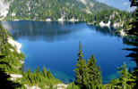
 On Tue, 8/6, we completed the Alternate Route, rejoined the regular PCT and ascended above Wapta Lake to Deep Lake for lunch. It was too windy for a swim. We were now in a beautiful Alpine scenery. There was a lot of traffic on the PCT and we encountered probably two dozen hikers, only few of whom were thru hikers. The trail ascends past Deep Lake, impressive Cathedral Rock (6,724') to above Hyas Lake and to Deception Pass (mi 2354) where a fine 19 mi day ended. The only exception was a tricky stream crossing at mi 2452 where my desert hat fell into the water and swept away into never never land.
|
 The next day,Thur, 8/7, started as usual at 6:30 am, except that Denise was gone. She suffered from her sprain. Most PCT hikers walk alone at their own pace, since it rarely matches that of others. I met her again at lunch. My tent was wet from condensation but would not dry since a cloud layer prevented sunshine. The trail passed by Deception Lake and climbed to Piper Pass (mi 2460) where it was time for an early lunch. Thereafter one hikes past Glacier Lke, Surprise Lke, Trap Lke to Mig Lke (mi 2468) which had a good camping spot before reaching Stevens Pass in 8 miles next morning. It was a relaxed evening in a scenic place with ample water supply.
 Fri, 8/8, was a cloudy day but luckily without rain. Starting at 6:30 am I passed Josephine Lke, pretty Susan Jane Lke, several forest clearings for high voltage lines, ascended the Stevens Pass ski lift terrain and hiked down to Hwy 2 at Stevens Pass. I crossed the new bridge over the busy highway and prepared for hitch hiking to Skykomish and Baring to the Dinsmore's Hiker Haven, a trail angels home for us. While waiting at the road a car came up and the driver was trail angel John Smith who frequently offers rides to the Dinsmores. He was so kind as to wait for Denise who just came down the trail. After the 23 mi ride we arrived in Baring at Andrea and Jerry Dinsmore's beautiful home and wonderful home for PCT hikers. My resupply parcel was there which gives peace of mind. After a shower, laundry and unpacking we headed across the train tracks and busy road to the Baring Store and Cafe for a delicious dinner at 5 pm in the company of other hikers and locals. In the evening I packed for next days departure while Denise took another rest day to recover from her ankle injury. The next destination, Stehekin, would be in 98 mi, passing through the heart of the North Cascades around Glacier Peak.
 On Sat, 8/9, we had once more a fine breakfast at the Cafe. Trail angel John gave several of us again a ride to Stevens Pass. What would the hike be without such goodwill? At 9:30 am I ascended the many switchbacks out of the valley toward Lake Valhalla (mi 2482), then over Union Gap to Lake James (mi 2486) for a late lunch and up to Grizzly Peak (mi 2490) which indicated a dry camp on the map. It turned out to be a small spot and already occupied and the next spot was in 8 mi. So I improvised a camp further along at mi 2491. It was fine weather, I had cell phone connection and enough water for my dinner and breakfast. There was also a fine view on Glacier Peak which the trail would visit soon.
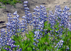
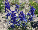
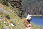
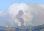
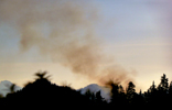
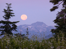
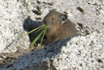
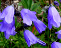
 On Sun, 8/10, morning I scraped the frost from my tent after a cold clear night at high altitude. There was a full moon which set just before the sun rose. I hiked down to Pear Lake which was off limits and found a note that access to Top Lake was closed due to the wildfire, whose smoke rose visibly to the east. I climbed over 5,000' Saddle Gap down to Cady Pass, reached snow patches above 5,500' near Skykomish Peak, but also came through meadows filled with lots of wildflowers. A cute pika posed for a picture. I met several nobo and sobo thru hikers. I stopped at pretty Lake Sally Ann for refilling water and a short dip into the lake but the water was bitterly cold with snow patches hanging into the lake. After lunch I continued via Dishpan Gap to Indian Pass (mi 2509) where I settled down after an 18 mi day. I had carried 2.5 l of spring water for dinner and breakfast to this dry camp. Prime mosquito season required life inside the tent. The air was hazy from the Chelan wildfires.
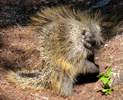
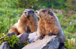
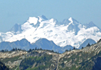
 On Mon, 8/11, I was up at 4:30 for a start at 5:30 am before sunrise. Before sunrise one can meet the wildlife. A porcupine came down the trail and was not shy approaching me within 6 feet, then turning back and climbing a nearby tree. Later two marmot youngsters were wrestling in a meadow. Got some nice pictures of all but the haze covered farther objects such as mighty
Glacier Peak. The trail was fairly level at high elevation crossing White Pass (5,904') and Red Pass (6,500'), then dropping down along the Chuck River to 3,866' mi 2522. I met a thru hiker who had already finished the trail nobo and now headed sobo to Mexico. Before ascending the Kennedy Ridge I stopped at Kennedy Creek. It has a broken but passable wooden bridge. I decided to camp on the flat sandy shore which looked like an ocean beach. It was a great place to relax in the hot sun, clean up in the cold water, cook and eat without being bothered by mosquitoes. Except for the noise of the wild river it was a great place to rest for next day's 2,000' climb.
On Mon, 8/11, I was up at 4:30 for a start at 5:30 am before sunrise. Before sunrise one can meet the wildlife. A porcupine came down the trail and was not shy approaching me within 6 feet, then turning back and climbing a nearby tree. Later two marmot youngsters were wrestling in a meadow. Got some nice pictures of all but the haze covered farther objects such as mighty
Glacier Peak. The trail was fairly level at high elevation crossing White Pass (5,904') and Red Pass (6,500'), then dropping down along the Chuck River to 3,866' mi 2522. I met a thru hiker who had already finished the trail nobo and now headed sobo to Mexico. Before ascending the Kennedy Ridge I stopped at Kennedy Creek. It has a broken but passable wooden bridge. I decided to camp on the flat sandy shore which looked like an ocean beach. It was a great place to relax in the hot sun, clean up in the cold water, cook and eat without being bothered by mosquitoes. Except for the noise of the wild river it was a great place to rest for next day's 2,000' climb.
 On Tue, 8/12, I awoke at 3 am by rain drops on my face. Since it was so warm I had not put on the fly which I now did in a haste. Some items got a bit moist but not really wet. I slept for another hour, then got up and traversed the broken bridge at 5 am. The rain faded out as I ascended the Kennedy Ridge, but the moisture on overgrown plants still made the shoes, socks and pants wet. The trail continued to 6,200' Fire Creek Pass, then descended on many switchbacks to icy Mica Lake and further down toward the East Fork Milk Creek, where my 17 mi day was over at mi 2540. The sky turned cloudy and this time I was prepared for a night shower.
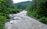
 Wed, 8/13, A thunderstorm with heavy rain moved in around midnight. In the morning I packed the wet stuff up and hiked with poncho in intermittent rain through fields of wet plants. Somewhere I missed a trail junction since I did not like to use the I-phone in the rain. When I talked to four nobo hikers they pointed out it was going sobo which was a bit embarassing but correctable. Amazingly, one lady ("Forgetmenot") remembered me from last year where we met at Kennedy Meadows in CA. My hike continued down to the mighty Suiattle River where I took the long detour to the new bridge which most people chose to do. The hike along wild river was very scenic but I took few pictures since rain and cameras are incompatible. Switchbacks started after mi 2353 and I climbed to the next waterhole at Miners Creek (mi 2558). I camped nearby after 18 mi of hiking.
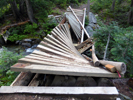
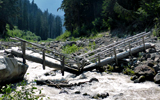
 On Thur, 8/14, morning it rained again. I packed and by 7 am ascended to Suiattle Pass. Then the trail dropped down to the Agnes Creek valley. Clouds swirled below and above, the trail full of puddles, lots of gushing creeks crossed the trail, the overgrown plants dripping wet and so was I. At lower elevations the Agnes Creek was a broad, deep and quietly flowing greenish river. When I arrived at the bridge indicated on the map there was a sign "Bridge Broken, Use Log Downstream". Indeed, it was there, maybe 100' long, wet and slippery. Cautiously I made it across. At mi 2576 the trail left the river and a mile later there was a nice campsite. The rain stopped for a while so that I could quickly set up camp, get water from Pass Creek, and cook dinner. There was no rush to continue hiking the last 5 miles to the High Bridge across the Stehekin River because the last bus to Stehekin Landing would be long gone. It would be better to arrive in the morning. Other hikers had the same idea and camped nearby.
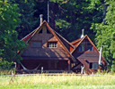
 Fri, 8/15, was the hike to the last and best town stop, Stehekin. I got up at 4:30 am since a mouse kept me awake from midnight to 3 am. Every half hour I heard a chewing sound and chased it away, but without much success. In the morning I saw the hole in the food bag and a plastic bag, luckily the trash bag, since I was nearly out of real food. In the early morning hours I hiked in a drizzle gently up and down until steep switchbacks dropped down to a first bridge across Agnes Creek and a second bridge over the much bigger Stehekin River. I arrived at 8:30 am for the 9 o'clock bus which came punctually. In the meantime many other hikers showed up and filled the bus. It made several stops, first at the Stehekin Ranch, then the famous bakery, and a fine organic farm, and finally the Landing where the Lodge and P.O. were. I could not get a room in the Lodge, but got at least my last resupply parcel. Took the next bus back to the Ranch where I got a place to stay for two nights. It was a log cabin, a little house in the prairie, one wooden bed, an oil lantern, a wooden door which did not close, I washed my laundry by hand, there was a bear sighted at the Ranch and next day I found a bear pie near my cabin, thus it was a touch of the good old times. But there was comfort, too. All Ranch guests were served three delicious meals a day, free bus travel was provided, bike rentals were available, etc.
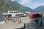
 Sat, 8/16, was a zero day. Everyone said that this is a must and I fully agree. Stehekin is beautiful, the people are nice, there are places to spoil you such as the bakery and organic garden, and the Lodge allowed me a phone call home since no cell phone connection existed. In the morning I rented a bike at the Landing, on a pay-later honor system, and biked along Lake Chelan and Stehekin River for 10 mi to the High Bridge. Had sweet goodies in the Bakery, peaches and nectarines at the Organic Garden and took many pictures of the beautiful valley on a sunny day. This day was a perfect relaxation for the last stretch of 89 miles into Canada.
 Since I like early morning starts I skipped on Sun, 8/17, the Ranch breakfast, walked the 2 mi to the High Bridge and was back on the at at 6:15 am. The trail ascended past Coon Lake, entered the official North Cascade National Park, followed the wild Stehekin River to the confluence with the Bridge Creek, crossed a bridge and continued along Bridge Creek. The crossing of Maple Creek (mi 2590) was tricky and aided by a ponton bridge. The campsite at South Fork was for equestrians and not for my taste. At mi 2596 the trail leaves again the National Park. A mile further it crosses the Bridge Creek, another balancing act on logs. There were decent campsites near the creek where I settled down just before the evening thunderstorm started. What else would one expect near Rainy Pass? While it rained and thundered outside I had a mashed potato and chicken dinner inside the tent. It was a pleasant day where I met several backpackers and a youth outdoors group but no PCT hikers.
On Mon, 8/18, I hiked at 5:45 am toward Rainy Pass. Tent, shoes and clothes were wet. It was cold and misty as I passed over Hwy 20. The official Rainy Pass was just a flat region in a forest. Cutthroat Pass (6,840') was a real pass, reached after ascending 2,000' of switchbacks. No pain, no gain is true: On the top there was a wonderful view of the North Cascades toward Canada.
 Other hikers also enjoyed this scenic spot. After taking many pictures I continued to Granite Pass for a lunch break and drying of wet gear before clouds covered the sun. In the afternoon I followed the trail to Methow Pass (mi 2610). Switchbacks brought me down to the Methow River with a nice campsite at a bridge at mi 2615. That's where I stayed at 5 pm after an 18 mi hike. Thru hiker Tom joined me, others just passed by. For a change, there was no thunderstorm or rain, just nice summer clouds.
 On Tue, 8/19, it rained in the night from 3-5 am. By 6 am it stopped and I got up, packed and hiked out at 7 am. The trail reached and followed Brush Creek, then switchbacked up to Glacier Pass (5,550', mi 2620') and continued along a ridge. At mi 2624 I filled up 2.5 l of clear spring water since a dry stretch of 21 mi was announced. The trail continued past Tatie Pk to Harts Pass (mi 2630). Near the Pass day hikers gave me an apple and a power bar. Too many cars and people made me to continue the hike toward Slate Peak which has an abandoned Lookout Tower. Continuous slopes made it difficult to find a campsite, but eventually I found one at mi 2634. There were lots of clouds in the sky and a cold wind blew, but luckily it did not rain.
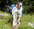
 Wed, 8/20,. I did not sleep well since someone pushed on my tent at night. It must have been a curious deer since a bear would have gotten in to grab my food bags which I always kept inside. I got up at 5 am and hiked before sunrise to see the pretty sky colors before the sun is too bright. I ascended lots of little passes such as Buffalo P., Windy P., Foggy P., Jim P. and eventually Holmann P. Two couples with 2 llamas came sobo and I asked many questions about their experience. Llamas are very different from horses, make good hiking companions, need little food and water and carry 75 lb packs easily.
Wish I had gotten one earlier.
Wed, 8/20,. I did not sleep well since someone pushed on my tent at night. It must have been a curious deer since a bear would have gotten in to grab my food bags which I always kept inside. I got up at 5 am and hiked before sunrise to see the pretty sky colors before the sun is too bright. I ascended lots of little passes such as Buffalo P., Windy P., Foggy P., Jim P. and eventually Holmann P. Two couples with 2 llamas came sobo and I asked many questions about their experience. Llamas are very different from horses, make good hiking companions, need little food and water and carry 75 lb packs easily.
Wish I had gotten one earlier.
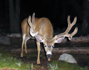
 After a few miles I reached Rock Pass (6,491', mi 2649), below which a trail maintenance crew was repairing the damage from washouts. I thanked them for their hard work of making our hike easier. After dropping a couple hundred feet the trail ascends to the last high pass, Woody Pass (6,643'). It still had a snow patch on the top. Hard to believe, Canada was only 6 miles away and in clear sight. From now on the trail was mostly downhill. At the Devils Staircase the trail drops down to pretty Hopkins Lake (mi 2654). It was a fine place for a last camp after this 20 mi day. Three other hikers camped also there. At night a buck visited the vicinity of my tent and I got a nice portrait of him.
 Thur, 8/21,. As usual, I got started hiking around 6 am. After Hopkins Pass the trail became overgrown with wet brush. Shoes, socks and pants got wet up to the hips. The sky was grey and the Alpine scenery was over. After crossing over minor Castle Pass it was clear sailing to the border. I arrived alone, nobody in sight, no joyous thru hikers partying. When seeing the Northern Terminus I did not know whether to feel joy or sad. It had been a long walk, and now it was over, almost. Compared to the ugly wall at Campo the border was just a clearing in the forest, a sign of openness.
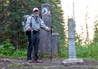
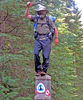
 Monument 78 was a segmented brass cylinder. It had to be disassembled to get to the PCT register book placed inside. Many pages full of hikers facts and feelings were recorded. So I added my story too and closed everything. Just before leaving two, then three other hikers arrived. Now we had a quorum to express ourselves. Jeff was a genuine thru hiker this year, his companion finished the WA section, three friends were shorter section hikers, and I completed the trail in two years, CA in 2013, OR and WA this year, not too bad for an "Opa" at 74. We reminisced, took pictures, Jeff balanced with one leg on the Terminus and we all had fun. Three of us headed for Canada, three returned to the USA.
 My daughter Ana was a keen outdoors person who loved hiking. She would have loved to do this hike, but her trail ended last year. I carried some of her ashes to the end of my hike to fulfill her wish.
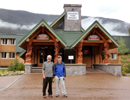 There were still 8 miles of well maintained PCT in Canada. It climbed close to Windy Joe Mtn, then descended to Manning Park on Hwy 3. We checked in at the Lodge, went through the usual chores of laundry, shower, battery charging, etc. I reserved a bus next day to Vancouver. Jeff was to be picked up by his wife from Seattle. He graciously offered Lance and me a ride to Seatac Airport from where Lance would fly to Portland and I to San Francisco. We celebrated the end of the trip with a fine dinner in the Restaurant.
Sunday came, no car came. To make the story short, Canadian border control found out that Jeff did not have the proper entrance papers and delayed her entrance and his exit from Canada. One never knows what comes up next on a PCT hike. But all trails have an end. I caught the last flight to SFO and was home on Thur midnight and I am sure everyone else made it home too, although Jeff had quite a story to tell lateron.
Some months have gone bye when I added this paragraph. Reflections of the hike are coming up again and again. While details may get lost the main conclusions have become clearer. "Why did you hike for so long", asked my 4-year old granddaughter. "Because I like to see beautiful nature", I told her. But perhaps there is a bit more to it. I wanted to return to many places where I have climbed or skied before, I wanted to see new places, I liked to meet new people with the same values, and I still felt strong to do all this.
In time the pains seem to fade faster while the happy moments stay. The view over miles and miles of mountain ranges is unforgettable. The feeling that one has walked 1000, 2000 miles and is still going strong is wonderful and builds self esteem. The feeling of freedom on the trail is so different from "normal" life. Life is simple, yet one has to watch out for the basics like water, food, health, weather, shelter, meeting others to stay emotionally healthy, etc.
My hike through OR and WA was planned differently from my first thru hike mentality in CA. I wanted to enjoy the trail and mountain sceneries, thus chose mid summer to avoid the Sep/Oct cold rains and snow up north. I loved to take pictures of meadows full of wildflowers, the long days, dips into lakes, tasting the berries, meeting many section hikers, sobo and nobo thru hikers and even one fast flip-flopper.
 I learned from earlier mistakes to take care of my body and treat it well like my old car engine, fill it, lube it and don't drive it too fast. Never had a blister or any disabling injuries, which I am so grateful for. Thus the trip was a wonderful start of my retirement life and I am thankful to all who supported me, my family, friends, trail angels, trail maintenance crews and the PCTA which sent me this nice congratulation poster for the trip completion.
Go back to Part 1
Go back to Part 2
Go back to Part 3
Go back to Part 4
Back to Trip Reports
Back to SMS Home Page
|
