|
This is a continuation of the trip report "Pacific Crest Trail-Part 1: Southern California" and "Pacific Crest Trail-Part 2: The Sierra Nevada" and "Pacific Crest Trail-Part 3: Northern California". This report describes the trip through Oregon, i.e. from Calahans to Cascade Locks. Click on "Pacific Crest Trail-Part 5: Washington" to find the completion of the PCT hike.
Although thru-hiking is the goal of many PCT hikers it is not always possible as planned. In my case a family emergency required me last year to end my hike in Southern Oregon. But I vowed to come back and finish it next year and this is what I did in 2014. In early summer I hiked through Oregon, in mid-summer through Washington to Canada. Two reports describe these trip adventures.
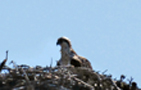
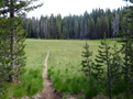
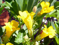
 Family members gave me a ride from San Francisco to Calahans where the PCT crosses Interstate 5. On Sun, 6/22, I started my hike at 10:30am, accompanied by my second daughter Isa and her dog for a few miles. It was a wonderful day with sunshine, meadows full of wildflowers with pretty butterflies, birds singing, an eagle in the air, just as imagined for summer solstice. But wait, the best plans of men and mice don't always work. I had thought that early summer would be ideal for OR and WA but did not know that this year summer came late. The result was lots of snow travel around the volcanoes, travel in rain was common and blueberries were rare. But more details later.
By midday my daughter returned to join the rest of the family for a performance of the Shakespeare festival in Ashland. I continued my hike, crossed Hwy 66 and covered 18 mi on the first day due to the late start.
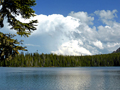
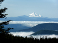
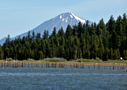 On Mon, 6/23, I was on the trail by 6:30am heading for Hyatt Reservoir where I made a detour to the Resort to pick up my first resupply packet. After a sumptuous breakfast I returned to the PCT which circles around the long lake. Before leaving the lake I stopped for a swim and early lunch. The view of the blue lake with Canadian geese and the volcano Mt McLoughlin on the horizon was inspiring. Then I continued toward Howard Prairie Lake where I tanked 4.5 l of water at the campground for an upcoming dry camp. The trail ascends and around 6 pm I found a fair campsite beyond a dirt road at trail mile 1760. It was another 18 mi day due to the resupply detour.
 On Tue, 6/24, I was up at 5:15 am for a full day of hiking which started with a good climb. At a spring (mi 1762) I met a young hiker George whom I had seen near Calahans. I would later meet him on and off till the Columbia Gorge, his destination for this year. At midday I reached the Brown Mountain Shelter (mi 1770) where I had a lunch break and water refill. As is quite common one meets other PCT hikers at such water "holes". This one had a pump which required some vigorous pumping to get the well water into a bottle.
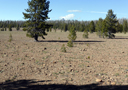
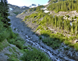
In the afternoon I continued hiking partially through dry lava beds of Brown Mtn towards Hwy 140 which leads to Fish Lake. I had no need for a resupply detour, so I found a nice campsite near a nice creek from Mt McLoughlin at mi 1781. This was a "normal" day of 22 mi for me.
 On Wed, 6/25, I was hiking by 6:15 am. The sky was grey and clouds were sinking. By 10 am it started to drizzle. It rained at Christie Springs where I refilled water. This was not a short shower. Rain continued past Red Lake beyond Sky Lake where it began to snow and I hiked in a whiteout. What a difference a day makes! At 5 pm it looked already dark. In an open forest I found a suitable campsite (mi 1800) and set up the tent in the rain. By 7 pm I was dry and warm in my sleeping bag while the rain drops made a nice sound on the tent fly. I thought that this must be an introduction to the northern states.
Thur, 6/26: It rained all night long and continued in the morning. I was considering to wait out the storm but got restless lying in the tent. By 9:30 am I got up, packed all the wet gear and headed out an hour later. The trail climbed to a 7,200' ridge over Shale Butte and Devils Peak but all I could see were nearby trees and clouds beyond. The descent from Devils Peak was on steep snow fields. I was tired of carrying water in the rain and therefore had to press on to the next water hole, Jack Spring (mi 1817). It was reached by a 1.3 mi o.w. side trail, but the clean spring water was worth the effort. By 7 pm I set up camp near the PCT. It rained again in the night.
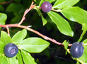
 Fri, 6/27, was a deja-vu. Rain in the morning, a cold breakfast in the bed, at 8 am packed up the wet and heavy gear and hiked out by 9 am in intermittent rain. Shoes and socks were soaking wet from trail puddles and touching dripping wet plants. But the good news was that the rain subsided during the day. The trail became flat and through open dry forest in the "Oregon Desert". After reaching Hwy 62 it was only a short walk to the Mazama store to pick up a resupply parcel, to the restaurant for a good meal and to the campground for a nice tent site. Laundry was done and the day ended with a fine dinner with other hikers.
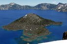
 On Sat, 6/28. Once more, what a difference a day makes! After 3 days of rain there was not a cloud in the sky. I met George again and we hiked together to the Rim Village. What a wonderful sight was deep blue Crater Lake in sunshine. We had a breakfast together and filled up 4 l water since the Rim Trail and beyond had none. The Rim Trail was very scenic and very popular among the many visitors who came by car to the Park. There was still plenty of snow on this high trail (>7,000'). At times we walked the Rim Road instead of the snow covered PCT which goes parallel to the road. After walking many miles on Hwy 209 we rejoined the PCT where equestrian and hiker trails come together (mi 1844). After many miles of hiking on a sandy trail with lots of downed trees we camped at 6:30 pm in a small forest clearing (mi 1849). It was a 20 mi day of carrying a heavy pack with new resupplies and lots of water. All night long the forest made a moaning sound when the wind rubbed dead trees leaning against their supporting neighbors.
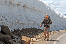
 On Sun, 6/29, as an early bird, I was up at 5:15 am while George preferred a later start since he walked faster. I hiked to busy Hwy 138c with traffic to Diamond Lake and then continued the PCT toward Mt Thielson. Soon snow covered the trail. This was particularly tricky on steep forest trails where the sun did not soften the snow. When the snow hangs over the trail the slope of the snow can be as steep as the ambient slope such that a fall would have serious consequences. Thus, it was occasionally better to climb above or below the snow field which was very tedious. Intermittent snow coverage posed no route finding problems but slowed down the hiking progress. On the other hand, on large snow fields one cannot see the trail without following a GPS guidance. It is possible to follow footprints but they can be difficult to discern on frozen snow, they vanish in intense sunlight and they may belong to non-PCT hikers. Although the I-phone GPS and Guthook app are completely reliable its continuous use depletes the battery lasts in a day. A backup battery or solar charger are needed. The electronics has to be carefully protected from moisture, cold temperature and any accidental damage, thus as a backup I always carried Half Mile maps and a small compass.
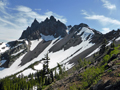
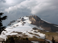
I met some local hikers at the junction of the PCT with the Thielson trail, but nobody was attempting the peak ascent which looked like class 4 terrain. I was tempted to try it but refrained from it since an injury could easily scrap the main goal to hike to Canada. So I continued in that direction until 6:30 pm, passed the trail high point for OR and WA (7,560') near Tipsoo Peak (mi 1866) and soon found a nice campsite free of snow.
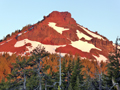
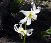
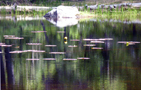
 On the next day, Mon, 6/30, I was up before sunrise which is often the best time of the day. The mountain peaks turned red on a cloudless morning. I hiked past Miller Lake and Maidu Lake, unfortunately the trail does not touch the shores for a swim. I did a side trip to Six Horse Spring to refill water, but it was better suited for horses than humans, thus I filtered the water. Past Tolo Mtn I had a snack break and a lunch break at Windigo Pass. There I decided to take the Oregon Skyline Trail Alternative which avoids the long snow travel around Diamond Peak. Both trails go to Shelter Cove at Odell Lake, but the PCT involves a lot of snow travel while the alternative trail is more scenic with lots of lakes. Thus I headed in the direction of Oldenburg Lake but at 5:30 pm I decided to stay at Nip and Tuck Lake (mi 1886) to enjoy a swim and relaxed dinner time. Only the mosquitoes spoiled the good times which required an early retreat into the tent.
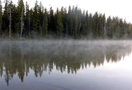
 On Tue, July 1, at 5:30 am the lake had was covered with a fog layer since the air was cool and the water still warm. The hike past Oldenburg and Bingham Lakes went fast and I reached Crescent Lake but bypassed the campground. I continued along the road around the lake to the Whitefish Horse Camp where I filled up fresh water. The alternative trail continues along Whitefish Creek to Diamond View Lake, properly named for the fine view of snow covered Diamond Peak. After a short dip into the lake I continued along Trapper Creek to Odell Lake. The Shelter Cove Resort had my resupply parcel and HEET for my stove, but for dinner only a hot dog with beer. There was one place left in the campground which was otherwise filled with RVs and camper cars. At night lightning, thunder and rain moved through.
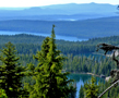
 Since the Resort opened at 8 am I skipped the breakfast on Tue, 7/2, and walked 2 mi around the lake to Williamette Pass where the PCT crosses Hwy 58. The ski terrain was clearly visible. I passed the Rosary Lakes at 8 am, filled up water and continued to Bobby Lake where I stopped for a short dip. Thunderstorm clouds were growing. The trail goes parallel to and well above the long Waldo Lake. But it touches Charlton Lake (mi 1938) where my hiking day ended after 19 mi on the trail. I had the lake for myself and a wonderful campsite near the water. Cleaned up, cooked, ate dinner inside the tent which kept the mosquitoes out. There were some clouds drifting in but no thunderstorm activity like last night.
On Thur, 7/3, I woke up in dense fog. Condensation made all exposed surfaces wet. I waited till 8 am when the sun broke through and dried out the gear. By 9 am I headed out to Taylor Lake, took a dip, continued to Brahma Lake for another dip, then to Storming Lake (6,045') for a very short dip since the water was ice cold. Above 6,000' elevation there was still plenty of snow. Finally, the day ended with a last swim in Desane Lake (mi 1948) where I set up camp with lots of mosquito friends. If it was not for them the lake district would be truly gorgeous. All day long I met only two sobo section hikers. I did not cover much milage (16 mi) but had a great time on this fine summer day.
 On Fri, 7/4, it was only a short distance to reach my next resupply place at Elk Lake. Starting at 6 am I continued the hike through the "Lake District" with an endless number of named and unnamed lakes. This time I skipped the dips and was at 11 am at the side trail to Elk Lake. At the Elk Lake Resort I got my resupply parcel but no cabin was available. As a consolation I ate a rich burger with beer. So it was back to camping again. At least I could shower, wash my clothes, charge all batteries, phone and e-mail. Strangely enough, there were no July 4'th celebrations at or on the lake.
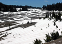
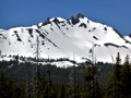
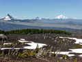
 Sat, 7/5, was another fine day. The destination were the Three Sisters. By 6 am I walked from Elk Lake along the road to Horse Lake Trail which joins the PCT at mi 1960. Many pretty lakes were encountered in the high country (mi 1965, elev 6,000'). Several tents and day hikers could be seen. As one approaches the South Sister one encounters a large lava wall ("Rock Mesa") to the right and a wide open plane to the left ("Wickiup"). By early July there were large snow fields on the plane but good tracks and some cairns helped with the navigation. Then the trail meanders again through forests which makes route finding more difficult and time consuming.
|
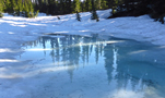
A GPS with enough battery power is the best solution. I walked on snow till 7 pm and then camped on a short snow-free section of the trail between the South and Middle Sister at mi 1975. The battery indicator read 40% and it was still a long way to get around the North Sister. Luckily I had a solar charger with internal battery. I recharged the I-phone overnight inside the warm sleeping bag and was ready for another day of snow travel. The night was cold, calm and the sky was clear and full of stars. No humans anywhere in sight.
 On Sun, 7/6, I got up at 6 am and left an hour later so that the sun could soften the top snow layer, otherwise one slides easily on sloping snow fields. Hiking with a GPS and hiking poles on sun-cupped snow is not so easy. Furthermore, sunlight and snow reflections are so bright that the
GPS screen is hardly readable. Of course, one should not accidentally drop the GPS on a rock.
On Sun, 7/6, I got up at 6 am and left an hour later so that the sun could soften the top snow layer, otherwise one slides easily on sloping snow fields. Hiking with a GPS and hiking poles on sun-cupped snow is not so easy. Furthermore, sunlight and snow reflections are so bright that the
GPS screen is hardly readable. Of course, one should not accidentally drop the GPS on a rock.
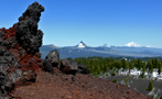
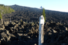 By 9 am I reached the Obsidian protected area just west of the North Sister. It is a protected area with special rules to preserve the beautiful obsidian rocks. I almost took a fall on a snow covered obsidian rock which is as slippery as glass. There is also a sizable waterfall to refill water bottles. Further north cinder fields and lava beds mix with snow fields. Lava beds dominate the landscape where the PCT crosses Hwy 242 at mi 1990. It is an eery landscape, almost lifeless, nearly impassable without a trail. The PCT is well built with smaller red gravel than the big chunks of sharp porous black volcanic rocks which grind down most shoes. Before traversing the highway there is a nice campsite at Lava Camp Lake, where I stayed for the night. The water was warm and the lake invited for a swim. Just the same story as before: Swarms of mosquitoes descend upon you unless one is under water or inside the closed tent which I did. I ate inside the tent and retired by 8 pm.
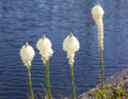
 On Mon, 7/7, I hiked at 6 am to MacKenzie Pass across Hwy 242, climbed past the Belknap Cinders, crossed snowfields above 6,000' and got into vast areas of burnt forests. Broken trees have not been cleared from the trail which requires hikers to climb over or under or around the logs. Bear grass and lupins flourished in burnt forests with ample sunlight. The space between the dead trees opens the view on volcanoes such as nearby Mt Washington. I passed the 2000 mile mark but found no sign to that affect on the trail. Then I came to the trail to the Big Lake Youth Camp (mi 2001, 4644') to where I had sent a resupply parcel. It was there and I felt reassured for continuing to hike for another week.
 I met George again at the Youth Camp. The Camp had a young leader to care for PCT hikers. She offered us meals, shower and laundry place, a place to sit, repack and take care of our electronic needs, much more than our donations covered. We had nice conversations with some of the youth counselors. Because of the youth groups we could understandably not sleep at the Camp and stayed at nearby campgrounds. I camped at the lake shore in the nearby Cove. Water and air were warm and inviting for a last dip.
 On Tue, 7/8, I waited for the sunshine to dry the condensation on the tent, then joined breakfast at the Camp and finally was on the road at 9:30 am. In two hours I was at Sentiam Pass on Hwy 20 (mi 2007), then started the trail toward Three Fingered Jack. It did not take long to hike again in the snow, but mostly on the north facing slopes. The trail descended toward Wasco Lake but stayed well above its shores. On the other hand there was a small unnamed lake at mi 2018 near the trail which was good enough for a camp at 5:30 pm. Took a cleaning dip into the lake and set up tent at some distance from burnt trees. I still remember the scare which I got at night when a tree came crashing down. After sunset I noticed cirrus clouds were moving in and hoped the good weather would hold up.
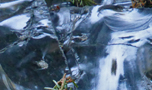
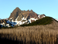
 On Wed, 7/9, I was up at 4:45 am, did the usual chores and hiked out an hour later. Refilled water at Rockpile Lake (mi 2022), traveled the 6,000' ridge between South and North Cinder Peaks mostly on snow , refilled water at Shale Lake (mi 2030) which was half filled with snow. With GPS I navigated on trackless snow towards the next big volcano, Mt Jefferson. The trail descended to Milk Creek, a powerful silt-laden stream from Jefferson's glacier. Wild rhododendron was blooming near the trail. Since it is best to cross glacial streams in the morning I decided to stay at one of the nearby campsites (mi 2035), later joined by hiker friend George and two other section hikers. I had stimulating discussions about energy and environment with these young, intelligent college graduates.
On Thur, 7/10, I forded Milk Creek without difficulties, ascended and refilled water at the clear Jeff Creek. Then came another tricky fording of Russell Creek and miles of snow travel past Russell Lake (mi 2042) to Breitenbush Lake (mi 2047). Two hikers ascended from that lake so that I could follow their footsteps instead of my GPS. The snow petered out below 5,000' elevation and travel was easier. When the forest opened up one could see Mt Adams, St Helens and Mt Hood. There was a nice campsite at Upper Lake (mi 2051) where I settled for the night. Swarms of mosquitoes were the only companions that evening.
 On Fri, 7/11, I left at 5:30 am to beat the mosquitoes, but it was in vain. I hiked down to Olallie Lake for a nice breakfast, but in vain, the store was still closed. So I continued on the trail feasting on powerbars. The trail passed by pretty Jude Lake (mi 2058). A sobo thru hiking girl passed by. Refilled water at Lemiti Creek (mi 2063), hiked around the Pinhead Buttes down to a spring at mi 2072 where cold and clean water tasted so good. A couple of miles more got me to Warm Springs River (mi 2074) where by 5:30 pm I decided to camp since the next water hole would be 10 mi away. It was one of the rare times that there were no mosquitoes around. After the 23 mile day I slept well, except for a rude awakening at night when nearby a tree collapsed. It felt like a bomb exploded.
 Sat, 7/12, was another 23 mi hiking day. Starting at 6 am I headed in the direction of Mt Hood. I passed by the Summit Butte (mi 2077), reached Timothy Lake (mi 2086) by midday, where there were many tourists due to the easy access by car. After a short dip I continued past Crater Lake, ascended the slopes of Basin Point, drank spring water at mi 2093 and reached Frog Lake campground (mi 2097) at 6 pm. All official campsites were taken by RVs and campers, but I found a gap to squeeze in. The special event of the day was a 50 mi ultra marathon race on the PCT by many, many participants, young and old, men and women, all greeting kindly and passing by. Nice contrast to the days alone on the trail.
I was looking forward to a short hike next day to Mt Hood.
Sat, 7/12, was another 23 mi hiking day. Starting at 6 am I headed in the direction of Mt Hood. I passed by the Summit Butte (mi 2077), reached Timothy Lake (mi 2086) by midday, where there were many tourists due to the easy access by car. After a short dip I continued past Crater Lake, ascended the slopes of Basin Point, drank spring water at mi 2093 and reached Frog Lake campground (mi 2097) at 6 pm. All official campsites were taken by RVs and campers, but I found a gap to squeeze in. The special event of the day was a 50 mi ultra marathon race on the PCT by many, many participants, young and old, men and women, all greeting kindly and passing by. Nice contrast to the days alone on the trail.
I was looking forward to a short hike next day to Mt Hood.
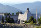 On Sun, 7/13, I started by 6 am on a cloudy day. By 9 am I heard the first thunder in the sky. When I crossed Hwy 35 I chatted with a traveling couple who were very kind to PCT hikers and gave me two fresh bananas. Such goodwill remains in memory for a long time. As I approached Mt Hood from the south it became very windy and the wind approached a desert dust storm. The fine dust got in everywhere, nose, mouth, hair, clothes. By noon I was relieved to be in the Timberline Lodge (mi 2107), a historic, elegant building. There were hundreds of visitors who came by bus and cars to visit this site and to ski on the mountain. Not surprisingly there was no room available. I got on the waiting list for possible cancellations and was lucky to get a last fancy and expensive room which spared me from camping in the dust. I had a late buffet lunch and then drifted into the Blue Ox Bar for a beer. It was packed full and everyone was staring at the TV. Just by sheer coincidence I enjoyed to see the world soccer championship won by Germany. I sat together with hiker friends, George among them, and we had quite a few beers and pizza. Later on, I called my family, and did the usual chores of laundry, showers, resupply parcel, battery charging and e-mailing. From my room I had a fine view of the mountain and saw the groomed ski area with lifts, the large crevasse below the Pearly Gate where we once climbed the summit and telemarked down below the crevasse.
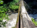
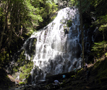 On Mon, 7/14, the hike around Mt Hood continued. I left the Lodge at 7 am, hiked up to the PCT and under the ski lifts where lots of young people were riding up to enjoy skiing down. The trail passed through Zig-Zag Canyon, Lost Creek, Rushing Creek and Sandy River, which required fording through the cold rushing glacier stream with full gear, water nearly up to the hips. Bridges over these wide river beds do not exist since they would not survive the seasonally heavy water and snow loads from glaciers. After a clean up and lunch I continued the hike with a detour along the Ramona Falls Alternate. It is a beautiful and popular trail with an impressive waterfall at the end. The trail is in a green canyon covered with moss and fern, following a gushing stream, all indicating an abundance of moisture. The trail rejoins the PCT at Muddy Fork which requires a trail crossing on a log that fell across the creek. The PCT climbs the slopes of Bald Mtn and then continues to Lolo Pass (mi 2125) where there were campsites and with ripe blueberries and salmonberries.
 On Tue, 7/15, I left at 6:30 am and climbed the ridge east of Bull Run Lake and Blue Lake which are in a protected watershed area for the City of Portland. The trail continues to Indian Springs (mi 2138) where I had a late lunch or early dinner. It is the beginning of the Eagle Creek Alternate Route which most PCT hikers choose. Thus, it was appropriate to spend the night there and do the 17 mi alternate route to Cascade Locks on the next day. The campsite was nice, there was running spring water, and other hikers joined like George and an English-Irish couple who were thru-hikers.
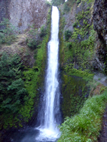
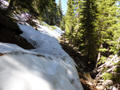
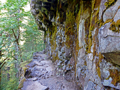
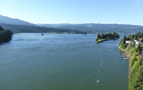 This day, Wed, 7/16, would be the last day of hiking in Oregon. As usual around 6 am, first down the steep Indian Trail, then the well maintained Eagle Creek Trail. Near Tunnel Falls the trail is an engineering marvel, being blasted out on a vertical rock wall and through a tunnel behind a large waterfall. Beside Tunnel Falls there are other water falls, many calm swimming holes and quite a few dangerous water slides. There are eagles flying over the Eagle Creek. The lower trail is pretty but a bit overused from day hikers starting at a trailhead near Hwy 84, elev 253'. A 2 mi road walk gets one into Cascade Locks near the Bridge of the Gods that spans the Columbia River. I checked in at the Best Western near the Bridge and got a nice room. My resupply parcel was found at the renamed Pub and Hostel, HEET was found at the nearby Chevron Station, so that I was ready for the next hike in Washington. I had an oversized 2000 cal burger at the Charburger, bought some delicious peaches and cherries at a fruit stand near the Bridge, did my laundry, showered, met George and the thru hiking couple, phoned and e-mailed, walked on the Bridge where a film crew was busy filming scenes for the upcoming movie following Sheryl Strayed's bestseller "Wild". The Bridge is part of the PCT.
Go back to Part 1
Go back to Part 2
Go back to Part 3
Go forward to Part 5
Back to Trip Reports
Back to SMS Home Page
|
