|
This is a continuation of the trip report "Pacific Crest Trail-Mexico to Oregon, Part 1: Southern California". The earlier general comments will not be repeated here.
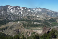
The PCT hike in the High Sierra poses new challenges. There are high passes to climb, significant snow fields to traverse, route finding challenges in mixed rock and snow terrain, swift cold streams to cross, fewer supply places and no caches. On the other hand there is no shortage of water and no desert temperatures, in the contrary one has to be prepared for freezing temperatures and occasional snow storms.

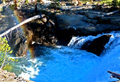
 After a good rest at K.M. I started on Wed, 5/22, at 5:30 am to hike north along the Kern River, ascended into Cow Canyon and on to Olancha. After hiking 20 mi with a heavy pack I set up camp at Olancha Saddle at mi 724. Since I had climbed and skied Olancha before revisiting this area brought up nice memories. This was repeated many times in the Sierras where I had climbed over 300 different peaks and skied many backcountry routes.
On Thur, 5/23, I continued north from the Olancha Saddle. There were great views to the east into Owens Valley, to the north to the high peaks of the Kaweahs, and to the south over the peaks of Sequoia National Forest. I passed Gomez Cyn, filled up water at Death Cyn Creek, Ash Creek and Diaz Creek. Snow added to the gatorade drink provided pleasant cooling. But after my usual 20 mi I was tired from carrying the heavy pack over 11,000' ridges. I camped at mi 742 near Diaz Creek with not a soul around. It was bear country and I could not stuff all of my food into the bear box. Luckily, I had no visitors at night.
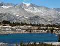
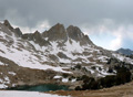
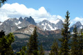
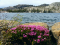
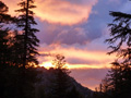
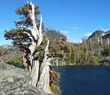
 On Fri, 5/24, my water bottle was frozen again. What a change to SoCal! I hiked to Mulkey Pass, Trail Pass, Cottonwood Pass and had lunch at Chicken Spring Lake, the first pretty Sierra lake. Although easily accessible from Horseshoe Mdws there was nobody at the lake or on nearby trails. I enjoyed to revisit this area where I have climbed and skied so many times before. The trail continues to beautiful Rock Creek but the PCT deviates via the Siberian Outpost to the lower Rock Creek. I set up camp near the river. It was a fine day with views of high peaks, green meadows, gushing streams and new wildflowers. But in the afternoon high cirrus clouds moved in which often signal a change in weather in a few days.
 On Sat, 5/25, I was entering the real high country. Beyond Crabtree the Pacific Crest Trail joins the John Muir Trail. From the Lower Crabtree Meadow I headed to Wallace Creek, Wright Creek and Tyndall Creek. I forded four major streams without incident. But I bypassed the detour to Mt Whitney since I had climbed it five times before.
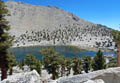
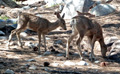
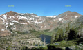
 I enjoyed the great views of the Great Western Divide and the Kaweahs from Bighorn Plateau. There were deer in the green meadows below high peaks. I took many pictures of this scenic terrain. I camped at mi 760 which is about 5 mi from Forrester Pass such that I would ascend it tomorrow by mid morning when the snow is firm yet not frozen. At night the temps dropped again below freezing such that next morning my washed socks were stiff like a board but not dry.
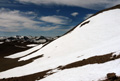
On Sun, 5/26, I crossed Tyndall Creek and began the long ascent of Forester Pass. The trail detours far to the right (east) side of the obvious chute, then crosses the snow field to the left side where switch backs lead to the top. Due to the low snow coverage crampons were not needed. At 10 am I reached the pass and enjoyed the great views. Other hikers came up. It felt good to have made the highest point of the PCT (Whitney is on the JMT, but not the PCT). Then I descended the gentler north slopes which had more snow coverage and occasional postholing by midday. Due to the snowmelt Bubbs Creek was running strong. Center Basin was very scenic. The view back on the Kings-Kern Divide brought up memories of climbing Mt Stanford or skiing Mt Keith.
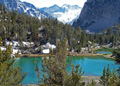
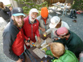
 At Vidette Meadows I left the PCT and took the side trail to Kearsarge Pass via Bullfrog Lake to resupply in Independence. The scenery at the lower Bullfrog Lakes was spectacular: The lakes were bright green due to the silt from the snowmelt. I camped at the scenic Kearsarge Lakes with the background of the rugged Kearsarge Pinnacles. Next morning, 5/27, it was a straightforward hike over Kearsareg Pass where I met more PCT hikers and then we dropped down to Onion Valley where I hitched a ride to Independence. I checked in at the Courthouse Inn where a resupply parcel waited for me. We feasted on Subway sandwiches and a salmon burger at a French-like restaurant. I also visited the local Museum, saw the home of writer Mary Austin after whom a mountain (Mt Mary Austin) is named, and stopped by a climbers friend's home but they were in Dubai instead of Independence. Next day, 5/27, was a zero day since the next section to Edison Lake would be a long one.
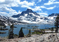
 On Wed, 5/29, we organized an early transportation to Onion Valley at 5 am to get a good start. But overnight clouds moved in and we were in a whiteout and snowstorm as we crossed Kearsarge Pass. The winter weather continued until we ascended Glen Pass where the storm clouds broke up. While there was nearly no snow on the south side of the pass the snow fields on the north side continued almost down to the Rae Lakes. Initially it was a steep descent but we had good tracks. The Rae Lakes were very beautiful and not crowded as is common in mid-summer. I continued to Woods Creek where other hikers joined. There were bear boxes so that we had a safe night's sleep. Including the Kearsarge trail it was a 20 mi day with a 11,800' pass and a winter-like storm.
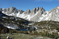
 On Thur, 5/30, my plan was to hike over Pinchot Pass into the upper Basin close to Mather Pass so as to avoid postholing on its north side in the afternoon. After crossing the wild Woods Creek on a swinging suspension bridge I reached Pinchot Pass by 12:30 pm still in time to avoid postholing on the large snow fields on its north face. The trail drops down to the Kings River, which I crossed on logs and then started the long ascent into the Upper Basin. I camped at the last established campsite near the tree line at mi 813, elev. 10,700'.
 The Upper Basin brought back fond memories of backcountry
skiing and peak climbing. I was happy to visit once more this area although I knew I could not repeat these
earlier trips. Typical Upper Basin peaks listed on the
Sierra Peaks List which I finished in 2002 included Cardinal, Split, Thumb, Prater and Bolton Brown.
The Upper Basin brought back fond memories of backcountry
skiing and peak climbing. I was happy to visit once more this area although I knew I could not repeat these
earlier trips. Typical Upper Basin peaks listed on the
Sierra Peaks List which I finished in 2002 included Cardinal, Split, Thumb, Prater and Bolton Brown.
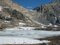
 On Fri, 5/31, I packed up my frosted-over tent and headed up toward Mather Pass. Again the trail ascends on way on the right (east) side, makes several switch-backs to gain elevation, and then traverses left through a small snow field to the Pass, reached at 9:30 am. In the snow season there is usually a cornice along the ridge. The north side had large snow fields which covered most of the trail. But with smart phones or a GPS it is no problem to retrace the trail. Simpler is to follow footprints in the snow, hoping the others were not lost. In the morning the snow was firm until the upper Palisades Lakes.
 The descent along the Palisade Creek to the Kings River was very scenic. One can see the impressive Devils Crags and other peaks of the rugged Black Divide, while at the same time the trail is surrounded by green aspen, pretty flowers and an occasional encounter with deer.
 The Kings River is fearsome during snowmelt season, except when it flows through the meadows such as Grouse Mdw. There it is wide and calm, but deep and cold. I continued to LeConte Canyon where I camped near the Ranger station. I was not bothered by bears but by swarms of mosquitoes. Lodgepole, Maverick and Broomstick passed by but I was satisfied with my 18 mi day.
 On Sat, 6/1, I got up at 4:30 am for an early start to Muir Pass. It is best to ascend it in the morning on firm snow and to descend its north side by midday to avoid postholing. Thus I climbed out of LeConte Cyn, passed green McLure Mdws, and then ascended on snow to reach Muir Hut/Pass before noon. There I met Broomstick with his four-legged companion and other hikers. There was no time for relaxing since miles of snow had to be crossed through Evolution Valley. The upper snow fields were firm but near Saphire Lake we got a taste for postholing. The snow petered out near the lower Evolution Lke where I took a long lunch break in the beautiful mountain scenery. Then it was clear cruising down to McLure Meadow where I set up camp after a 17 mi day with a high Pass.
the San Joaquin River which was crossed on a solid steel bridge.
On Sat, 6/1, I got up at 4:30 am for an early start to Muir Pass. It is best to ascend it in the morning on firm snow and to descend its north side by midday to avoid postholing. Thus I climbed out of LeConte Cyn, passed green McLure Mdws, and then ascended on snow to reach Muir Hut/Pass before noon. There I met Broomstick with his four-legged companion and other hikers. There was no time for relaxing since miles of snow had to be crossed through Evolution Valley. The upper snow fields were firm but near Saphire Lake we got a taste for postholing. The snow petered out near the lower Evolution Lke where I took a long lunch break in the beautiful mountain scenery. Then it was clear cruising down to McLure Meadow where I set up camp after a 17 mi day with a high Pass.
the San Joaquin River which was crossed on a solid steel bridge.
 On Sun, 6/2, my hike started with the supposedly tricky fording of the strong Evolution Creek. Since I hiked solo I chose the alternate route where the stream in a meadow was wide but calm and no problem to cross. I descended down to the San Joaquin River which was a wild river and dangerous to ford. Luckily, there was a solid steel bridge which solved the problem.
In the afternoon I passed near the Muir Ranch (Florence Lake), continued to ascend the PCT to the pretty Salley Keyes Lakes, then ascended the minor Selden Pass, but encountered some postholing snow on its north side. I stayed with several thru-hikers at a fine campsite overlooking Marie Lake. Maverick went fishing and caught several large rainbows, enough for everyone to enhance the usual freeze-dried dinners. At sunset Seven Gables east of Marie Lake assumed a gorgeous red colour.
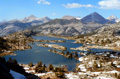
 On Mon, 6/3, I hiked down along Bear Creek, forded it at the trail crossing where the water went thigh high. Climbing up the switch-backs of the Bear Ridge the thought was about a fun boat ride across the lake to the Vermillion Valley Resort (VVR). But then we found a note that the afternoon ferry had been canceled and we had to descend an alternate route and cross the Edison Lake dam to reach VVR. By late afternoon we arrived under threatening thunderstorm clouds. Many PCT hikers were there and enjoyed a zero day. I got my resupply parcel, showered, washed clothes, ate a fine dinner and we all sat around a campfire when it got dark. Someone played the guitar and talking continued till late into the night. The next day, Tue, 6/4,, was my rest day.
 On Wed, 6/5, after a good pancake breakfast we got a boat ride across Edison Lake. Since the water level was very low it had to be a small boat which made several trips. From the boat landing I hiked to the PCT/JMT which ascended along Mono Creek to the Silver Divide. Dark clouds developed but there was only some rain but no lightning when I crossed the exposed Silver Pass around 3 pm. I saw the nearby peaks (Graveyard,
Pk 11,424,
Pk 12,221) familiar from climbs many years ago. I descended past the Indian Lakes, the Cascade Valley Trail, Tully Hole and then reclimbed in many switch-backs to Lake Virginia where I made camp with Lodgepole and Maverick as neighbors. Maverick caught another five big trout.
On Wed, 6/5, after a good pancake breakfast we got a boat ride across Edison Lake. Since the water level was very low it had to be a small boat which made several trips. From the boat landing I hiked to the PCT/JMT which ascended along Mono Creek to the Silver Divide. Dark clouds developed but there was only some rain but no lightning when I crossed the exposed Silver Pass around 3 pm. I saw the nearby peaks (Graveyard,
Pk 11,424,
Pk 12,221) familiar from climbs many years ago. I descended past the Indian Lakes, the Cascade Valley Trail, Tully Hole and then reclimbed in many switch-backs to Lake Virginia where I made camp with Lodgepole and Maverick as neighbors. Maverick caught another five big trout.

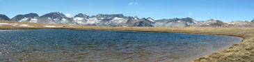
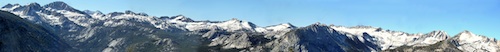
 On Thur, 6/6, the mountains around the lake glowed in red with the first sunrays. By 6:30 am I was on the way to Purple Lake, then passed nearby Duck Lake and enjoyed the scenery of the
Silver Divide from a distance. A scrolling panorama is shown below (need a 2500x1200 monitor). The trail passed near the vulcanic Red Cones before dropping into Devils Postpile Monument. While I had a double burger in the restaurant Lodgepole and Maverick dropped in too. We would often hike separately and then meet by surprise. For example, they hiked the lower trail to see the basalt columns from close-up while I took the upper PCT trail, and we met at the same time where both trails rejoined at mi 909.
On Thur, 6/6, the mountains around the lake glowed in red with the first sunrays. By 6:30 am I was on the way to Purple Lake, then passed nearby Duck Lake and enjoyed the scenery of the
Silver Divide from a distance. A scrolling panorama is shown below (need a 2500x1200 monitor). The trail passed near the vulcanic Red Cones before dropping into Devils Postpile Monument. While I had a double burger in the restaurant Lodgepole and Maverick dropped in too. We would often hike separately and then meet by surprise. For example, they hiked the lower trail to see the basalt columns from close-up while I took the upper PCT trail, and we met at the same time where both trails rejoined at mi 909.
 As I continued I also met "Billy Goat" on the bridge across the San Joaquin River. I camped at nearby Soda Springs Cpgd which had bear boxes. Nobody else camped there.
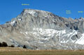
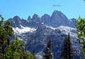
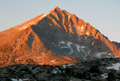
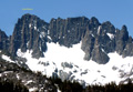
 On Fri, 6/7, I hiked the high PCT which differs from the JMT to Thousand Island Lakes. Beyond Agnew Mdws it ascends the slopes of San Joaquin and offers a wonderful view of the
Minarets,
Ritter and
Banner,
San Joaquin and the
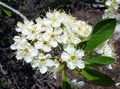
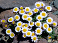
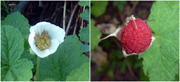
Two Teats, visited in past years. It also has many small streams which produce a garden of wildflowers. Even a brown rubber boa feasted on fresh plants near the trail. Looking back one could see the east side of Mammoth Mountain which had still a good snow coverage. The lifts were running, but probably for bikers, not skiers.
I arrived at Thousand Island Lake at 2:30 pm and guess whom I met again: Lodgepole and Maverick, who took the JMT trail. The joint trail continued via Island Lake to Rush Creek which I forded at mi 927 and where I found a nice campsite.
On Fri, 6/7, I hiked the high PCT which differs from the JMT to Thousand Island Lakes. Beyond Agnew Mdws it ascends the slopes of San Joaquin and offers a wonderful view of the
Minarets,
Ritter and
Banner,
San Joaquin and the
Two Teats, visited in past years. It also has many small streams which produce a garden of wildflowers. Even a brown rubber boa feasted on fresh plants near the trail. Looking back one could see the east side of Mammoth Mountain which had still a good snow coverage. The lifts were running, but probably for bikers, not skiers.
I arrived at Thousand Island Lake at 2:30 pm and guess whom I met again: Lodgepole and Maverick, who took the JMT trail. The joint trail continued via Island Lake to Rush Creek which I forded at mi 927 and where I found a nice campsite.
|
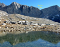
 The next day, Sat, 6/8, I hiked at 5:30 am before the sun was out. The colors at sunrise are especially beautiful and I got some nice shots of the Ritter Range reflecting in lakes. I ascended Donohue Pass where I met again Lodgepole and Maverick. There was plenty of snow on both sides of the pass which slowed down the progress. But in the early afternoon I hiked in the long Lyell Canyon. Near Tuolumne Mdws someone called "Opa": It was my daughter Isa and her husband Andrew who expected my arrival since we had planned a family meeting for the weekend.
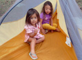
 At the campground I also met my son with his family and my second daughter Ana with husband. We all gathered at a large campsite for a fine barbeque dinner. Unfortunately, Ana got sick and had to leave. Sun, 6/9, was a rest day. After a sumptious breakfast we took my two granddaughters to a shallow part of the Tuolumne River, where we played in the water, swam, fished, ate, talked and relaxed. In the early afternoon some returned, some stayed for a second night. Isa, Andrew and I took a walk through the meadows and visited Soda Springs.
 Next morning, Mon, 6/10, I had to wait for the post office to open so as to receive my resupply parcel. By 9:30 am I hiked out along the wide Tuolumne River toward Glen Aulin. Thunderstorm clouds brewed and local rain fell in the high country. I got some short showers on my way to Virginia Canyon. There were two wet stream crossings (McCabe and Return Creeks). At mi 956 I set up camp, cooked and ate dinner as more dark clouds rolled in.
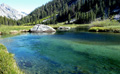
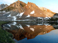
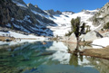
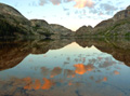 On Tue, 6/11, I hiked again early in the morning when the weather is best. I dropped into Matterhorn Creek Cyn, climbed over Benson Pass, dropped down to Smedberg Lake, ascended around Volunteer Peak, and down once more to Benson Lake. I met various hikers and a Ranger who checked me for the bear canister required in Yosemite N.P. Although there were lots of mosquitoes I decided to camp at this beautiful lake which I had all for myself. Some describe this lake as the most beautiful one of the Sierra Nevada. It certainly looked like that next morning when clouds and mountains turned red and reflected in the quiet water. The lake has a broad beach with clean reddish sand, which envites a swim, but not at 5:30 am.
 On Wed, 6/12, I hiked up to Seavey Pass, remembering the earlier peak climbs of Piute and Pettit. After the pass the trail dropped into Karrick Cyn, where one has to ford the strong Rancheria Creek and later the Kerrick Creek. , Then the roller coaster trail climbs over the Macomb Ridge and descends to Tilden Creek, another exciting ford, and continues to Wilma Lake. Although a pretty lake the mosquitoes spoiled the camping and I continued to a slightly better place at mi 989.

 On Thur, 6/13, the hike continued past Tilden Creek and impressive Chittenden Peak. One can also see Tower Peak from the PCT and vice versa. The horse tracks on the PCT turned to Tilden Lake, thank goodness. The PCT followed Falls Creek, climbed up to Dorothy Lake where I took a break to dry out my moist camping gear. Shortly thereafter I crossed the 1000 mi PCT marker which gave a feeling of satisfaction and confidence. Dorothy Pass is also the limit of Yosemite National Park, thus bear canisters are no longer required. I passed Harriet Lake, crossed the Walker River and dropped into Kennedy Canyon. I forded the rough creek in Kennedy Cyn and found a fine campsite after 18 miles with many ups and downs which is so typical for the Northern Sierras.
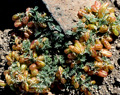
 On Fri, 6/14, I had only 11 mi left to Sonora Pass where I had scheduled another meeting with my wife and daughter who drove up from San Francisco. I climbed 1800' up from Kennedy Cyn to near Leavitt Pk. The trail ascends with wide switchbacks from dry volcanic soil into large snow fields, some of which at a significant angle but well tracked. Some of the rocks are covered with colorful lichens. The PCT crosses a ridge with impressive volcanic rock formations and then drops into the Sonora bowl well known as an excellent telemark ski terrain. In mid-June one can see amazing displays of wildflowers in the brown volcanic soil, yet some of the high altitude lakes are still partially frozen. Hiking friend "Pacman" passed me on the trail since he also had a reunion scheduled for Sonora Pass.
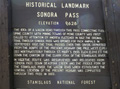 I reached Sonora Pass at 2:30 pm and hitched a ride west down to Dardanelles where my daughter Isa had reserved a cabin. In the evening we had a happy reunion, except for the news that Isa's twin sister Ana could not be with us since she was seriously ill.
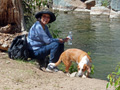 The next morning, Sat, 6/15, we took a hike along the Stanislaus River at Kennedy Mdws. It was so nice to walk without a backpack. Isa practiced bagpipes for an upcoming concert and caught the attention of many others on the trail, particularly since her dog tuned occasionally in. Since Ana was not able to be with us I decided to take a longer break to be with her in San Francisco. Next day we all drove back and visited her. She was hospitalized and weak from chemo therapy which was not yet successful. It was good to spend a week together. Then I got a ride back to Sonora Pass and continued the hike, keeping in touch by phone about any new developments.
 On Sat, 6/22, I headed up the hills north of Sonora Pass. Partially I felt good to be back on the trail, but there was a dark cloud in my thoughts. The trail ascended to Wolf Lake, dropped down to E. Carson Creek and then climbed over the Boulder Ridge. Near Golden Lake Creek I found a small campsite at the end of a 17 mi day. During the day I met at least seven PCT hikers and it was fun to talk with Bristlecone and Uberbitch and Samba and Taliva and others.
 On Sun, 6/23, I got up at 4:30 am to be on the trail an hour later. There was again a bloody red sunrise and sure enough it rained in the afternoon. The hike toward Ebbett Pass dropped 800' down to Wolf Creek, then meandered to Hwy 4 (mi 1050) where I had lunch. I passed by the Kinney Lakes to Eagle Creek (mi 1055) where I camped after a 20 mi day. In the evening there was partial rain and sunlight. But overnight a front moved in. Lateron they called it an unusually late "Alaskan Express".
On Mon, 6/24, morning it was windy, cold and raining. The mountains of the Mokolumne Wilderness looked dark and gloomy. There were several ridges to cross on the way to Blue Lake. By afternoon I ascended the exposed ridge of The Nipple and was caught in the worst storm conditions. I hiked in a whiteout, wet from rain and sleet, with the wind blowing so hard that hiking poles were needed to keep the balance. Hands, feet, arms and legs were all wet and cold in spite of several layers of clothes. It was clearly hypothermia weather and the only solution was to keep going to stay warm. Finally, the trail dropped into a forested area with campsite at the Lost Lakes. To my surprise there were at least five tents from other hikers caught by the same conditions. I set up my tent in the rain and got as fast as possible into the dry sleeping bag. Since cooking was not possible I had a cold dinner of power bars and trail mix which at least produced body heat. It stormed all night and I was so glad I had a good tent. Don't expect any pictures from this gloomy day.
On Tue, 6/25, morning it was still raining, windy and a whiteout. Most everyone decided to stay and wait out the storm. But by midday I got ancy and decide to go for it. In the afternoon the rain turned into intermittent showers. The supposedly steep snowfields of the Elephant Back posed no problems. By 4 pm I arrived at Carson Pass. The Ranger welcomed five PCT hikers to his warm and dry Visitor Center. But it closed at 4:30 pm and the hike continued in intermittent rain. The hills were full of Mule Ears and other wildflowers. A nice campsite was located after 5 miles, appropriately named Shower Lake. Tomorrow it would only be 11 mi to Echo Lake/S Lake Tahoe.
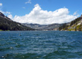
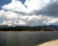
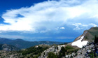
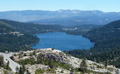
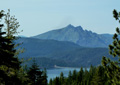
 On Wed, 6/26, it was windy but the clouds were gone. The trail had the usual ups and downs and stream crossings, but the most tricky was crossing Hwy 50 with lots of cars at 70 mph speed. The highlight was the view of distant Lake Tahoe which looked truely blue. At 11 am I reached Echo Lake, headed to the Berkely Youth Camp, but did find my resupply parcel. It was at the Echo Lake Chalet, where many PCT hikers hung out for food and packages. It was too early and too touristy to stay. Thus at 2 pm I started to hike around Echo Lake into the Desolation Wilderness.
 Lake Aloha was impressive in the sense of sheer size, rocky terrain and many islands with dead trees. At the end of Lake Aloha the trail turned east to two pretty lakes, Heather and Suzy. There are also many gnarly old cedar trees near the trail. In spite of the many mosquitoes I decided to camp at Suzy Lake after hiking 20 mi this day.
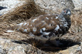
 On Thur, 6/27, I was on the trail by 6:30 am heading toward Dicks Pass (9174', mi1108). Before reaching the pass one had a nice view of Jacks and Dicks Pks above Halfmoon Lake. Early in the morning a coyote casually strolled along a side trail. I also saw a grouse with 5 chicks, none of which flew away as I stood still. Morning hour is the best to observe wildlife. By 10 am I was on Dicks Pass and found that the north side still had plenty of snow. The way down passed nearby Dicks Lake, Fontanillis Lke, Velma Lks to Richardson Lake, crossed Miller Creek and provided nice campsites at mi 1124 with water from the Bear Lake outlet. Since it got warm again I cleaned myself and some clothes. Several hikers joined the camp since it is shown on the Halfmile Map. So ended another 20 mi day.
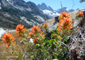
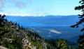
 On Fri, 6/28, I hiked by 6:15 to 8 am from camp to Barker Pass. There was another 600 ft ascent to a ridge with fine views of Lake Tahoe. To the west one could even see the mountain range beyond the San Joaquin Valley. The joint PCT and Tahoe Rim Trail (TRT) had a few ups and downs near the Twin Peaks and The Five Lakes but was otherwise a very scenic crest trail, particularly in the Granite Chief Wilderness. There were great views of Lake Tahoe. Wildflowers were abundant. I even had a chance to drink clear cold water from the spring of the American River (mi 1142). In the afternoon thunderstorms rolled over Lake Tahoe. I camped just below Granite Chief with lifts down to Squaw Valley. Although I never skied at Squaw Valley I climbed Granite Chief and Tinker Knob since they are on the SPS List and had a nice remembrance of it. Lateron Split and Doublestep also joined the campsite. This 19 mi day was one of the most scenic and enjoyable ones and I took many pictures.
 On Sat, 6/29, the trail passed close to Tinker Knob whose slopes were filled with wildflowers. The ridge trail continued to Anderson Peak, Lincoln and Judah where I once skied with my son via Sugar Bowl. Then the PCT drops down to Donner Pass where all food services on Hwy 40 were closed to the disappointment of the many visitors including me since I was getting short in food till Sierra City. Thus, I continued the PCT to its crossing with Interstate 80, the main highway between CA and NV. There were tunnel under both highway lanes going in opposite directions.
 Right beyond the intersection is a Highway Rest Area where I refilled water. Unfortunately, all vending machines were closed. But I got into a conversation with travellers who later gave me some refreshments. There are trail angels everywhere. I continued to hike to the Peter Grubb Hut, a Sierra Club ski hut near Castle Peak. Unfortunately it was closed and we had to camp in its backyard.
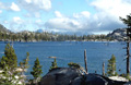
On Sun, 6/30, I hiked out at 6 am over Basin Pk Pass down to Paradise Valley, then over a ridge to Bear Valley, up over the next ridge to Meadow Lke Road, then continued to climb another ridge. There were no water sources for 13 miles but one had the first views of the Sierra Buttes. The trail dropped down to the large Jackson Mdw Reservoir and I camped in a State Park campground near the water. PCT hikers are treated nicely and I paid nothing for the campsite with bench, and a neighbor gave me more food than I needed till Sierra City. I also took a swim in the lake and chatted with neighbors till it got dark at 9:30 pm.
 On Mon, 7/1, I started at 6 am for a short 13 mi hike to Sierra City. I followed the PCT rather than the shortcut and hiked 1.5 mi on Hwy 49 to the Red Moose Inn in Sierra City. It was a perfect hikers home operated professionally by the hosts Bill and Margaret. Probably a dozen hikers were present. I reunited with George whom I had not seen since we hiked together in SoCal. I received my resupply parcel, showered, washed clothes, got a free beer, shopped in the Country Store and had a spare rib dinner with more beer and ice cream for desert. There was also a cherry tree in the garden and I was allowed to eat them since the only other customers were the birds. Many of us slept under the stars.
This may be a good location to take a break with this trip report. The trip from Sierra City to Oregon is continued in "Part 3: Northern California".
Go back to Part 1
Go on to Part 3
Go on to Part 4
Go on to Part 5
Back to Trip Reports
Back to SMS Home Page
|
