
![]() When Randy and I first planned this trip, we figured that Onion Valley Road would be open all the way to Onion Valley. It was always opened before, even in some of the wetter years by the 1st of April. Maybe the County figured that opening up a road was not worth it for the few backcountry skiers that venture up this time of year. After we heard that the road up to Glacier Lodge road was open to the lodge, we changed the plans for Saturday to Big Pine Creek. The night before the group arrived at the campground west of Big Pine.
When Randy and I first planned this trip, we figured that Onion Valley Road would be open all the way to Onion Valley. It was always opened before, even in some of the wetter years by the 1st of April. Maybe the County figured that opening up a road was not worth it for the few backcountry skiers that venture up this time of year. After we heard that the road up to Glacier Lodge road was open to the lodge, we changed the plans for Saturday to Big Pine Creek. The night before the group arrived at the campground west of Big Pine.
It was a big group indeed with Randy Lamm, Mike Rector, Bahram Manahedgi, Paul Gerry, John Anderson, Jim Garvey, Reed Moore, Micky Bozyola, Alysa Vos, Ken Deemer, Jim Derose, Kat Seiple and I. We met Alvin at the trailhead with his group of harder core skiers attempting Mt. Kid. After a slow start, we start out on the North Fork trail of Big Pine Creek. Reed led most of the way into Big Pine Creek basin with a trail walk for the first 2-3 miles along south facing slopes. The snow was fairly hard and intermittent, so it wasnât too hard to walk with the skis on the back. Not that an extra 6 pounds on your back makes a big difference. More for the folks that carried ski boots while walking in sneakers. After getting to First Lake we finally were able to put the skis on for continuous snow. The lower route had better coverage with more North facing slopes and a lower profile to the sun. The route followed the lower trail just above 2nd and 3rd lakes. The optimistic objective of the day was Sam Mack Meadow. Given all the distance from the cars, it took a fair amount of time to get to the approach to Sam Mack. Reed attempted the route up, but found the snow a bit sugary and sticky.
 We all took a break right below the approach enjoying the warm sun and calm winds. More weather for a summer backpack than a spring ski. Ken, Micky and Alysa did a climb up the steep north facing ridge of
Sam Mack finding good conditions. The rest of us started the decent back with the idea of staying in the drainage. The lakes were well frozen over for a fast traverse. We were greeted with a variety of obstacles at the exit points of each of the lakes. At Third lake, we did the limbo under a walk way (old mining railway bridge). By the time we got to Second Lake, we had to veer to the left of the dam at the confluence. We had to search for the best route to the North side of the canyon for the best coverage. Bahram had the right idea of descending before the cliff ridden drainage. The snow was icy in spots from the shade of the trees on this North Facing slope.
We all took a break right below the approach enjoying the warm sun and calm winds. More weather for a summer backpack than a spring ski. Ken, Micky and Alysa did a climb up the steep north facing ridge of
Sam Mack finding good conditions. The rest of us started the decent back with the idea of staying in the drainage. The lakes were well frozen over for a fast traverse. We were greeted with a variety of obstacles at the exit points of each of the lakes. At Third lake, we did the limbo under a walk way (old mining railway bridge). By the time we got to Second Lake, we had to veer to the left of the dam at the confluence. We had to search for the best route to the North side of the canyon for the best coverage. Bahram had the right idea of descending before the cliff ridden drainage. The snow was icy in spots from the shade of the trees on this North Facing slope.
 After getting to the bottom of the drainage again, we did indeed; follow the North side of Big Pine Creek. It took a number of stream crossings to stay in the snow. It was soft and manageable, for the most part. After a couple steep traverses and more creek crossing, we finally hit the snow line. For some this extended to the large waterfall (ambient a few dry patches walking on skis). By the time we got to the cars it was 6:30PM. A long day for a day ski. After a quick drive down to the Owens Valley, Mike, Kat, Randy and Ken and I met up at one of the Keough Mud holes for a pleasant soak and beer. The water was not hot, but with balmy air, it was just what the doctor ordered. Needless to say, it was a late dinner by the time we got back to the campground. The next day dawned as clear and warm as the day before. Randy and Ken had driven up the Onion Valley road on Friday to within a mile of the Onion Valley trail head. The important point is one mile as the "crow fly's".
![]() Much further than the spot the ranger had mentioned. Mike explained to me the nuances of road closure postings between various agencies. In this case, it meant we don't maintain the road past the stated closure, but if you want to proceed, go for it! Rocks littered the road on the way to the closure point, but the folks before had cleared enough of a path to get a vehicle through. After getting to the snow, we realized the snow on the road was no going to let us proceed and that one crow mile did not sound that appealing (unless we could sprout some wings).
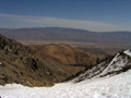
Especially given the elevation gain on the road of some 1,300 feet. Lucky for us, Bahram knew that Sardine Canyon would have snow. So we drove back down the rocky strewn road to the big switch back at 7,500' where the dirt road goes north along about a mile to the bottom of Sardine Canyon. I remember this from a trip with Reiner to Little Onion Valley several years ago. The slopes along the dirt road approach were blackened and scorched from a recent fire. So much so that the ski boots collected a far amount of moon dust. Feeling like astronauts with the tiny town of Independence in the distance we proceed to the narrow notch of Sardine Canyon.
Much further than the spot the ranger had mentioned. Mike explained to me the nuances of road closure postings between various agencies. In this case, it meant we don't maintain the road past the stated closure, but if you want to proceed, go for it! Rocks littered the road on the way to the closure point, but the folks before had cleared enough of a path to get a vehicle through. After getting to the snow, we realized the snow on the road was no going to let us proceed and that one crow mile did not sound that appealing (unless we could sprout some wings).
Especially given the elevation gain on the road of some 1,300 feet. Lucky for us, Bahram knew that Sardine Canyon would have snow. So we drove back down the rocky strewn road to the big switch back at 7,500' where the dirt road goes north along about a mile to the bottom of Sardine Canyon. I remember this from a trip with Reiner to Little Onion Valley several years ago. The slopes along the dirt road approach were blackened and scorched from a recent fire. So much so that the ski boots collected a far amount of moon dust. Feeling like astronauts with the tiny town of Independence in the distance we proceed to the narrow notch of Sardine Canyon.
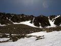
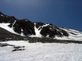
 The snow had deep sun cups and was littered with a lot of avalanche debris and dirt for the first mile through the narrow canyon. The higher we ascended, the more the canyon opened up. When we started up around 9am it was warm at the bottom of the canyon. Skining up it was more like traversing thru the Kumbu glacier stepping over 6" suncups. As we proceeded up into the middle of the canyon the snow smoothed out. After about 700' of vertical we noticed a path on the north side of the canyon (south facing) which was dry and appeared to be an old mining road. This would have been an easy walk up if we had noticed it earlier. Probably would have had access if we had walked just north of the bottom of Sardine. We continued up. Around noon the wind picked up and cooled things down. The snow which was starting out soft and had potential of corning up instead was during hard and almost icy. The soft sun cups were turning had and our skins were not gripping so well.
Another group of skiers from Bishop were ahead of us and they appeared to have made it to the top of the canyon. Most of us topped out at a broad bench at about 10k. The snow on the climbers right side of the canyon was softer while on the left it was icy. We could see the Bishop skiers coming down making long turns. Above and to the left were the North slopes of Kersarge Peak. There were obvious Couloirs coming down from the summit into Sardine. These would be the slopes where it would be possible to link up a car drop off at the dirt road switch back, take another car and car pool up to the OV parking area and climb the south east ridge of Kersarge Pk to the summit. Then drop one of the north west couloirs down to Sardine for a 7k vert run. At this point it would not have been too good as the snow was blown or melted off the top of Kersarge pk exposing the talus and boulders about a 1/3rd of the way down. As the wind picked up the group pulled skins and headed down . About 700' from the bottom the sun cups were too gnarly to continue skiing and most put skis on pack and walked down to the snow line and out on the dirt road. We got back to the cars around 2:30 and headed down into the warm Owens Valley and back to life's routines in LA.
Back to Trip Reports
Back to SMS Home Page