
 Summer trips into the Sierra Nevada are a wonderful contrast to our ski mountaineering trips. You can go light, the weather is warm and stable, water is abundant and the mountains are full of flowers. I like to explore new areas in the heart of the Sierras. The Muro Blanco is one of those, as once suggested by Steve Hessen. It is the north face of Arrow Peak in Kings Canyon NP but also refers to the canyon of the South Fork of the Kings River between the John Muir Trail and Paradise Valley. R.J. Secor describes it as one of the classic bushwhacks of the Sierra Nevada. Thus no trails, no people, and some gorgious terrain along a wild river. For a change this is not a peak climbing report, but then the Sierras can be enjoyed in many other ways.
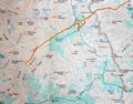
 The shortest access to the Muro Blanco is via the Taboose Pass trail. It's a tough hike. The trail starts at valley floor and climbs 6000' up to Taboose Pass at 11,350'. It crosses the Taboose Creek twice, otherwise water is scarce. In mid-summer it was 99 deg at the trailhead. Thus I started my hike on Wed at 6am just before sunrise to beat the heat.
 Sunrise produced beautiful sceneries in the canyon. The northwest ridge from Goodale Mountain lit up bright-red. The first mile of the trail is in soft sand and a desert-like environment. The first creek crossing required some attention since one had to step on submerged rocks. Some shady sections on the trail are very pretty and so is the scenery of the steep mountain walls on either side of the canyon. The climb goes from one plateau to the next one separated by sections with many switchbacks. Much of the trail is covered with mid-size talus which is actually more trouble when descending than on the ascent.
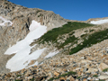
 Since we had an above-average snow season in 2009-10 there was still plenty of snow near the top of Taboose Pass. One snow field had a wall of at least 12 feet height. I could see the slopes which we had ascended on skis in 2002 on the
Cirque Crest Traverse and skied down on the Sierra Crest Tour in 2004. It was my fifth time over this Pass.
Since we had an above-average snow season in 2009-10 there was still plenty of snow near the top of Taboose Pass. One snow field had a wall of at least 12 feet height. I could see the slopes which we had ascended on skis in 2002 on the
Cirque Crest Traverse and skied down on the Sierra Crest Tour in 2004. It was my fifth time over this Pass.
By lunchtime I reached the Pass. As usual it was windy and cool in this open terrain. Thus I descended until there were some trees and found a nice stop for a long lunch break. At 2pm I continued down the Taboose Pass Trail to the John Muir Trail. At the peak of the hiking season one meets many people on the JMT. After crossing the South Fork of the Kings River which starts in the Upper Basin, I descended on the Cartridge Pass Trail on the north side of the Kings River. This unmaintained use trail is initially quite easy to follow since horses and hikers travel over Cartridge Pass into Lake Basin.
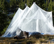 Initially the trail goes high above and parallel to the Kings River mainly through forest. Then talus slopes come down the slopes from Mt Ruskin forcing the trail toward the River. There were some pretty meadows. Below Bench Lake I found a nice campsite near the Kings River. The first job was to set up my mosquito net since the critters were out in force. I had left my tent behind since good weather was forecast. It was time to relax after the long day. I rehydrated, had a good dinner and went to bed as the sunlight disappeared. At night the temperature dropped and in the morning frost covered the sleeping bag.
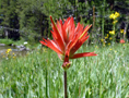
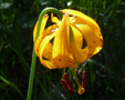
 Thursday, 8/5, was the day for exploring the Muro Blanco. By 7am I left camp with a light pack and headed down the Kings River. Occasionally, the trail became faint and crossed over talus slopes and through willow and aspen brush. Below the creek from Cartridge Pass it was essentially cross-country travel. The terrain was alternating between forest, brush and open meadows. The latter were covered with beautiful wildflowers. I enjoyed the scenery very much and took many pictures.
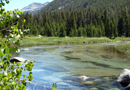
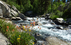
 The Kings River is also spectacular. It varies greatly with wild cascading sections, waterfalls, deep green pools, gushes over rock slabs and quiet meandering sections through green meadows. Crossing the river is only possible at very few places. Swimming in pools is risky and the water is cold. But a refreshing dip in the midday sun is a delight. On many occasions I saw trout in the water, but fishing was not on my agenda.
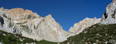
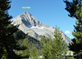
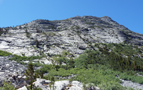
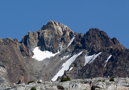
Soon the Blanco Muro became clearly visible. It is a smooth rock wall on the northwest face of Arrow Peak. It appeared to me more gray than white. It may not be as spectacular as some glaciated walls in Yosemite, but the real attraction is the beauty of the canyon with its surroundings. Several streams with waterfalls are coming down from the Cirque Crest.
 Somewhere below State Peak the canyon narrowed and the brush thickened. It would now be several miles of bushwhacking to Paradise Valley if one intended a traverse to Cedar Grove. This would also require a shuttle and several more days which was not the purpose of this exploratory trip. Thus, on some fine rock slabs at the river I had a snack, a refreshing dip and then decided to hike back up.
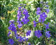
I arrived at camp in the early afternoon, packed and continued upstream. By 4pm I was at the JMT to again cross the Kings River and to ascend the forrested slopes toward Taboose. Above the forest there were meadows filled with blue lupins and larkspur.
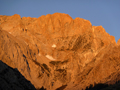
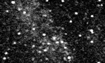
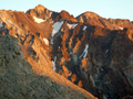 Several prominent peaks were visible, such as Cardinal, Goodale, Striped, Pinchot and Ruskin. By 6pm I found a nice campsite a mile below windy Taboose Pass among trees and a nearby stream. The sunset time produced gorgeous colors on the peaks and in the sky. At high altitude (>11,000') on a cloudless day the night sky without moonlight produced a spectacular display of stars. Venus was bright and beautiful. The Perseid meteor showers were starting and about every minute a shooting star was visible. I could clearly see my Subaru (=Pleiades). No mosquito net was needed since it got cold at night. In the morning I found frost on the grass and ice on water puddles. The quiet night was once interrupted by a thunderous rockfall.
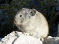 Friday, 8/6, was the last day of my short trip. I climbed up to Taboose Pass where I was greeted by warm sun. Actually, I was greeted by a little pika in the rocks. He or she was not shy and posed for a picture. Later I met other hikers heading both up and down the trail. Going down requires some attention since the trail is filled with loose rocks ideal for spraining an ankle.
With each hour the temperature rose. Once out of the canyon there is still has a mile of sandy desert hike. By 11 am I was back at the car, an hour later had lunch and a clean up at Keough, and then cruised back south at a moderate temperature of 95 deg in Mojave. In retrospect this short exploratory trip was into a new and pretty area of the Sierras. I also like to experience the contrast to our ski trips. When everything is covered by snow you miss all the flowers and warmth, but you need no deet and descend easily over all the Taboose talus and brush. Each season has its fun.
Back to Trip Reports
Back to SMS Home Page