
|
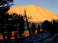
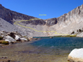
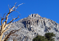
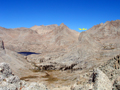
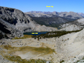
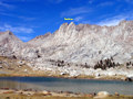
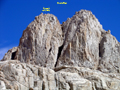
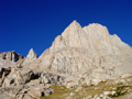
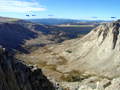
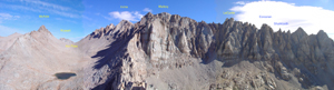
I had scheduled this trip for the last two years (see Archives) but it never materialized. Since the peaks are not on the SPS List, few peak baggers are interested in climbing them. But especially The Miter is a real climbing gem. A short trip report was found on climber.org, but none in the SPS archives. The peaks are located in the southern Whitney group, more precisely south of McAide in Miter Basin or the Rock Creek drainage (not Little Lakes Valley). It takes a day to get in and out, so I made it a 4-day trip. On Tue, Sep 11, I drove from L.A. to Lone Pine, got a wilderness permit and hiked in to the Cottonwood Lakes, camping at the long Lake #4. It was warm, a moonless night with a spectacular star display at 11,000'. No bears, no mosquitoes, few people. On Wed, Sep 12, the summer seemed to come to an end with high winds preceeding a cold front. I climbed over old Army Pass (11,972') to be nearly blown over. My destination was Sky-Blue Lake in upper Miter Basin. Since it is not far, I decided to climb The Major General on the way. The Major General is a named peak which must have been a mistake by the USGS. Although it looks like a nice summit from Miter Basin it really is only a high point (12,316') on a long ridge coming down from Mt Langley. It is often climbed on the way back from Langley. From other directions one has to endure an ascent over loose scree slopes, no fun with a full pack, as I can attest. Coming from Army Pass I went north on the trail to the Soldier Lakes, then ascended XC the west ridge from Langley and soon reached the cl3 summit block of The Major General. There was a 20-year old peak register. I found only two names of familiar SPS members (Secor, Oliver). R.J. describes the peak as not worthy the climb, but the views were nice: The Soldier Lakes are pretty, the view up Miter Basin is splendid with the scenery of familiar peaks, such as Pickering and Joe Devel, which we once skied. It was nice to see in a different season peaks like The Miter, McAdie and the Irvine-Corcoran Ridge. I descended from this minor peak climb into Miter Basin and headed up Rock Creek. This is a pretty valley with open meadows, some lakes and stands of foxtail pines. Ten years ago we skied along this valley on a traverse of Mt Whitney. I took a break at a small unnamed lake south of The Miter but it was too windy and cool for a swim. In the late afternoon I headed up to Sky-Blue Lake where I set up camp. From the summit of The Major General, The Miter looks like a rather small peak, maybe like Fin Dome near the Rae Lakes. But that changes as you approach it. Near Sky-Blue Lake The Miter is an impressive peak with two summits and steep walls for technical climbers. Yet there is a nice class 3 route on the north side. From the north the peak actually resembles a mitre hat. It was a cold and windy night at Sky-Blue Lake (11,552'). Cirrus clouds indicated an incoming front. But next morning it was still clear. On Thur, Sep 13, I got up at 6:30am and started to hike an hour later. One ascends an obvious chute from the lake to a plateau at the base of the mountain. Then one climbs on loose scree to the north side of the North peak. |
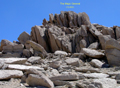
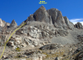
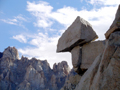
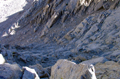
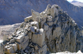
There you see a rock outcropping with a huge chockstone. Pass in front (west) of this "bridge rock" and you enter the north chute of The Miter. It is a wide chute which ends in a steep wall below the summit ridge. There are two landmarks visible: A large block on the left summit ridge which seems to fall down any moment. This teeter-totter boulder is to the left of the summit area. On the right side of the ridge there are also huge rocks which provide a keyhole to ascend the ridge. Anything else is class 4. One ascends on various ledges traversing between the middle and the right side of the chute. It is fun class 3 climbing. It was cold and windy in the north facing chute. I would not attempt it when covered with snow.
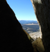
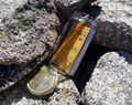
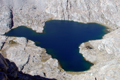
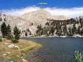
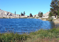
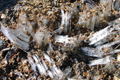
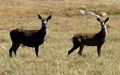
The keyhole is a narrow north-south passage between vertical blocks on the right summit ridge. The wind funneled through the hole like in a wind tunnel. After some failed attempts I got through between the gusts. On the south side of the ridge the fun continued, but luckily with warm sunshine and less wind. It required some route finding skills and high class 3 moves to reach the summit block. It was 8:45am when I reached the summit (12,797'). A very recent Miter trip report mentioned the disappointment of finding no summit register. Thus, I brought one along and placed it in a cairn on the summit. I enjoyed the summit views of many familiar peaks, passes and lakes. Particularly impressive was green-blue Iridescent Lake in the morning sun. The jagged ridge line from Irvine, Mallory, LeConte and Corcoran was also amazing. To the south one could see across the Southern Sierras and the foggy San Joaquin Valley to the San Rafael Mountains, at least a 100 mi visibility. After a snack and lots of picture taking it was time to descend. I had left a few cairns on my way up which were helpful for retracing the route. On the other hand, there is not one but many ways to traverse on the ledges in the north chute. It was a fun climb and by 10:30am I was back at camp. By 11:00 I left pretty Sky-Blue Lake while another group was heading up. My destination was to camp at the Soldier Lakes. The lower one is usually very popular, but when I arrived I had it to myself and stayed, especially since it was wind sheltered in a valley with trees. Part of the lake was turning into a meadow in this low-rain year. Ducks were swimming along the marshy shore and trout were jumping at sunset. Too bad I had no fishing gear for the big goldens in the lake. On Fri, 9/14, I climbed to the upper Soldier Lake which has some pretty stands of foxtail pines, then continued up the trail to Army Pass. On the way I saw an interesting formation of needle ice produced by subfreezing temperatures at night. On the open plateau above the pass the wind was howling again. Army Pass is straightforward in summer but in the snow season the descent may be a challenge. I followed the trail along the Cottonwood Lakes and saw some pretty deer in the meadows. Lateron some guys in camouflage and red hats came up. Nature's cycle continues. In the evening I drove to Onion Valley to join Randall Danta's SPS List finish climb of Independence Pk on Sat, but that's another story. |
Trip pictures (click for large version):
|
|
|
|
|
|
|
|
|
|
|
|
|
|
|
|
|
|

|
|
|
|
|
|
Back to Trip Reports Back to SMS Home Page |