
|
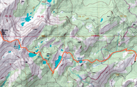
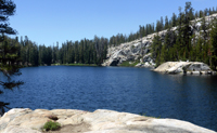
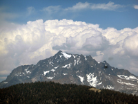
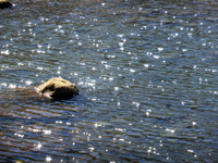
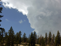
Summer has just started. Coved-19 is not over. One has the urge of getting out and enjoy the nature. Thus I started with a short trip to the Sierra Forest Wilderness. No need for any stress to finish peaks anymore, but Madera is a left over in my mind. It is at the southern end of a ridge from the Clark Range, Merced Peak, Sing, Gale and lastly Madera. Nothing challenging, but a nice hike along the pretty Jackass Lakes, which do deserve a better name. On Mon, 6/22, I left the Bay Area, drove to North Fork where a permit was waiting for me at the Ranger Station, then drove up the looong winding Minarets Road ending at the unpaved and potholed Beasore Road from which the same to Norris Trailhead. That was enough for the day. On Tue, 6/23, I had an early start to the three Jackass Lakes.The trail is well marked, but climbing steadily. One first reaches Norris Lake, which is surrounded by trees. The trail continues to climb and leads to the first and largest Jackass Lake. In spite of its name it is a beautiful lake. When I arrived there was nobody there other than lots of mosquitoes. The trail continues to a small and round middle Jackass Lake. In forested areas the trail has quite a few fallen trees. In open areas the trail can be easily lost but cairns mark the right direction. By mid day I reached the third Jackass Lake, the prettiest in my opinion. There are good campsites, nice beach areas, and a view of my next destination, Madera Peak. Again I had the lake for myself and enjoyed a dip into the cold water. I took pictures and watched the billowing clouds to the north, Yosemite Park. In the late afternoon other hikers arrived at this pretty place. Wed, 6/24 was my climbing day. It is an old rule to have an early start since clouds build up during the day. From Lake 3 I ascended XC to the small Burro Lake. It is a typical high elevation lake which is fed by melting snow patches. The water is cold and clear, has no fish and fewer mosquitoes. The next route is in the NW direction to a small saddle in the ridge. Lots of talus, no cairns, do it yourself. Reaching the ridge one finds another ridge in the direction of the peak. This ridge has yellow-reddish rocks. The end of this ridge looks like the peak, but from there one can see the real peak. There is also a small group of trees which is visible from the lake. |
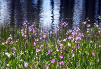
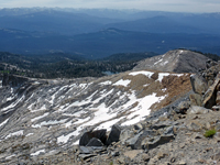
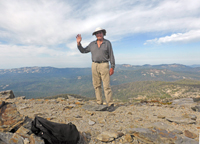
The last ridge is a mix of boulder hopping and patches of sandy trails. Within 30 min one is on the top. There is no summit block, just a flat plateau with a cairn. But the good news is that you can see for miles and miles in all directions and see endless numbers of mountains. In summer time the air is a bit hazy.
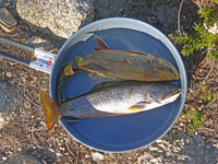
Another surprise is that there is an ammo box with a fine register book with many signatures. It started from 2016 and 2/3 is filled. Most visitors are from local and the Bay Area but fewer from Southern Cal. I found no signatures from SPS or SMS members. The peak is not on the List and skiers cannot reach it since the long roads are closed in winter. There is no cell phone connection on the summit. After relaxing, snacking and picture taking I descended again at about the same route. On talus blocks one has to be careful due to moveable rocks. Finally, back at camp I relaxed and tried some fishing. Too early, the fish were in the bottom and middle of the lake. They show up only at sunset and sunrise time. I was tired and decided to fish early on Thur, 6/25. After trying power bait, flies and artificial lures I had luck with the last. My first catch was a big trout which I lost when shoring. Next time I kept the fish under tension and let him travel back and forth to release its energy. I was content with two big rainbows which I fried in a pan which was a hearty breakfast. I leisurely packed up and headed back. The day got warm and clouds were growing. I recall from earlier trips that this can lead to afternoon surprises. Thus I decided to head back to the trailhead since I had reached what I wanted. The return was straightforward. I met other hikers on the trail climbing up. Among them was a group of 6 youngsters in National Park uniforms. An more mature woman explained that she is training young people as rangers. They had a 6 foot long manual wood saw to cut thick trees fallen over the trail. The training also included that the rangers wanted to see the wilderness permit, bear canister, name and permit office, all written by an apprentice. He was not allowed to touch my permit--a reminder that it is still covid-19 time. I thanked them for the trail maintenance and we parted in a good spirits. I arrived at the car in the early afternoon when a dark cloud began to cover half the sky and thunder could be heard. It was perfect timing and a perfect trip. I drove home on the infamous Beasore Road and arrived home at 8pm. |
Trip pictures (click for large version):
|
|
|
|
|
|
|
|
|
|
|