
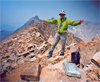
 This was a summer trip by two SMS members, Leslie Hofherr and myself. Maybe the report will stimulate more peak climbing among skiers during the season when there is no snow. It was a week-long trip into the Kaweah Basin to climb some remote peaks, which were the next-to-last ones for my SPS List finish. We also explored a rarely climbed route on the east side of Mt Kaweah. It was also nice to see an area in the summer which I remembered from winter when skiing the Sierra High Route near the Kings-Kern Divide.
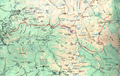
 Briefly, our tour started at Crescent Meadow in Sequoia N.P., followed the High Sierra Trail to the Big Arroyo, Chagoopa Plateau, went XC via Kaweah Pass into the Kaweah Basin where we established basecamp. We climbed Kern Point as a day trip and Picket Guard as a second day trip.

 On the way out we climbed the east face of Mt Kaweah which will be mainly described. Then we retraced our route. But just to mention that Picket Guard was a fun class 3 climb rewarded by a 40-year old register, while Kern Point was an uninteresting scree scramble.

 Mount Kaweah is a frequently climbed SPS emblem peak. The standard route is an easy, but boring and energy-draining 3000' talus climb on the south face from the High Sierra Trail. The present report describes a shorter, more interesting class 3 climb up the steep northeast face from Kaweah Basin, as briefly mentioned by R.J. Secor. To our knowledge the route is not described in the SPS/PCS trip archives and rarely mentioned in the summit register.
![]()
 It starts at Kaweah Pass (0.4 mi NE of Mt Kaweah, UTM 11 3 68 047E, 40 43 762N, elev 12,397'), involves a 1400' cl 3 climb to the northeast ridge and tops out just below the summit. Route finding and loose rock are the main challenges, but the peak can be climbed in 2 hrs. It is a fun climb when one crosses Kaweah Pass, as we did on this private trip. I did my last orphan peaks (Kern Pt and Picket Guard, #246) and Leslie Hofherr wanted to add another emblem peak. Here is the route description:
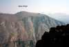
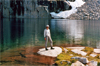
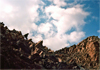
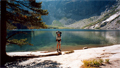
 Just below Kaweah Pass there is a large unnamed lake at 12,320' or 3770m. Looking from the lake to the NE face of Mt Kaweah one can see several chutes ending in talus fans. We started with the most obvious one whose talus fan aims at the middle of the lake. Wrong chute! It leads into a snow/ice field and cl 4-5 headwall. After a humiliating retreat we tried the next chute south. It has a small talus field which points exactly to the south end of the lake, as mentioned by Secor.
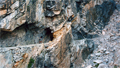
The chute is not very pronounced but it is the correct one. Ignore the next big chute 300' south of the lake. For perfectionists, start at UTM 11 3 68 107E, 40 43 363N, elev 12,505', and aim for the highest point on the ridge which is close to, but not the summit. The chute leads soon to a steep cl 3 section, and then mellows out into easy looking terrain.
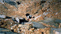
 But in the Kaweahs virtually every rock is loose. On steep sections one can easily trigger a rockslide from above. We were either "simul-climbing" (in parallel) or took turns in climbing/hiding. We avoided passing close to and below big boulders since they could be destabilized and roll down. It was a great exercise in cat-like climbing. When our chute turned south and away from the summit area we climbed onto a ridge to the right and proceeded until we could enter a new chute to the right. This chute is a continuation of the chute starting at the middle of the lake but has the cl 4-5 section further below. We ascended this chute that steepens to high cl 3 and tops out on the northeast ridge of Mt Kaweah.
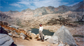
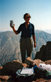
 Suddenly, we were in flat terrain. The summit of Mt Kaweah (UTM 11 3 67 720E, 40 43 130N) was about 300' northwest of us and an easy stroll up. After 2 hrs of concentrated climbing on loose rock we had a relaxing time on the summit, reading the three register books, taking pictures and enjoying lunch on a perfect summer day. Unfortunately, the views from our 13,802' vantage point were obstructed by smoke from a large forest fire near the southern Kern River. We admired the impressive peaks of the Kaweah Ridge to the north but could not see Mt Whitney to the east. After an hour on the summit we descended. Experience from earlier climbs in similar terrain taught me to carefully mark the ascent route with numerous cairns, in particular the entrance to the correct chute. We followed our ducked route since a wrong chute can easily lead into cl 4 terrain. Down climbing may be physically easier but the loose rock in cl 3 terrain calls for full attention.
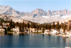
 The descent took as long as the ascent, about 2 hrs. Looking back at the bottom we were delighted to have climbed this short but challenging route safely without a scratch. From Kaweah Pass we descended to our base camp at the small "Pika" Lake at the start of Chagoopa Creek (UTM 11 3 69 327E, 40 42 984N, elev 11,767'). There are no campsites at the upper summit lake or Kaweah Pass where the terrain is a landscape of rugged boulders. By the way, Kaweah Pass is described as a cl 2 pass leaving the impression of an easy traverse. However, with full pack the descent into Kaweah Basin requires extreme caution since most rocks are loose, just like on Mt Kaweah. From the pass aim well to the right of the first lake (0.5 mi north of the Pass) so as to avoid the steep cliffs that are not visible from the Pass.
In retrospect, the described route is fun for a small group of experienced climbers. It may not be advisable for big groups or in incremental weather due to random rock falls whose impact marks is everywhere visible.
Back to Trip Reports
Back to SMS Home Page