
 It has become a tradition for the SMS to have at least one long summer Sierra trip. Leader Tom Marsh gracefully organized some challenging routes such as portions of the Roper High Route or XC Sierra traverses. This year he planned a circumnavigation of Mt Ritter and the Minarets, another great adventure. But two problems arose, one personal timing conflict for me and another caused by Mother Nature. The former was my long-planned 50'th anniversary trip to Alaska which conflicted with the Sierra trip. The other was the unusually large snow coverage this year which required snow travel at high altitude with associated equipment.
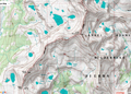
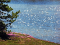
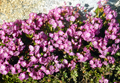
 Not giving up on a fine Sierra trip I decided to do an earlier solo hike in late July. I had always wanted to return to the Blue Lakes in the Ansel Adams Wilderness west of the Ritter Range. The Blue Lakes were surrounded by flowers and reflected the Minarets, worthy of a photo by Ansel Adams. Our group of SMS friends, led by Mark Goebel and myself, climbed Forrester and Ansel Adams. Thirteen years later I wanted to retrace part of this trip. It also served to scout out part of Tom's route to provide useful information. It turned into a trip of many surprises.
I left from my second home in the Bay Area on Wed, July 19 in 100 deg inland summer weather to Bass Lake, south of Yosemite N.P. From there a long winding mountain road (Beasore Rd) leads to the Isberg Trailhead. I made a detour around Bass Lake to pick up a non-reserved wilderness permit at the North Fork Ranger Station. When I mentioned my destination Blue Lake the ranger looked at me with some doubt and said everthing above 10,000' is still under snow. So what, did I think, I walked for days on snow in Oregon on the PCT.
 The Beasore Road is a 32 mi adventure of mountain road driving. Luckily it is well marked but it helps to have a GPS to stay away from the zillions of side roads. For the first 20 mi it is a paved winding road, then it gradually loses the pavement and becomes a potholed dirt road. I made it to the Clover Meadow Ranger Station just before it was closed. I had a short chat with the Ranger and he wished me luck with the trip. Then it was another 2 mi of potholed dirt road to the trailhead, which was no problem with my Subaru but forget about bringing a low clearance car. I spent the night in the car, all my food safely stored in bear boxes at the trailhead.
 Thur, 7/20, I was on the trail by 6am. Not a soul around on this remote trailhead. The Iceberg Trail climbs steadily to The Niche where it meets the gushing East Fork Granite Creek which drains Sadler Lake and higher terrains. Two fording of the creek are required.
One of them can be accomplished by balancing over a log, another one where the creek is wide and shallow and can be easily walked through, getting of course wet feet.
Thur, 7/20, I was on the trail by 6am. Not a soul around on this remote trailhead. The Iceberg Trail climbs steadily to The Niche where it meets the gushing East Fork Granite Creek which drains Sadler Lake and higher terrains. Two fording of the creek are required.
One of them can be accomplished by balancing over a log, another one where the creek is wide and shallow and can be easily walked through, getting of course wet feet.
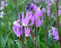
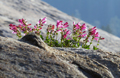
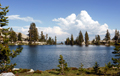
The next break is at Cora Lake, a pretty lake surrounded by forest. It would be inviting for a refreshing dip, were it not for hundreds of mosquitoes asking for a blood donation. The only solution are overdoses of DEET or to keep walking which I preferred. The trail continues to climb toward Sadler Lake. One passes along meadows filled with wild flowers, shooting stars by closer inspection.
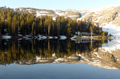
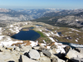
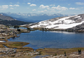
At the south end of Sadler Lake there is a sign to McClure Lake. In my memory it is still prettier than Sadler Lake. Since the trail requires another fording of the wide Granite Creek I walked around Sadler and climbed XC to McClure. It is indeed a wonderful lake in a cirque of steep mountain walls. In the distance I saw one fisherman, otherwise it was a place of solitude. Snow banks were hanging into the lake, explaining why the dip into the icy water was very short. Later I started fishing and caught some trout but they were only 6" short and I returned them to grow longer.
Since I had no time pressure I decided on Fri, 7/21 to make a detour to the Isberg Lakes. I followed the trail up from Sadler Lake to the first Isberg Lake where I hung out till lunch, swimming, loafing around and taking pictures. Life was good up there.
 In the afternoon I headed back east for my destination of the Blue Lake. It is all XC terrain. First, I ascended to McGee Lake south of Long Mountain. There I settled down for one night with the plan to climb Long Mtn the next day. The lake was above the tree line and had fewer mosquitoes. I swam and sun dried on the rocks until I heard many voices. It was a group of 15 youngsters with leaders from the Outward Bound School. Solitude was traded for fun communication. They came from all over the country. Some inner city kids have never seen mountains like the Sierras, leave alone to climb one. I caught one good size trout, but one does not make a dinner and I let it go again.
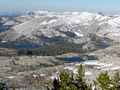
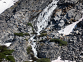
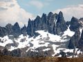 Long Mountain forms a formidable north-south barrier which one has to cross to continue east toward the next lakes, Rockbound and the Blue Lakes. The south facing slopes of Long Mtn had few snow patches so that it seemed plausible to climb over the ridge to the next lakes. Thus, on Sat, 7/23, I started at 6:30 am to ascend Long Mountain. It doesn't look much of a challenge but with a full pack it is a good work out. By 8:30am I was on the summit (11,502') and could not believe my eyes. The east and north slopes were all covered by steep snow fields. The upper Rockbound Lake had green-blue icy water. There was even a ski track in a snow field on the Long Mtn ridge. Seems that summer had not yet arrived up here.
 There was no safe way to descend to the Blue Lakes. It would require ice axe and crampons or skis but who would have brought them in mid summer, late July. There was some hope that descending south on the Long Mtn ridge would open up a snow-free gully, but it did not materialize. Maybe south of Sadler Peak there was a snow-free route down to Long Creek but that long detour was not worth the effort and there are many other pretty lakes in the area.
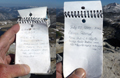
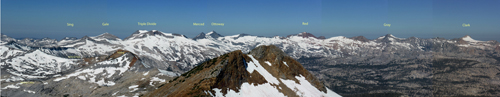
But the climb of Long Mtn was worth the exercise. Although the air was a bit hazy from wildfires in the Sierra Gold Country the views of the Ritter Range and the Minarets were impressive. To the west the entire Clark Range was visible. To the north one could also identify the Yosemite High Country with its many snow covered peaks. The peak register was only 10 years old. It had many signatures from Outward Bound groups who seem to have adopted this remote area.
 Being on this high point brought back many memories from previous trips, both in summer and winter. For example we skied the Southern Clark Range to the top of Triple Divide, we traversed on skis from June Lake to Badger Pass along the
Yosemite High Route, skied
Mt Ritter, and
in summer we climbed Clyde Minaret,
Ansel Adams, Foerster, Sing and Gale, and earlier I soloed Clark, Gray and Red.
Being on this high point brought back many memories from previous trips, both in summer and winter. For example we skied the Southern Clark Range to the top of Triple Divide, we traversed on skis from June Lake to Badger Pass along the
Yosemite High Route, skied
Mt Ritter, and
in summer we climbed Clyde Minaret,
Ansel Adams, Foerster, Sing and Gale, and earlier I soloed Clark, Gray and Red.
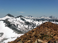
After giving up the traverse to the Blue Mountain I decided to go back to the area of the Isberg Lakes, Pass and Mountain. Thus after spending Sat night in the treeless, mosquito-free high country I returned on Sun, 7/24, XC to the Iceberg Lakes and did some fishing. On Mon, 7/25, I ascended the trail to Isberg Pass which offered a great view over all the pretty Isberg Lakes. There I dropped my pack and climbed Isberg Peak (10,996') along but below the southern ridge. I summited at 1:30pm and found a puny little register box deep under a large summit cairn. It had only one page signed by half a dozen groups with many youngsters (12 yrs). I had lunch on the top, enjoyed the views and took many pictures. To my surprise there was good cell phone connection so that I could call my family and send a selfie for reassurance. The wind had shifted and clouds moved in from the south. By early afternoon they billowed and formed thunderstorms in the Eastern Sierras and Nevada. This made great pictures. Later at night there was sheet lightning in the sky and by midnight big raindrops fell for a short time.
After descending from the peak I explored the trail beyond the Pass. The trail divides into one going north into Yosemite N.P. and another going south past Post Peak to Fernandez Pass. The same story repeated: South facing slopes are snow free, north and east facing slopes are covered with steep snow fields. Thus there was no point to balance on a snow covered ridge to Post Peak Pass. Well, one has to be satisfied with what Mother Nature offers. I returned down to the middle Isberg Lake where I spent the night.
 On Tue,7/25, I wondered what else to do. Since I could not go beyond the passes and had seen most lakes I decided to return. It takes a long day to hike out from the Isberg Lakes to the car. I slept at the trailhead and next morning, Wed, 7/26, I drove back to the Bay Area.
In retrospect the limitations by the snow coverage were part of the adventure one finds in the mountains. Mid summer felt like spring time. Wild flower displays were gorgeous. Rivers and waterfalls were running wild. Weather was great and thunderstorm activity was only a display. The only nuisance was the prime time for mosquitoes and stinging flies but half a bottle of DEET solved much of the problem.
In two weeks Tom Marsh's SMS group will venture into similar backcountry. I hope this trip description is helpful for planning their route. The snow conditions will be better, the rivers running lower and the mosquitoes less active. I wish everyone a great trip and look forward to hearing their stories.