
 This is a private trip report about peak climbing in the Austrian Alps, which could be of interest to any SMSr traveling to that area. It was my third time to spend a sabbatical month at the University of Innsbruck, in the midst of the
Tyrolean Alps. The weekends were free and it was perfect summertime in the high country. Well, I had to wait a little while since in mid-June it was still snowing above 2000m elevation. But within a week it turned into summer, one of the hottest they had.
This is a private trip report about peak climbing in the Austrian Alps, which could be of interest to any SMSr traveling to that area. It was my third time to spend a sabbatical month at the University of Innsbruck, in the midst of the
Tyrolean Alps. The weekends were free and it was perfect summertime in the high country. Well, I had to wait a little while since in mid-June it was still snowing above 2000m elevation. But within a week it turned into summer, one of the hottest they had.
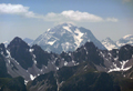
 All trips I did were day hikes, partly solo, partly with students. The first one went to the Solstein Mtn, a peak in the Nordkette above Kranebitten. I started at 6am and hiked on trail from the valley to the Rauschbrunnen (a mountain inn, still closed), then to the Kranebitter Klamm (a long gorge), ascended to the Magdeburger Huette (had a late breakfast), and via the Hoettinger Schuetzensteig to the Solsteins. This was a 2000m (=6,600') ascent. There are two Solsteins, a higher "Kleiner S." and a lower, easier "Grosser S." (2,491 m). My 70-year old body opted for the Grosser Solstein where I had a late lunch and almost the same view. I talked to others on the peak, enjoyed the grand views, took pictures and fed the crows. Glider airplanes and parasailers were cruising over the peaks.
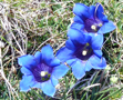
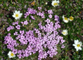
 In the early afternoon I descended over meadows filled with wildflowers back the same way. At the Huette I chose a short-cut, the Schleifenwandsteig, which meanders along the steep walls of the Hechenberg and then drops into the Klamm above Kranebitten. At some places the trail has steel cables since it passes through fourth class terrain. One also has to watch for rockfall, partly natural and partly released by Gemsen (mountain goats) above you. After this adventurous but long day I was ready for a cool Zipfer (local beer).
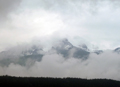
 On another weekend I was ready to go for another peak in the Nordkette (the chain of mountains north of the Inn valley near Innsbruck). One cannot plan these trips long in advance but has to listen to the weather forecast and go the next day. The weather can change rapidly in early summer and thunderstorms in the Alps are not to be taken lightly. My plan was to climb the Rumerspitze (2454m). It was too far away to day-hike it from the valley near Kranebitten. Instead, I saved time and energy by taking the cablecar up to the Hafelekarspitze from where trails lead along the crest.
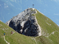
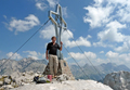
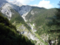
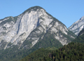
The "Goetheweg" goes east along the Nordkette, switching occasionally from the north to the south sides. The scenery is outstanding but you have to watch your steps while hiking since the slopes are steep. As I got over the Mandlscharte the Rumerspitze began to look quite impressive. The ascent from the west starts at the Arzler Scharte (2158m) and follows the west ridge of the mountain. Initially, it was easy, but then it narrowed to a knife-edge ridge without any steel cables. Instead, a memorial sign was posted for two young climbers who fell to their death at a precarious place. With this awareness I proceeded extra carefully and reached the summit safely. It was as good a climb as any cl3-4 climb in the Sierras. For a change I was alone at the summit cross.
 No need to mention the things one does on the summit, only that it feels great to be there, except for knowing that the descent is usually trickier than the ascent. But everything went smoothly on the way down. I met others who ascended the same way, and one who turned back after reading the sign.
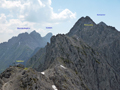
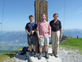
 On the way back, I had time to visit some other summit crosses. First I went up to the Mandlspitze (2366m) which offered a fine view back on the Rumerspitze. Next was the Gleirschspitze (2317m) and finally the Hafelekarspitze (2334m), which had as many visitors as sheep in the adjacent meadows. Then I took the lift down and the city bus home. It was another fine day in the mountains without being too exhausted.
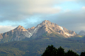
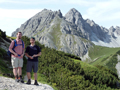
 Every time when I took a walk above Hoetting and saw the Nockspitze on the other side of the Inn Valley I thought of climbing it. On Sat, July 10, the weather was perfect for the hike and I was delighted to have company of the two students from our research group, Hannes Gruenwalt and Boris Fonda. We took an early city bus to Innsbruck, switched to a post bus to Axamer-Lizum, a well-known ski area with Olympic history (1964,1976). The Birgitzkoepflbahn had just opened and it was too attempting to get a lift up to 2000m. From there it was an easy hike up the gentle southwest slopes to the summit of the Nockspitze or Saile (2404m). Quite in contrast, the peak has a very steep face to the north which would probably require technical gear.
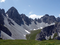
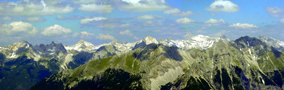
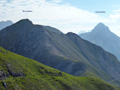
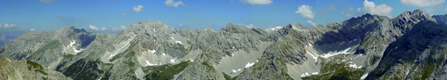
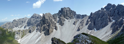 It is a very popular place and many people were at the summit and the second lower summit (2379) where we had a snack break, too. To the northest, one had a fine view over the Inn valley and Innsbruck toward the Nordkette. Even more impressive was the opposite direction with the rugged peaks of the
Kalkkoegel mountains. These resemble the Dolomites since they consist of the same rock.
Since it was way too early to return we decided to head toward the Kalkkoegels. They have many fine summits such as closest Ampferstein (2556m) and the highest Marchreisenspitze (2620m). But the trail signs warned that they are only for experienced climbers with harnesses, which discouraged some ambitions and we settled for hiking a loop trail, the Innsbrucker Almweg, along the mountain chain.
It is a very popular place and many people were at the summit and the second lower summit (2379) where we had a snack break, too. To the northest, one had a fine view over the Inn valley and Innsbruck toward the Nordkette. Even more impressive was the opposite direction with the rugged peaks of the
Kalkkoegel mountains. These resemble the Dolomites since they consist of the same rock.
Since it was way too early to return we decided to head toward the Kalkkoegels. They have many fine summits such as closest Ampferstein (2556m) and the highest Marchreisenspitze (2620m). But the trail signs warned that they are only for experienced climbers with harnesses, which discouraged some ambitions and we settled for hiking a loop trail, the Innsbrucker Almweg, along the mountain chain.
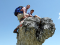
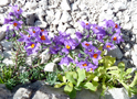
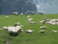 The trail was a roller coaster tour from one green mountain meadow to the next, separated by valleys, and populated by sheep and cows. It was a hot day and we did quite a few stops. Hannes and Boris scaled some mini-Dolomite rocks. On the saddles we took breaks and fully enjoyed the scenery. Eventually we ended up at the Hoadl where the cable cars for skiers ends. We walked down the Olympic downhill run, not on snow but through green meadows covered with a carpet of wildflowers. For the skiers it may have taken only minutes while it took us an hour to walk.
 At the end of the trip there was of course a "Jausenstation", an outdoors mountain restaurant for refreshments. This is the way many locals enjoy hiking in the Alps. Compared to the Sierras one may not experience the same feeling of wilderness in the Alps, but this is compensated by spectacular sceneries and challenging climbs. It is nice to experience the differences of two wonderful mountain ranges.
Back to Trip Reports
Back to SMS Home Page