
About three years ago I started thinking about skiing the Sierra High Route in a day. I was thriving on climbing and skiing big mountains in a day and the high route, at least on paper, looked like about twice the effort. A double day. A classic trans-sierra route. I was inspired.
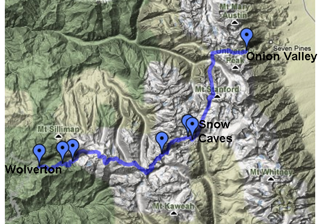
The Sierra High Route is the classic trans-sierra tour. Pioneered by Otto Steiner in 1931 and, in its current version, in 1975 by Dave Beck, it spans about 40 miles connecting the Eastern Sierra above Independence with the Western Sierra at Wolverton in Sequoia National Park. It never strays far from the crest, staying above 11,000' for almost the entire route and amassing ~13,000' of climbing. Most groups take about 6 days to ski it. Bob Akka skied it in about 20 hours and rumor has it that Doug Robinson also did it in under 24 hours (there are probably at least a handful of others). Bob and Doug both knew the route well. I knew only brief parts of it, mostly from summer backpacking.
My first attempt was scuttled before it began. The window of opportunity for Brad McHose and I required getting dropped off at the Shepherd's pass TH, crossing in a day, and directly hitchhiking to San Francisco for the wedding of my childhood friend JP. I'd need a clean change of clothes too. I didn't want to miss the wedding, so I cancelled the crossing.
By the second year Don Sutton was on board, but I had to finish writing my Ph.D. dissertation so Don tried it solo. He planned to cross in one day, stay at the Wuksachi Lodge in Sequoia NP, then ski back to his car in 2-3 days. It hadn't snowed much that spring and when Don surmounted Shepherd's pass he found nasty shark fin snow stretching for miles across the headwaters of the Kern. He wisely judged it impossible to cross quickly and retreated.
In year three the stars aligned. I met Scott Siegrist on a trip to Red Slate Couloir and learned that he and Ryan Franz wanted to do the HR. We coordinated our schedules to go opposite directions and swap cars. Don and I would ski East to West, but would start at Onion Valley (instead of the Shepherd's pass trailhead) so that Scott and Ryan didn't have to walk down 4000' at the end of their trip. I knew the Onion valley start would complicate things, but only later found out how much.
Onion Valley (9200') is one of those glorious high country trailheads full of pines, a roaring creek, towering peaks and, when we arrived at 11:45 p.m. on April 21st, a sky full of stars. We decided to sleep for a bit and by 1:30 a.m. we set off.
Starting in Onion Valley doesn't alter the total elevation gain or mileage much compared to Shepherd's pass, but takes you through some 'very wild' terrain according to John Moynier's guidebook. The night was warm and as we set off for Kearsarge Pass we postholed through soft snow, bushwalked through shrubs, and postholed some more. Gradually the snow coverage reached 100% but we continued walking on hard snow up to the pass, ready for our first backcountry descent. Headlamps on, we dropped gloriously into the backcountry, scratching our edges into the hard snow as the first bluish ribbons of dawn sallied forth. Exhilarated, we careened down the valley rolling over rises and darting between pines all the way towards Bullfrog Lake, which we skated across, then picked our way downhill to Vidette Meadows, skiing a bit, but mainly walking and bushwalking down the dry south-facing slopes.
The birds were chirping in the dawn light and we decided to whip up some oatmeal, coffee, and tea for breakfast. We had ~5 hrs in our legs already but unfortunately we were behind schedule due to the slow conditions on the way up Kearsarge Pass and down to Vidette Meadows. As consolation, the peaks rising above Vidette Meadows were gorgeous in the early morning light and it was something special to be that far in the backcountry already.
We put skins on our skis and headed up Vidette Creek towards Harrison Pass in the warm morning sun. All along the west and east faces of the canyon were avy debris from wet slide point releases from the previous days, which had set records for high temps. Would we have to take care with wet slides this afternoon? Or would it stay cool?
At this point I was feeling a little weak from the lack of sleep and altitude and didn't have a big appetite, which slowed me down. We followed a skin track up to a steep headwall that formed the headwaters of Vidette Creek. Don cramponed and I kicked steps up and out onto the ridgeline. Up top we surveyed the cirque below the west flank of Mt. Stanford, popped our skis on, and hollered as we careened down on smooth corn, then traversed high across the other side to approach Harrison Pass.
Skinning up Harrison Pass my Dynafit ski binding broke. One of the toe pins was loosening and it just broke out. I put it in my pocket and switched to crampons to crest the pass. Up top I duct taped the pin in place, snapped into the bindings, and Don and I descended into the Kern River basin. (I wasn't worried about the toe piece while skiing downhill because with both toe and heel locked there's little torque.) What a thrill! It was snowing lightly in some parts of the basin and we spent about an hour and a half gliding downwards between the towering 14ers to the east and great western divide to the west, down into the forested banks of the upper Kern. By the time we reached our turn off into Milestone Creek I was hammered. Sleep beckoned. My stomach still felt a little funny. I needed to shut my eyes, relax, and spend an hour slowly eating and drinking. But we didn't have time. It was snowing. It was already 2 pm. We'd been moving for 13 hrs. Don was feeling well and we set off again but I didn't have the energy. After 20 mins we decided to relax for a while.
I brewed up some chili and peppermint tea and felt much better. The sun came out. We napped for an hour or two. Milestone Creek was a fine place to camp with lots of running water and relatively low altitude (~11,000' where we were), and we decided to settle down for the night. We moved up valley a bit and it started snowing so we dug snow caves. It cleared up pretty quickly. I spent a warm night in my snow cave, sleeping in a "35 degree" down bag on a closed cell foam pad, with a little view of the stars. Don had an air mattress that insulated poorly so although he had a good sleeping bag he spent a cold night..
At 4:30 a.m. I awoke and got out of my bag to wake Don, but he asked to wait until daybreak; it was cold enough that I started shivering within minutes - and jumped back into my warm sleeping bag! Around daybreak we set off but almost immediately Don bonked. He had used a lot of energy staying warm (and shivering a bit) through the night. We spent 20 minutes eating and drinking then set off up Milestone Pass. Dark lenticular clouds soared over the 14ers of the eastern crest like a giant battleship, but the sunlight kept us warm. Atop Milestone Pass we clicked in for the descent of Milestone bowl, which is overlooked by the regal Kaweah's. The views were unsurpassed, but the shaded bowl was full of hard, convoluted, and runneled snow. On the descent the skis chattered badly and almost immediately my skis popped off! Where was the toe pin?! I looked and found it quickly. Better ski very conservatively, I thought. And lock both bindings so no ski can fall off.
At the bottom of the bowl we cruised across early morning corn in this now sunny Sierra backcountry playground. Mysterious storm clouds played with sunshine in the distance. We melted snow and made oatmeal on a warm rock, and I gave my bindings an A+ duct-tape job. They held perfectly up over the next pass. For the rest of the day I would somehow knock out the pin about once per pass (there was no rhyme or reason to this), pick it up somewhere right under my nose, jam it back into its duct-tape fortress, and snap the bindings back on.
While I was dealing with my binding and trying to eat and drink enough, Don was motoring ahead. He seemed to have no problems at all and I was happy he could play leader and monitor the GPS and maps. We were fortunate to have an excellent skin track to follow - laid down by a previous party. With each pass we'd crest, we'd stand above some enormous cirque or basin - the headwaters of an important Sierra river. Normally ski mountaineering features exciting descents, but we traversed high around these features to keep our elevation. Cloud Canyon and Deadman Canyon are impressive and enormous - so much so that our friends Scott and Ryan (skiing the opposite direction) looked like tiny ants traversing an empty swimming pool.
Late in the afternoon we were eating wet snow to hydrate and making our way slowly up to the Tablelands with views below us of Valhalla with the Kaweah's above. I was moving at a conservative pace, feeling tired, but Don was going strong. Finally we crested the Tablelands then skied downhill for about an hour to the Pear Lake area. I dreamt of ducking into the hut for a warm meal and drinks, but Don mistakenly set off contouring (yet again) around the drainage. Since we'd kept our elevation (and it was already 6:30 p.m!) we decided to skip the hut and hit the "go" button one last time, heading straight for the last hill - "the hump."
Just below the hump we chanced upon 5 skiers sitting around a luxurious camp kitchen and blazing tunes from their ipod! They 'did unto others...', giving us warm water and snacks like Cliff Shots and caffeinated Sport Beans! Within 30 seconds I was lit up, completely back to 100% rearing to go and Don was looking great too. (If only I could buy those guys a beer!) We crested the hump as dusk settled on the Sierra and cranked up the headlamps for the ski descent through the forest. What a blast! Weaving between trees and over rollers we darted from one reflective trail marker towards another. As we descended through the sequoia forest the snow thinned and we walked the last two miles or so. From time to time I'd switch off my headlamp to gaze with wonder at enormous pines towering towards the night sky. Around 9:00 p.m. we reached the parking lot, changed clothes, popped open a beer, and drove home. To top it all off, on the drive down through the giant sequoias into the foothills we saw a mule deer, a grey fox, and two bobcats - one crouched down beside the road and one darting across it!
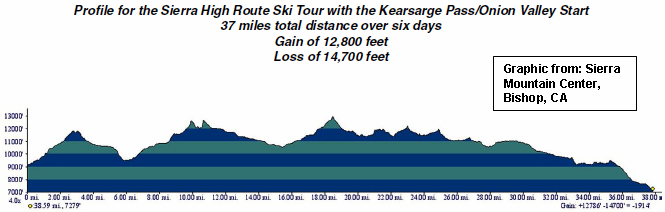
In reflection, The Crossing was an unprecedented, monumental adventure for both of us. The shear number of passes crossed gave a sense for the Sierra's size measured in footsteps and heartbeats, while the multiplicity of Sierra vistas, constantly changing, made it clear that we'd barely scratched the range's surface. While we planned a sub-24 hour crossing, we actually spent about 13 hrs the first day and about 15 hrs the second. The first part of our route was more complicated and time consuming than the Shepherd's pass approach (our original plan); my binding problems slowed us down; sleep deprivation and altitude weakened my stomach (but not Don's); I'm sure we could make it in a day from Shepherd's pass if everything went right-and maybe we'll do it someday (although there are a lot of other beautiful Sierra tours to do!)-but that doesn't really matter. What matters is that we went boldly on a beautiful adventure, dealt with the unexpected, and came away successful, humbled, exhilarated, and strong.
Our route (GPS) and SPOT signals on Google Terrain Map
|
|
|
|
|
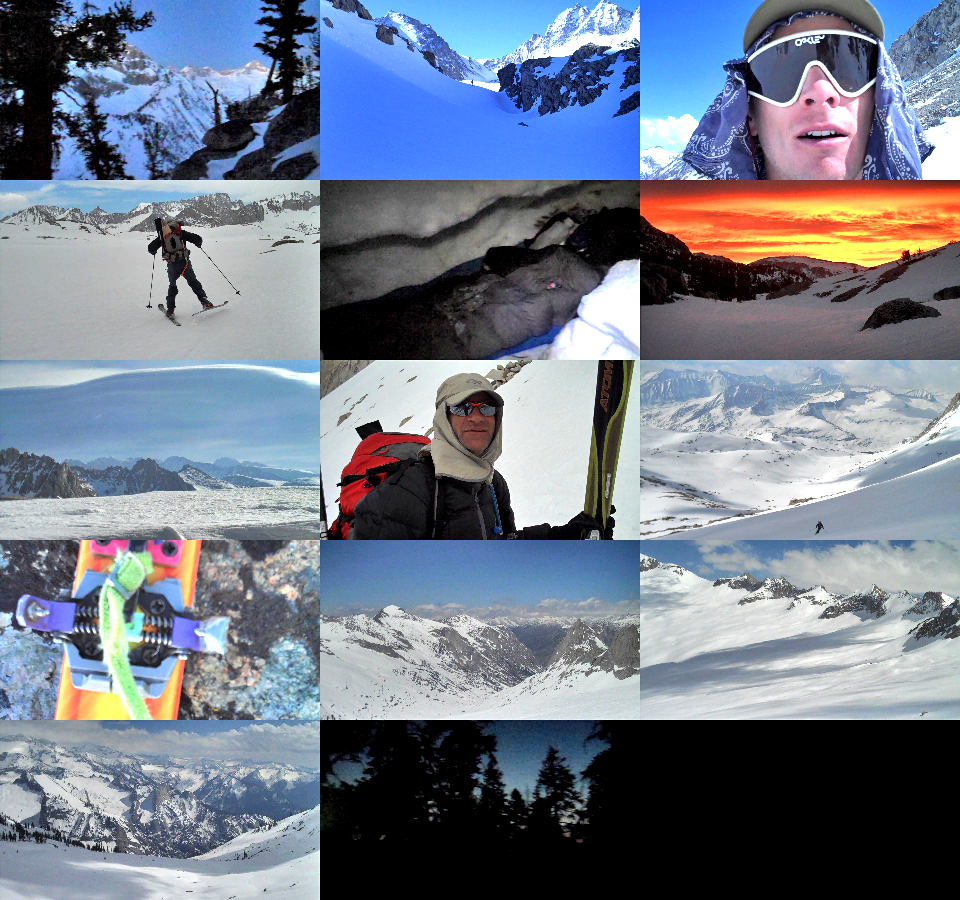
Photos (left to right, top to bottom): looking from Bullfrog lake across the Bubbs Creek drainage at dawn; skinning up the Vidette Creek drainage; Scott feeling good around 10 a.m.; Don skating across the headwaters of the Kern towards Milestone Mountain; a comfy snow shelter; sunrise along Milestone Creek; giant lenticular clouds to the NE; Don about to ski down Milestone Bowl; Don skiing down towards the Kaweah's; duct-taped Dynafit toe pin; Cloud Canyon; upper reaches of Deadman Canyon; looking S towards Valhalla; the forest at dusk while skiing down into Wolverton.
Back to Trip Reports
Back to SMS Home Page