
|
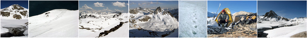
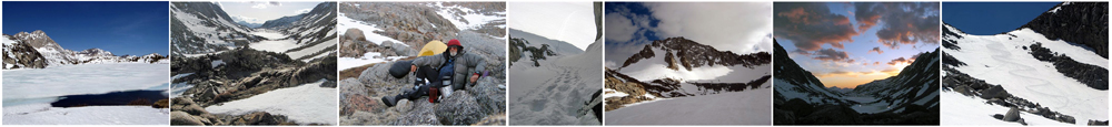
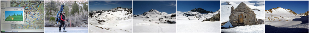
Deep in the heart of the Sierra are a number of high priority peaks for the adventurous ski mountaineer. Access to them by skis requires days and commitment in order to surpass their barriers and distances. Highest on the list for this tour is Mt. Goddard at 13,568 feet that is accessed from a base camp at Muir Pass then via Ionian Basin that is over Solomon Col and across a long series of lakes that lead to the slopes and ultimately the summit. Nine days of supplies had been put together to accomplish the first goal and the many other climbing and skiing goals along the way. The route started a Lake Sabrina and headed to the Sierra crest south of Mt. Darwin. After climbing and skiing with a 53 pound pack for 12 hours that first day, I reached Echo Lake that was solidly frozen over and a good sign for the rest of the trip. The remoteness was beginning to sink in as I took in my steep, wild and, in some ways, intimidating surroundings where everything appeared straight up. My first camp near the edge of the lake was pleasantly cool, slightly windy and in an excellent position for an early assault on the crest via Echo Col the next morning. After a satisfying breakfast, it was time to buckle up the crampons and ascend the steep, solidly frozen slope to Echo Col. Stepping up to the edge of the col opened up views of the Sierra that only the heartiest ever get to see. At that point, I also had to slightly repack in order to down-climb the upper 100 feet of exposed, 3rd and 4th class rock on the very steep west side of the col in order to get down to skiable snow again. By late morning, the snow had ripened nicely, making my descent down into Le Conte Canyon a treat that any skier would find a total joy. As I approached the bottom and traversed as much as possible to avoid excessive elevation loss, I set my day’s goal to reach Muir Pass that is the highpoint in the long valley that separates Le Conte Canyon from Evolution Valley, where the watershed drainage leads in opposite directions. At the pass is the Muir stone hut that was built in 1930 by the Sierra Club to offer shelter for anyone caught out in the elements. It was empty and open and I decided to use it as my base camp for the many nearby peaks that I wanted to climb. I slept well and got an early start on what I expected to be a long day to reach the summit of Mt. Goddard. Solomon Pass was a steep 600 feet above the hut that warranted crampons then descending down 1,000 feet to the first of a series of lakes on frozen but moderately pitched slopes was just more of the fun of being out in this wild country on skis. The series of lakes were frozen early in the day and I was able to take a direct route over them and the undulating terrain that brought me to the view of Mt. Goddard and its mirrored reflection in an area of open water just in front of the peak. Impressive! I continued across the last long lake at 11,951 feet and up the east to northeast slopes. It seemed as if it didn’t take that long before I was at the top and ogling the views. I was thrilled! It was time for a lunch break followed by getting ready for the descent that would be in ideal springtime snow conditions for the next 1,500 vertical feet. I varied my turns from short, tightly linked parallel to carved parallel to drop kneed tele turns and back again as only a tele equipped skier can do. My quads got a very satisfying burn as I approached the bottom of this wild and remote mountain to glance back at my track that I knew would remain there unblemished until enough days had passed for the sun, wind and freezes to bring the silky snow texture all back into pristine uniformity once again. On my return across the lakes later in the day, I was considerably more cautious as there were many areas of standing water around the edges of the lakes and I gave them broad berth. From the base of the last 1,000 foot climb to Solomon Pass, I took a reflective look at what I accomplished and where I accomplished it and how I accomplished it – solo -- and felt good! On Solomon Pass, it was only about 600 vertical feet to the summit of Mt. Solomon that I knew I could make in the remaining daylight and was soon on the top basking in the very late afternoon glow. The steep face slope I was planning to ski was now in the shade and the snow was crusting up. Cautiously, I got off the top traversing the hard pack until I got down to softer snow where I completed many fine turns on my way back to the hut. Early again the next morning, I was on my way to the Black Giant that had been the next highest peak priority. It was a colder day with a light wind blowing keeping the steeper slope frozen. At the summit, I gained an excellent perspective on other peaks that I wanted to do and the best route to them and my choice for the rest of the day was Mt. Fiske. The descent off the “Black Giant” was on textured ice that was really quite fun as it propelled me quickly over a lot of terrain in my desired direction. Heading up the irregular geology on the south mini-cirque side of Fiske got me up to a high, steep bowl where I had to leave my skis and proceed through the very steep mixed granite blocks and snow on foot. This approach turned out to be very challenging as I often hit deep, soft pockets where I sunk up to my hips or waist then crawled out on to exposed 4th class sections of rock where I had to pause to regain my strength. This tested my mental will as it went on much longer than I would have liked and the risk was substantial. When I reached a high plateau, the peak was far to the west yet a pretty straight forward hike over breakable patches of snow. On the summit, I thought to myself that I really earned this one and also decided I would find a better way down which, fortunately, I did. |
Back at my skis, the snow and slope were just right for laying down a photo-quality track right through all the geological features to the lake where, again, I proceeded with some trepidation due to the softening of the snow and ice permitting my poles to punch through to water in some places. Relieved to be off the lake, it was somewhat more than an hour tour uphill to my base at the Muir Hut. Having accomplished most of my climbing goals in the immediate vicinity, it was time to pack everything and start heading north with one exception -- Mt. Warlow. Another early departure and a stop with the full pack at the base where I proceeded up a nice firm slope with my day pack toward the top of the snow very near the summit where I reveled in the glory of another new mountain. The steep snow descent was as fun and as good as it gets and it was finally time to heft the big pack and head down into Evolution Valley where to my complete surprise in this deep area of the Sierra I encountered a solo skate-skier coming toward me with the lightest of lightweight gear. We stopped and exchanged stories. Peter’s mission was to do a long, one day, double marathon loop deep into the Sierra and out. We wished each other well and headed off in our respective directions. Considering it was still early in the day and I was in no rush to leave this area, I decided to leave my big pack next to Wanda Lake and make another run on Mt. Warlow - it was worth it as conditions were exquisite and I knew my chances for any other summits would be very limited. Following Evolution Creek to a high, exposed rock bench above Sapphire Lake, I decided to make my camp on this rock outcrop with a fine view of the valley below. One big motivator for this seemingly high early stop was the fact I had seen at least three separate sets of bear tracks that I figured would be headed to lower vegetation-abundant areas since I wasn’t prepared to do any bear proof food storage thinking I am on a winter trip when bears are still hibernating. The reality was that they were just starting to wake up as it was already late spring. I spent another night enjoying all the splendor and tranquility that the mountains can bestow and perhaps experienced the Bedouin proverb “When you sleep in a house, your thoughts are as high as the ceiling; when you sleep outside, they are as high as the stars.” As I started out in the early morning, the snow bridges were solid; yet there were areas where the river gushed out of the snow and rushed down over the rocks creating water-wheels that would delight anyone who had a passion for seeing Nature express its springtime exuberance. Further downstream just before Evolution Lake at 10,852 feet, I had to make my crossing on thin ice to head up into Darwin Canyon that was my planned route. Darwin Canyon with a series of nearly frozen-over lakes in a deep exposed rock gorge with no vegetation was the ultimate in wild-looking places. At the upper end of the canyon and opposite Mt. Darwin and its spectacular glacier, I set up an ideal base camp for attempting Mt. Darwin the following day. I reviewed the write-ups on approaches to climbing Darwin and felt I had a very good chance. Considering that to me summiting Mt. Darwin at 13,831 feet has a much higher priority than just skiing glaciers, my direct approach to the notches that are supposed to be 3rd class and to the far right of the main couloir were where I was headed first thing in the morning. On approach, the snow in the sun was already softening and when I got within the shadow of the higher notch, I encountered cold wintery snow that I climbed to its upper limit where I was stopped by 4th and 5th class rock. The second notch had the same limitations; so, I decided to ski a long traverse all the way across the glacier to attempt the left shoulder that got me partway up and to another stalemate. The main couloir was my last option and up I went kicking steps in cold, firm pack snow to what I thought was the highest finger that would ultimately head to the summit. I reached an altitude of 13,630 feet just about 200 vertical feet below the summit where I was stumped again even though I spent over an hour working options at that level when I finally decided the risks for a solo climber with no protective equipment were too great. I descended down to my skis on about a 40+ degree pitch of the couloir on smooth-packed powder and worked my way down to a point where I had some fun turns. My thoughts were temporarily dominated with disappointment for getting so close after putting in so much effort and not making the top -- but this is not the first time this has happened on big mountains and I plan to go back for another attempt by different approaches or different strategies or both. Back at camp, I reflected again on what I experienced and accomplished in the past 8 days including savoring the very remote location I had to myself that evening that was all a part of the burning quest I had to solo ski and climb those mountains deep in the Sierra. The last day was a leisurely climb over Lamarck Col with some fun skiing and a lot of hiking back to my truck at Lake Sabrina. So at last for me, I had a great time and look forward to spending more time climbing and skiing more mountains in the deep and wild Sierra. Below are some pictures from the trip: |