
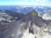
Francis Farquhar (12,893')
Friday morning we assembled at Road's End (Kings Canyon NP) for the hike up to Sphinx Lakes. Because of outside commitments the outing had been shortened by one day; Mt. Francis Farquhar was selected as our goal. The route begins on the flat, sandy trail along the South Fork Kings River heading towards Bubbs Creek.
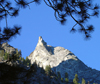 The six of us (Fred Gabbard, Diane Purkey, and Jim Crouch from San Diego Chapter; Steve Curry, Reiner Stenzel, and Ted Tassop from Angles Chapter) enjoyed the mild morning (departure before 8:00 am) temperatures. Once we left the South Fork Kings River we began climbing. As we climbed up into the Bubbs Creek canyon we had good views of the Sphinx high on the south wall.
At the junction with the Sphinx Creek trail we found the footbridge was gone. After working our way across a still active creek, we asked one of the fellows working there "What took out the bridge?" to which he replied "We did. We blew it up a couple of days ago." This was one of the last all-wood bridges and the timbers were rotting. The bridge is being rebuilt with sturdier materials. (On our hike out we met a mule train carrying large planks for the bridge tread.)
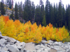
 We soon settled into a pace for the long climb up to the junction with Sphinx Creek. The initial portion of the trail climbs the steep rock face to climbers left of the creek, eventually becoming switchbacks through forest. The trail makes the transition from Black Oak and conifer woodland to lodge pole forests.
At the trail crossing of Sphinx Creek we abandoned the trail for cross-country travel along the creek over talus and slab benches, through forest patches up to the first Sphinx Lake (10,514').
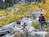 Those with heavy packs suffered during the long climb from the South Fork Kings River. Along the way clouds built up and "spit" on us a little; our morning sunshine was replaced by gray clouds and cooler temperatures. Soon after arriving, our camp had been setup and we gathered for dinner to chat and discuss our next day's objective.
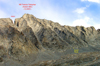
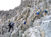
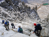
 Our Saturday morning departure was set for 7:00 am and we approached the mountain with several stops to get a look at the South West face and the several chutes that cut it. One chute seemed to have a climbable entrance and lead high onto the face.
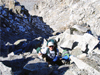
We tackled this one and went into steep terrain. This chute must be active during the winter because there is little loose rubble on the cl3 slabs and ledges in it. After a false start going straight up, we found that by crossing right into the next chute we could work our way up to the South ridge-this brought us to the cl2 slope on the East side of the ridge and an easy way up to the summit.
Our Saturday morning departure was set for 7:00 am and we approached the mountain with several stops to get a look at the South West face and the several chutes that cut it. One chute seemed to have a climbable entrance and lead high onto the face.
We tackled this one and went into steep terrain. This chute must be active during the winter because there is little loose rubble on the cl3 slabs and ledges in it. After a false start going straight up, we found that by crossing right into the next chute we could work our way up to the South ridge-this brought us to the cl2 slope on the East side of the ridge and an easy way up to the summit.
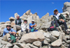
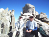
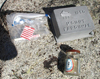
 The Sierra Register Committee had placed a register box in 1990; the box had no book. The register was in glass jar (No, it didn't fit inside the box.) and dated from the early eighties. From this register it appears that about one party per year visits this summit.
 The class 4 summit block was also climbed after descending through a gap and reclimbing the block from the west side. This is a wonderful area and this is a worthy peak.
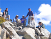
![]() After an hour and forty minutes on the summit enjoying the sun, good weather and expansive views we descended as we had climbed. Reiner had strategically placed a few ducks along our route, which helped retrace our somewhat circuitous route and avoid our earlier missteps--after a while all chutes begin to look alike. We found and removed most of the ducks as we went; those we missed won't survive the winter snow in this steep chute.
After an hour and forty minutes on the summit enjoying the sun, good weather and expansive views we descended as we had climbed. Reiner had strategically placed a few ducks along our route, which helped retrace our somewhat circuitous route and avoid our earlier missteps--after a while all chutes begin to look alike. We found and removed most of the ducks as we went; those we missed won't survive the winter snow in this steep chute.
 We returned to our camp about 3:15 pm. As we had all agreed, we all signed out ending the Sierra Club outing. Reiner headed down to the trail and was in 3 hours at the Sphinx-Bubbs Creek junction where he spent the night. Next day he got an early start toward home for a Monday work commitment. Within an hour or so the clouds, that had been gathering since we left the summit again, "spit" on us; first thunder, then graupel and some snow flakes - didn't amount to much. We did camp chores and had a leisurely dinner.
North Guard (13,327')
At 7:00 Sunday morning those of us that remained (including two others leaders from San Diego) headed over the col from the Sphinx Creek drainage into the Brewer Creek drainage to climb North Guard.
 After circumventing the spur immediately east of the col, we followed the creek up toward the saddle between Mt. Brewer and North Guard. After spending some time trying to relate climb descriptions to what was before us, we selected a likely chute and began climbing. We eventually found the "sandy bottom" chute and correctly followed it up and then worked our way right, then climbed up to the summit area. We gathered in a large alcove just below the summit rocks. From there we took turns climbing up among the rocks to reach the ammo-can to sign the register.
We descended, initially as we had climbed, but deviated lower down and eventually reached the easy terrain below. Steve and Ted wished to climb Mt. Brewer and headed over to make an attempt. Diane, Fred and I headed back to camp; arriving about 6:30pm as the sun was setting. Steve and Ted returned at about 9:45 pm after climbing (stopped by snow on the northerly exposure) to within a few hundred feet of the summit.
Monday morning we packed up and headed out the way we had come. As we drove out of Kings Canyon we could see the clouds that had been building in the morning were dark and storming, especially over the Middle Fork. All in all we had had good weather and were escaping before what looked liked some serious precipitation. In Bakersfield we all met for dinner a short distance to the west of US99 on California Ave. at the salad bar restaurant.
This was another great fall outing in the Sierra. My thanks to all that participated and to Reiner for assisting the SMS/SPS part of the outing.
Back to Trip Reports
Back to SMS Home Page