
In an ongoing quest to ski some of the less well known destinations in Southern California via some of the less well-traveled routes, I asked Scott Bornheimer to join me in this attempt to bag the Dragon's Head, located approximately one air mile south of Old Gray Back in the San Gorgonio Wilderness that is part of the San Bernardino Mountains.
We carpooled up to the Vivian Creek trailhead at 5,900 feet and were impressed by the deep snow base that was showing along side the road. The parking area was surrounded by at least 2 feet of snow. Despite that, we started out by securing our skis on our packs in anticipation of the 1000' vertical hike up the dry, south-facing Vivian Creek trail. Within less than a quarter mile at the point where the trail crosses the Mill Creek drainage, we were impressed by the relatively smooth and gently slopping terrain that is normally a minefield of large boulders 2' to 4' in diameter.
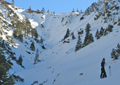 Under these special new circumstances and knowing that there was a point upstream called Mill Creek Jump-off which suggested there was a headwall, we decided to risk taking this more direct exploratory route figuring that we would find a way over or around it. Skinning up to the headwall offered an excellent perspective of a number of north-facing ski lines to be used in the future that were coming off the East/West ridge leading up to Galena Peak.
On the way, there were a few minor river crossings with only weak snow bridges that were a little threat compared to the bowling alley of constantly falling rocks that we had to go through to get on the steeper pitches of the jump-off. In early to mid-morning when the sun starts to warm up the high upper edges of the valley snow pack, the frozen bonds that were holding the eroding earthen cobblestone walls in place begin to weaken and release a steady rock fall that had created many sharp divots in the hard pack and a colorful gem mosaic that accumulated in the central drainage. Moving quickly and keeping a sharp eye out for any fast-flying rocks coming our way was the highest safety priority in this section of the valley.
Once on the icy steeper pitches of the headwall, the rock fall diminished and areas of slab ice became an issue as I was unable to kick any toe holds. Stopping to put on crampons at a lower angle was not an option due to the rock fall and now, at this steeper angle while on thin ice, the crampons still stored in my pack remained a non-option. Scott had taken a line up a slightly more sun-exposed aspect and was able to kick in toe holds that gave me another option -- down climb about 30 feet and traverse to his line where I could penetrate the wind pack with my self arrest poles and continue up then over the highest edge of the jump-off where we were able to stop for a break.
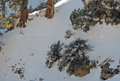
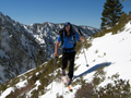 At this point, we started skinning across some shrubs that barely protruded out of the snow. We continued traversing using switchbacks up some open drainages in a mature pinyon tree forest that allowed us to establish a rhythm that set my mind free to thoroughly enjoy the wilderness setting we had immersed ourselves in. After the two drainages, I was thinking that it was pretty much straight up, until we wrapped around to a more north-facing aspect and saw a much steeper and deeper drainage that we would have to drop down into. At this time of year -- mid winter -- the snow does not uniformly soften up and we had to proceed cautiously across an east-facing, exposed, icy section before we could reach the bottom southwest-facing flanks of the Dragon's Head. The route was clear from here and after many switchbacks through variable snow conditions, wind-sculpted trees and rock outcrops -- we reached the top at 10,866 feet!
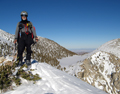 The effort up was very worth it. There were spectacular views to the west, where we could see San Clemente and Santa Catalina Islands through remarkably clear air over Riverside and Los Angeles - a rare atmospheric treat. To the southwest was Mt. San Jacinto with its prominent clean snowlines down into Snow Creek that I have climbed and skied in previous adventures. And to the east was Bighorn, Josh's Tarn, and one of the steepest and most complex couloirs right at my feet that would challenge the most extreme of extreme skiers. Old Greyback and Jepson Peaks were immediately north of us.
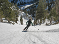
 After savoring our location and the perfect weather for this magnificent day, at 4:00 p.m., it was time to start heading down. The south-facing slope had spent the day ripening in the sun and it was time for us to harvest it. I started linking some turns in and around some sturdy, wind-weathered pinyon and cedar trees near the top on a solid snow base on the Dragon's south-facing tail in perfectly ripened spring-like corn snow that put me in a very euphoric state. Scott followed then proceeded ahead in his faster parallel beat that switched to fast arcing turns that fluidly carved around the lengthening late afternoon shadows cast by the sparingly placed individual conifers of this mature and healthy forest.
 We traded this sequence of initiating first tracks between us for at least the first 2,000 vertical feet into narrowing couloirs that bent around blind corners to a point where I heard Scott saying something in an unusually excited voice when he was just out of sight below me. I continued down to where I could see Scott pointing in the direction of what looked like post-holes across a steep, open pitch of the snow and shouting "Bear!" It didn't quite register on me just what had happened, but Scott clarified it when he said he almost ran into about a 200 pound black bear that he looked square in the eye before it ambled off into another parallel couloir before I could get a look at it. What a rare treat it was to inadvertently come so close to our big Southern California wildlife while skiing in mid-winter in our local mountains.
 We continued down our narrowing chute to a point where it suddenly dropped off at a waterfall. Fortunately, there was a way to down-climb around the side of it and continue lower. There was a point at least another 100 feet below in the narrowing canyon that looked like the top of another waterfall. We decided to take a slightly uphill traverse across an icy pitch to avoid skiing below the east side of the headwall. The snow was getting hard and icy on the north and east aspects we were traversing around and now that the sun was about to set we were thinking about the snow conditions in that headwall.
The traverse down the rest of the way to the top of the headwall through some brushy terrain went slow and now the sun had just set. Fortunately the headwall was like a big parabolic solar collector oriented to catch the day's last rays of the sun and when I skied up on the hard, east-facing edge and reached over the face to test the snow condition -- I was delighted. The weather had been perfect all day and now with no chilling wind the snow was still excellent corn.
 We entered through a horizontal break between the rocks at the top of the headwall and reaped a bounty of fun spring-like corn condition turns until we got to that rock-fall section where we stayed high and straight-lined through to minimize our exposure. About a quarter mile down the drainage we heard a helicopter and looked up to see that it was for searches and rescues. The pilot or copilot must have caught our movement and made one big circular flight around us as I'm sure they were wondering who or why anyone would be up this creek at this time of day. The only way Scott or I knew how to tell them we were OK was to continue skiing, which we did and they apparently got the message and flew off.
The snow began to firm at this point and skiing down the gently rolling moguls was a total pleasure until the light totally faded. We stopped momentarily to break out our headlamps and with our limited but regained visibility enjoyed a pleasurable ski all the way back to my truck.
The climbing and skiing day ended much as it started with high spirits and broad smiles except that we now had a new story of a great wilderness experience to share with our friends.
Back to Trip Reports
Back to SMS Home Page