 This was our summer Sierra trip along the Roper High Route from Cedar Grove through the
Cirque Crest returning on the John Muir Trail and Woods Creek. The trip was organized by
Tom Marsh and joined by seven friends from the Ski Moutaineers Section.
This was our summer Sierra trip along the Roper High Route from Cedar Grove through the
Cirque Crest returning on the John Muir Trail and Woods Creek. The trip was organized by
Tom Marsh and joined by seven friends from the Ski Moutaineers Section.
After reading Steve Roper's account of the Sierra High Route, the idea of doing the first
part of the route through the Cirque crest and then returning via the John Muir Trail and
Woods creek was appealing. A cirque (French, from the Latin word circus) is a theatre-like
valley formed by glacial erosion. Having been covered by glaciers many ions ago, the
Sierra Nevada range is striking in the size and frequency of these polished works of art.
The Cirque Crest route is arguably one of the best examples of this cathedral like
phenomenon. So much so, that early explores of the Sierra Nevada, like Joseph Le Conte,
named a lake along the route in memory of his wife, Helen Marion Le Conte.
 The route is rarely visited. In fact, we only saw one other person along the whole cross
country portion of the route.
This may have something to do with the first day. Starting
at 5,000 feet in Cedar Grove, the Copper Creek trail rises steadily some 5,500 feet in
about 9 miles to the closest overnight camping area at Grouse Lake. A daunting first day
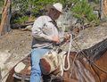
with packs full of nine days of food and other provisions. Luckily, Cedar Grove has a
packer that was happy to carry our heavy packs up to the final turn off to Grouse Lake
some 5,000 above the trailhead.
The route is rarely visited. In fact, we only saw one other person along the whole cross
country portion of the route.
This may have something to do with the first day. Starting
at 5,000 feet in Cedar Grove, the Copper Creek trail rises steadily some 5,500 feet in
about 9 miles to the closest overnight camping area at Grouse Lake. A daunting first day
with packs full of nine days of food and other provisions. Luckily, Cedar Grove has a
packer that was happy to carry our heavy packs up to the final turn off to Grouse Lake
some 5,000 above the trailhead.
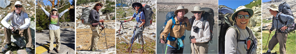
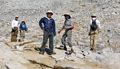
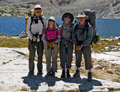
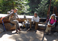
 Eight of us showed up at the pack station in Cedar Grove at 6:45am on Saturday,
August 6th to deliver packs and meet again. The group included May Adachi, Sung Byun,
Reiner Stenzel, Ken Deemer, Brian Deemer, Kat Seiple, Stan Huncilman and myself.
After dropping off packs and paying the packer, we drove the remaining 6 miles to
Roads End to obtain the permit and start our journey. We started off with daypacks
at a fast pace.
Eight of us showed up at the pack station in Cedar Grove at 6:45am on Saturday,
August 6th to deliver packs and meet again. The group included May Adachi, Sung Byun,
Reiner Stenzel, Ken Deemer, Brian Deemer, Kat Seiple, Stan Huncilman and myself.
After dropping off packs and paying the packer, we drove the remaining 6 miles to
Roads End to obtain the permit and start our journey. We started off with daypacks
at a fast pace.
 The first part of the route is long and relative hot until you reach the higher elevations.
It took quite a bit to get to Grouse Lake that day given the amount of climbing even with
just day packs. Because we quickly transitioned from the oxygen rich lower elevations to
the thin air over 10,000 feet, the effect of altitude sickness can be nauseating. Both Kat
and Brian had the familiar nausea and loss of appetite that comes with a quick transition.
Luckily, a good night sleep and the promise of no more 5,000 climbs mostly cured them.
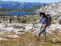
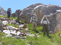
On Sunday, we started the cross country route in earnest. First with a climb up the ridge
to the North East of Grouse Lake. The group made good time cresting the ridge. We did get
a little separated on the decent into the upper Granite basin area, but quickly reassembled
in a wonderful high meadow below Goat Ridge pass.
The first part of the route is long and relative hot until you reach the higher elevations.
It took quite a bit to get to Grouse Lake that day given the amount of climbing even with
just day packs. Because we quickly transitioned from the oxygen rich lower elevations to
the thin air over 10,000 feet, the effect of altitude sickness can be nauseating. Both Kat
and Brian had the familiar nausea and loss of appetite that comes with a quick transition.
Luckily, a good night sleep and the promise of no more 5,000 climbs mostly cured them.
On Sunday, we started the cross country route in earnest. First with a climb up the ridge
to the North East of Grouse Lake. The group made good time cresting the ridge. We did get
a little separated on the decent into the upper Granite basin area, but quickly reassembled
in a wonderful high meadow below Goat Ridge pass.
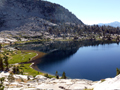
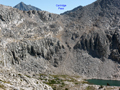
 The Goat Ridge Pass is a classic cross country pass sitting nicely between two ridgelines.
The tarn on the pass is some of the cleanest clear water to be found anywhere. Most of us
took this opportunity refill water bottles without a filter and drink the cold clean
refreshing water. We lunched just on the other side of the pass with views to the North
and the first Glacier Lake well below us. After that, we quickly and easily made it down
to the second lake from the pass and decided it would be a nice place to camp. The lake
was beautiful with jagged black and brown rock rising right from the lake. It was so nice
to swim in and it had a sandy beach on the far side.
The Goat Ridge Pass is a classic cross country pass sitting nicely between two ridgelines.
The tarn on the pass is some of the cleanest clear water to be found anywhere. Most of us
took this opportunity refill water bottles without a filter and drink the cold clean
refreshing water. We lunched just on the other side of the pass with views to the North
and the first Glacier Lake well below us. After that, we quickly and easily made it down
to the second lake from the pass and decided it would be a nice place to camp. The lake
was beautiful with jagged black and brown rock rising right from the lake. It was so nice
to swim in and it had a sandy beach on the far side.
 It was relatively early when we stopped, so we had plenty of time for resting, swimming
and enjoying each other's company.
We did wonder why more people were not around to enjoy such a great lake until we started
hiking again the next morning. From the map, it was not completely evident that we would
encounter slab rock and cliffs the next morning.
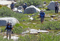
It took some rock climbing skills and
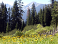
investigating a couple dead ends to find the route down to the meadow below. The meadow
below was expansive and beautiful. We had to maneuver around some boggy areas, but quickly
became reunited with an actual trail.
It was relatively early when we stopped, so we had plenty of time for resting, swimming
and enjoying each other's company.
We did wonder why more people were not around to enjoy such a great lake until we started
hiking again the next morning. From the map, it was not completely evident that we would
encounter slab rock and cliffs the next morning.
It took some rock climbing skills and
investigating a couple dead ends to find the route down to the meadow below. The meadow
below was expansive and beautiful. We had to maneuver around some boggy areas, but quickly
became reunited with an actual trail.
 We made it to the State Lakes trail shortly after the meadow and made our ascent to
State Lakes. The first of the State Lakes was quite inviting. We stopped for a snack
and Reiner and May took a dip in the lake to cool off. We soon found our way to the second
State Lake and stopped for another exploratory of the lake.
After leaving State, the navigation got a bit complicated. A trail was shown on the maps
that was supposed to lead to Horseshoe Lakes, but we started descending too far down to
the West, instead of the North. At one point, we decided to just climb the steep ridge in
the direction of Horseshoe Lakes. Wandering through wooded country can be quite confusing
without land references that are more evident above tree line. Finally after many ups and
steep downs we made it to Horseshoe Lakes. Our destination for the day was a tarn on
Windy Pass Ridge. After leaving Horseshoe Lakes, we finally were able to attend the ridge
that led up to our camp on the ridge.
We made it to the State Lakes trail shortly after the meadow and made our ascent to
State Lakes. The first of the State Lakes was quite inviting. We stopped for a snack
and Reiner and May took a dip in the lake to cool off. We soon found our way to the second
State Lake and stopped for another exploratory of the lake.
After leaving State, the navigation got a bit complicated. A trail was shown on the maps
that was supposed to lead to Horseshoe Lakes, but we started descending too far down to
the West, instead of the North. At one point, we decided to just climb the steep ridge in
the direction of Horseshoe Lakes. Wandering through wooded country can be quite confusing
without land references that are more evident above tree line. Finally after many ups and
steep downs we made it to Horseshoe Lakes. Our destination for the day was a tarn on
Windy Pass Ridge. After leaving Horseshoe Lakes, we finally were able to attend the ridge
that led up to our camp on the ridge.
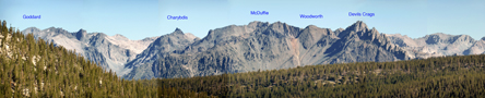
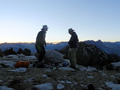
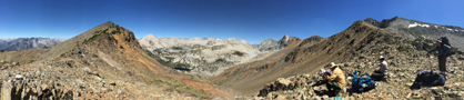
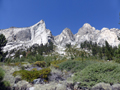
 The tarn is not too impressive for swimming or ultra clean water, but it did provide the
best campsite for viewing a large area of the Sierras. From our camp, you could see all
the way to the Palisades and the Black Divide including Goddard, Charybdis, McDuffie,
Woodward and Devils Crag. Luckily, the ridge did not live up to its name as being windy.
It was actually quite pleasant at this exposed campsite.
The tarn is not too impressive for swimming or ultra clean water, but it did provide the
best campsite for viewing a large area of the Sierras. From our camp, you could see all
the way to the Palisades and the Black Divide including Goddard, Charybdis, McDuffie,
Woodward and Devils Crag. Luckily, the ridge did not live up to its name as being windy.
It was actually quite pleasant at this exposed campsite.
 The next day was a big day for passes, we had three passes that day to commemorate Kat's
birthday. After breaking camp, we descended steadily to the canyon to the North East. We
got a bit separated again with Stan and me dropping to the canyon and the rest taking a
more circler route to the next pass. The canyon was quite beautiful and remote. At one
point, we passed a wonderful hanging lake with outstanding views. A great place to spend
a day, week or month.
The next day was a big day for passes, we had three passes that day to commemorate Kat's
birthday. After breaking camp, we descended steadily to the canyon to the North East. We
got a bit separated again with Stan and me dropping to the canyon and the rest taking a
more circler route to the next pass. The canyon was quite beautiful and remote. At one
point, we passed a wonderful hanging lake with outstanding views. A great place to spend
a day, week or month.
 Before reaching the first pass, we all reunited. It turns out the first pass was only a
dip on the way to a higher pass. Reiner led the way to the higher pass notch to the left
side of the ridge. We lunched on that pass with views to the North and an obvious mound
of red rock and dirt that we determined was Red Cone on the map and the right shoulder
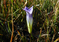
was our last pass of the day. We picked our way down a series of ledges to the lush green
grass between the two passes. One plant had tuffs that looked like hair intertwined with
the grass and spongy moss. Red Cone pass looked steep and high from below, but provided a
quick and easy ascent to the top. The other side views were fabulous stretching from
Marion Lake below into the Lakes Basin area above. Each Lake a step above the other
until the eye reaches the very scenic upper part of Lakes Basin.
Before reaching the first pass, we all reunited. It turns out the first pass was only a
dip on the way to a higher pass. Reiner led the way to the higher pass notch to the left
side of the ridge. We lunched on that pass with views to the North and an obvious mound
of red rock and dirt that we determined was Red Cone on the map and the right shoulder
was our last pass of the day. We picked our way down a series of ledges to the lush green
grass between the two passes. One plant had tuffs that looked like hair intertwined with
the grass and spongy moss. Red Cone pass looked steep and high from below, but provided a
quick and easy ascent to the top. The other side views were fabulous stretching from
Marion Lake below into the Lakes Basin area above. Each Lake a step above the other
until the eye reaches the very scenic upper part of Lakes Basin.

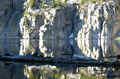
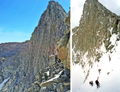
 Getting down to Marion Lake was relatively easy and tedious at first. Most of the route
has a use trail that made the going fast. However, some of the use trail was covered in
deep grass with hidden holes that made the going sloppy and slower. When you reached the
lip overlooking Marion Lake, there appeared to be no way down from the Cliffs. One of the
reasons why Marion Lake is so beautiful. Upon further exploration we found a steep ramp
to the far left of the lake that provided a route down to the lake. The top of the route
is somewhat ominous as it looks like it cliffs out from the top, but after dropping into
the chute, the trail is clear.
Getting down to Marion Lake was relatively easy and tedious at first. Most of the route
has a use trail that made the going fast. However, some of the use trail was covered in
deep grass with hidden holes that made the going sloppy and slower. When you reached the
lip overlooking Marion Lake, there appeared to be no way down from the Cliffs. One of the
reasons why Marion Lake is so beautiful. Upon further exploration we found a steep ramp
to the far left of the lake that provided a route down to the lake. The top of the route
is somewhat ominous as it looks like it cliffs out from the top, but after dropping into
the chute, the trail is clear.
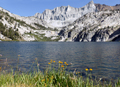
 Once we arrived down at Marion Lake, we stopped and paid homage to the memory of Helen
Marion LeConte, whose name is printed on a rock on the western shore of the lake. Joseph
and Helen Marion honeymooned on the lake over 100 years ago. It truly is a beautiful lake
and worthy of such honor.
Once we arrived down at Marion Lake, we stopped and paid homage to the memory of Helen
Marion LeConte, whose name is printed on a rock on the western shore of the lake. Joseph
and Helen Marion honeymooned on the lake over 100 years ago. It truly is a beautiful lake
and worthy of such honor.
After a long day, some of us got the courage to swim in the cold waters of the lake before
the last ray of sunshine on the lake. Lucky for us, the campsite faced a sheer drop-off
from the west, so we enjoyed sunshine well into dinner.
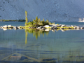
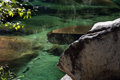
After two long cross country days, we were convinced to have an easy day by strolling to
the upper part of Lakes Basin. On the way, we passed this small pond next to a large moraine.
It had very large trout in plain view from the trail. This place is so remote the fish
have been allowed to grow and thrive.
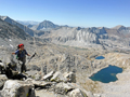
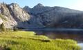
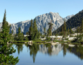
 We took our time going from lake to lake in Lakes Basin. The next stop was a V shaped
lake that we stopped and enjoyed a swim and the start of the fabulous Cirques in
Lakes Basin. Eventually, we arrived at the most upper lake in Lakes Basin near
Cartridge Pass. This upper part of Lakes is perhaps the most beautiful and captivating
part of the route. The Cirque circles like cathedral walls on three side with the vast
expanse to the west. The lakes look like a continuous lines hanging over the basins below.
We took our time going from lake to lake in Lakes Basin. The next stop was a V shaped
lake that we stopped and enjoyed a swim and the start of the fabulous Cirques in
Lakes Basin. Eventually, we arrived at the most upper lake in Lakes Basin near
Cartridge Pass. This upper part of Lakes is perhaps the most beautiful and captivating
part of the route. The Cirque circles like cathedral walls on three side with the vast
expanse to the west. The lakes look like a continuous lines hanging over the basins below.
 After setting up camp and eating lunch, Reiner took most of us on a hike towards
Frozen Lake pass and a better look at Lakes Basin. From up above, Lakes Basin is spotted
with little lakes and ponds. The upper creeks have ultra-clear water and nice grassy
parameters. You could just drink right from the creek. After the hike we made it back to
camp and a fabulous happy hour in this awe inspiring place watching the sunset to the west.
The next morning, Reiner and May got an early start going up and over Frozen Lake Pass.
The rest of the group opted for the easier Cartridge Pass with a much later start.
Cartridge Pass was relatively easy to climb. However, the decent down the other side was
much harder than anticipated. One had to pick the route carefully from the top so as not
to be in an area that was sliding. The Lake below the pass is quite majestic. Bench Lake
was clearly visible from above this lake. So much so that it looked like an easy walk to
the lake. However, there was a deep river valley in between. At this point, Brian was
suffering from exposure to the sun on his skin and was anxious to get some healing
ointments. After the Lake we dropped steeply into the river canyon below. This part of
the trail is so steep, it's a wonder that anyone would want to come up it.
After setting up camp and eating lunch, Reiner took most of us on a hike towards
Frozen Lake pass and a better look at Lakes Basin. From up above, Lakes Basin is spotted
with little lakes and ponds. The upper creeks have ultra-clear water and nice grassy
parameters. You could just drink right from the creek. After the hike we made it back to
camp and a fabulous happy hour in this awe inspiring place watching the sunset to the west.
The next morning, Reiner and May got an early start going up and over Frozen Lake Pass.
The rest of the group opted for the easier Cartridge Pass with a much later start.
Cartridge Pass was relatively easy to climb. However, the decent down the other side was
much harder than anticipated. One had to pick the route carefully from the top so as not
to be in an area that was sliding. The Lake below the pass is quite majestic. Bench Lake
was clearly visible from above this lake. So much so that it looked like an easy walk to
the lake. However, there was a deep river valley in between. At this point, Brian was
suffering from exposure to the sun on his skin and was anxious to get some healing
ointments. After the Lake we dropped steeply into the river canyon below. This part of
the trail is so steep, it's a wonder that anyone would want to come up it.
 Lakes Basin used to be part of the John Muir Trail. In 1938, that agency completed the
John Muir Trail when it built the Golden Staircase (Palisade Creek) and Mather Pass trail
segments. This closed off the Cartridge Pass to the JMT traffic. Lucky for us, as this
basin is well preserved. Once we got down to the River valley below Cartridge Pass, we
still had to pick our way through a constantly disappearing trail and lots of wood fall
to reach the JMT. At this point, Sung, Ken and Brian were intent on getting out a day
early and we decided to split as a group. It was just Stan, Kat and I as Reiner and May
were still by themselves. We agreed that morning to meet for a camp at Bench Lake.
Bench Lake is a bit off the trail, so for Sung, Ken and Brian, it would make it harder
to get out soon.
We finally arrived at Bench Lake about 6pm tired and glad to be stopping. We found a
place with good exposure to the West, so we could have some sun for dinner. We did not
see Reiner or May, so presumed they could not make it in. Bench Lake is a lovely lake and
because it's well off the JMT, not crowded. The JMT is a super highway.
Lakes Basin used to be part of the John Muir Trail. In 1938, that agency completed the
John Muir Trail when it built the Golden Staircase (Palisade Creek) and Mather Pass trail
segments. This closed off the Cartridge Pass to the JMT traffic. Lucky for us, as this
basin is well preserved. Once we got down to the River valley below Cartridge Pass, we
still had to pick our way through a constantly disappearing trail and lots of wood fall
to reach the JMT. At this point, Sung, Ken and Brian were intent on getting out a day
early and we decided to split as a group. It was just Stan, Kat and I as Reiner and May
were still by themselves. We agreed that morning to meet for a camp at Bench Lake.
Bench Lake is a bit off the trail, so for Sung, Ken and Brian, it would make it harder
to get out soon.
We finally arrived at Bench Lake about 6pm tired and glad to be stopping. We found a
place with good exposure to the West, so we could have some sun for dinner. We did not
see Reiner or May, so presumed they could not make it in. Bench Lake is a lovely lake and
because it's well off the JMT, not crowded. The JMT is a super highway.
The next morning, as we were cooking breakfast, Reiner and May made it to our camp.
It was good to be together again even though there were five of us now. After packing up,
we gradually made our way back to the JMT and Pinchot Pass. We met this wonderful family
from Washington State traveling with their boys. The mother took every opportunity to jump
in the lakes along the way inspiring Reiner and May to do the same.
 We finally made it to Pinchot Pass in the afternoon. Much longer climb than previously
thought. After all, it is above 12,000 feet and the highest point along the route
(with the exception of Frozen Lake Pass for Reiner and May). The pass was like a party with
several groups sitting on top. A culture shock after days of seeing no one else.
After lunch, we made our way down to Twin Lakes taking a cross country route for the
last mile. It would be the last lake on our route. The sun exited rather early at Twin.
We finally made it to Pinchot Pass in the afternoon. Much longer climb than previously
thought. After all, it is above 12,000 feet and the highest point along the route
(with the exception of Frozen Lake Pass for Reiner and May). The pass was like a party with
several groups sitting on top. A culture shock after days of seeing no one else.
After lunch, we made our way down to Twin Lakes taking a cross country route for the
last mile. It would be the last lake on our route. The sun exited rather early at Twin.
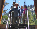
The next morning, Reiner led a cross country route back to the JMT. We followed beautiful
Woods Creek down to the suspense bridge that crosses the tributary of Woods and the
Rae Lakes basin. Some of us crossed the bridge (even though it was not on our route) and
tried to get it to sway. After lunch and bridge play we hiked all the way to the first
part of Paradise Valley. At around 7,500 feet, it was our first campsite of the trip
below 10,000. The warm night was a welcome feel to the colder nights up high that usually
meant an early bedtime.
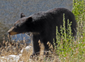
 The last day was a relatively easy 9.5 miles out to Road's End. Along the way the river
meandered past enormous boulders and tree falls. There were spectacular waterfalls and
inviting places to swim. We did pass a mother bear and its cub being careful not to get
too close.
The last day was a relatively easy 9.5 miles out to Road's End. Along the way the river
meandered past enormous boulders and tree falls. There were spectacular waterfalls and
inviting places to swim. We did pass a mother bear and its cub being careful not to get
too close.
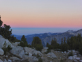
 We finally got back to the cars about 11:30am. The weather for the trip was the best.
It was sunny everyday with little wind. On a rare occasion we would see a cloud. The night
skies were amazing with the Milky Way clearly visible. The later part of the trip coincided
with the peak of the Perseids meteor shower, so shooting stars were visible in great
frequency.
We finally got back to the cars about 11:30am. The weather for the trip was the best.
It was sunny everyday with little wind. On a rare occasion we would see a cloud. The night
skies were amazing with the Milky Way clearly visible. The later part of the trip coincided
with the peak of the Perseids meteor shower, so shooting stars were visible in great
frequency.
It was a great trip with wonderful friends. Thanks to Reiner for his sage advice and
navigation skills. Thanks to all for making the trip possible and for the good humor
during sometimes difficult days.