

 There were several reasons for this summer peak climbing trip: To finish the SPS List, which has now grown to 248 peaks, to honor my alma mater, to add another unlisted peak to my SPS extension list and, frankly speaking, the old habit of peak climbing.
 I left L.A. on mid Friday, 7/18, and got a wilderness permit in Lone Pine at 4pm. The young ranger asked me whether I really wanted to do Shepherd Pass in mid-summer when it was 102 deg. outside. My plan was to go at night and in the morning. After torturing my Prius over the 4WD road to the Symmes Creek trailhead I started after 5pm and hiked for 3 hours until the full moon rose. Then I spent the night on the 9000' saddle on top of the arduous switchbacks before the trail drops down into the Shepherd Creek valley.
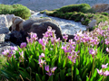
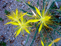
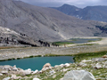
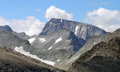
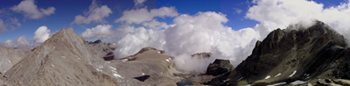
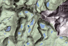
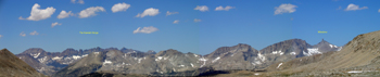
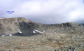 Sat, 7/19, I continued at sunrise and hiked past Anvil Camp up to the 12,000' Shepherd Pass, which was reached by 10:30am. In the high country it was pleasantly cool with a steady breeze. It felt good to have finished the first 6000' climb. My plan was to head to the Tyndall Creek and find a nice lake near Caltech Peak southwest of Forrester Pass. I hiked XC around the south end of Diamond Mesa and stopped by some of the unnamed lakes. All along there was a fine view of the Kaweahs and the Grest Western Divide. Summer clouds were in the sky and abundant wildflowers were in bloom. The Sierra showed its best side.
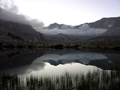
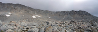
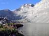
 I followed Tyndall Creek and a short section of the John Muir trail to an unnamed pair of lakes about 1 mi southeast of Caltech Pk at 3700 m which had some campsites among the rocks. It was too windy and cool for a swim. More and more clouds covered the sky. I inspected my ascent route via the east ridge to the summit. Everything looked straightforward and I settled confidently for the night.

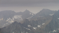
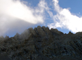
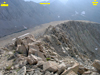
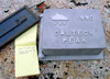
 Sun morning, 7/20, I could not believe my eyes: Dark clouds hung over the mountains and it looked like summer was over. I left at 6am, ascended over the east ridge which had some nice class 3 sections, and reached the flattish plateau with a trivial hike to the 13,832' summit which was reached at 8am. The famous summit views were disappointing since most of the higher peaks were in the clouds and rain seemed imminent. The 1990 SRC register can was empty, but in the rocks below there was a new ammo box with a spiral notebook from 2007, claiming the register was removed by a 2006 Brewer SAR action. Too bad, since I was interested to perhaps find the names of some "Techers" from my times at Caltech (MS '65, PhD '70). A bit of history about the peak, early register and a now missing commemorative plaque can be found in a 1991 trip report by Prof. Brennen.
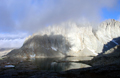
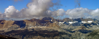
 More recent history took place in the Sierra Peaks Section where several attempts were made to add the peak to the SPS List. Since a number of Techers were prominent SPS Leaders, the peak was finally added in 2007, largely in memory of Duane McRuer. So far, the only entries by SPS members can be found on a loose sheet from 6/2/2007. But it was fun to sign the register now with # 248, having again "finished" the List. In spite of the gloomy skies there were Kodak moments which one cannot get on a typical sunny Sierra day. It was gloomy with some rays of light: Patches of sunlight broke through the clouds and illuminated the jagged ridge of Ericsson and the Kings-Kern Divide. At times prominent Milestone Mtn poked through the clouds. When the first raindrops fell I descended along the east ridge, taking a short cut down on the steeper south wall. Luckily, the rain did not continue for too long.
 By mid morning I broke camp and hiked out along the JMT, direction Wright Lakes. The plan was to climb Mt Versteeg, an unlisted and rarely climbed but challenging peak south of Mt Tyndall. The usual easier route is from Williamson Bowl, but this terrain is closed in the summer to protect the Bighorn sheep. The alternative is from the west out of the Wright Lakes Basin. The shortest route from Tyndall Creek is over the saddle at 378E, 4056400N, which has a faint use trail though scree and talus.
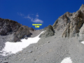
 On Mon morning, 7/21, low clouds were hanging around but the peaks were clear. I figured the upcoming sun would burn off the clouds and optimistically took off. I hiked up Wright Creek toward the highest Lake 3645 m just west of Versteeg. Arriving at 7am the clouds beat me. From all sides they were descending and covering the peaks. At the base of Versteeg I could not even see the talus fan which led into the sandy chute to the ridge. This was Murphy's law at its best: whatever can go wrong does go wrong. I set down and had another breakfast hoping for some miracle. After half an hour something happened. The clouds got thinner and patches of blue sky appeared. I waited longer to see whether this would be true. By 8 am I started the ascent.
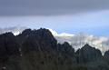
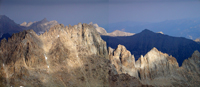
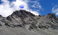
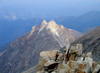
 Following RJ's description one climbs a sandy chute to the south of the summit and below the ridge one switches to a steeper chute to the north of the summit to climb the peak. Sounds straightforward but not when you stand in front of a mountain with half a dozen of similar chutes separated by pillars all of which look like the high point. Predictably, my first chute did not go. The second one did go but was not the right one since it had some 4'th class moves. But once on the ridge it became easier class 3 climbing from one pillar to the next. Finally, I reached the high point, the southeastern most pillar (13,470'). At 10 am I was delighted to find an ammo box with a register below a summit cairn. This was an exciting climb!
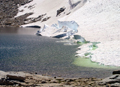
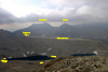
 Although not the highest point in the area, the climb and view were far more interesting that that of Caltech Peak which is just a high point on a ridge. Versteeg is in an Alpine surrounding of big, rugged peaks like Williamson and Tyndall. Helen-of-Troy Lake was partly filled with ice and snow. Clouds from the Nevada cutoff low were swirling around the peaks. In the west it had cleared up and all the peaks of the Kaweahs and Great Western Divide were visible. To the south Mt Whitney poked out of the clouds. With my camera, which is better than my eyes, the summit house is even visible. The register must have suffered the fate of many "lost" ones. A loose sheet with a map was placed by Bob Burd on 6/26/2004 on which all subsequent climbers signed till a spiral notebook was started in 2006. There are few visitors on this peak. A few parties in '04, none in '05, three in '06, one "bird" in '07, and so far myself in '08. No familiar SPS or SMS names are to be found, yet Chester Versteeg was a prominent Sierra Club officer and a mountaineer like Norman Clyde.
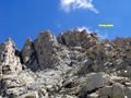
 On the descent the correct chute became much clearer. The first chute below the summit is class 3, as correctly stated. The catch is that the summit is hidden from below. There is a sharp needle on the true summit and the correct chute is just below this "aiguille de Versteeg". On the climb down the sandy chute splits and one has to keep to the right since the left leads into a vertical drop rather than the talus fan. By midday I was back down at Lake 3645m and ready for my dip in bright sunshine. What a difference half a day makes!
Then I returned to camp, packed up and retraced my way back over Tyndall-Wright Pass and Shepherd Pass. At 5 pm I was at Anvil Camp and called it quits.
On the descent the correct chute became much clearer. The first chute below the summit is class 3, as correctly stated. The catch is that the summit is hidden from below. There is a sharp needle on the true summit and the correct chute is just below this "aiguille de Versteeg". On the climb down the sandy chute splits and one has to keep to the right since the left leads into a vertical drop rather than the talus fan. By midday I was back down at Lake 3645m and ready for my dip in bright sunshine. What a difference half a day makes!
Then I returned to camp, packed up and retraced my way back over Tyndall-Wright Pass and Shepherd Pass. At 5 pm I was at Anvil Camp and called it quits.
 Tue morning,7/22, I hiked the remaining 4000' down the Shepherd Pass trail. More precisely, this includes a 600' uphill section. By 10:30am I was back at the car and felt the heat building up. There was not a cloud in the sky. The Sierra was so refreshing and always has somes surprises.
P.S. Some extra pictures requested are added below:
|
|
|
|
|
|
|
|
|
Back to Trip Reports
Back to SMS Home Page