
There are many ways to enjoy the mountains. Our section likes to ski them, the peak climbers like to climb them, and there are some who like to hike among them on long distance trails. In this country the famous long distance trails are the Appalachian Trail (AT) and the Pacific Crest Trail (PCT). To get the flavor of thru-hiking you can do sections of them. One of the nicest section of the PCT is the John Muir Trail (JMT) which I hiked 10 years ago ( Hiking the John Muir Trail). Perhaps the best part of the AT is in the Smoky Mountains which I experienced earlier this year ( Hiking on the AT). This private trip report may stimulate some SMSrs to try something similar. It is also fun to visit similar areas in winter and summer.
Thru-hiking is also common in Europe where there are about a dozen long distance trails criss-crossing the continent. A most attractive trail is the European Hiking trail E5 which goes from the Atlantic (Brittany) to the Mediterranean (Venice). Its best portion crosses the Alps from Germany through Austria to Italy. For several years my older brother Juergen suggested to do this trans-Alpine hike together and this year we finally did it.
Hiking the E5 across the Alps is not the same as hiking the JMT through the Sierras. The latter is predominantly a wilderness experience. Hiking through the Alps is a sampling of many experiences: Steep mountains with unpredictable weather, comfortable accomodations and food in mountain huts or inns in the valleys. Thus, your pack is lighter, but your wallet has to be heavier. The trail is usually well marked but errors are possible due to a multitude of other trails. The trail typically goes from one river valley to the next over steep mountain ranges, such that you are exposed to the contrasts between the rugged high country and the developed valleys. Some passes involve rock and snow climbing, no glacier travel is involved, some sections are protected by steel ropes, and some trails are on 60+deg slopes where a slip is fatal. In bad weather one may have to change one's plans but in late summer, like our Indian summer, the weather is mostly stable. You meet many people and have fun, the scenery is gorgeous, there is history and culture everywhere. What you loose in wilderness experience you gain in human experience. Now a more detailed description with pictures:
On Friday, Sep 1, we took a train to Oberstdorf, a small town in the
Allgau Alps in Bavaria, Germany. In the afternoon we left the tourist town and
hiked south along the river "Trettach" past a pretty lake "Christlessee", the
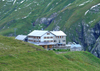
last settlement "Spielmannsau" up a steep trail to the "Kemptener Huette", a
well-established mountain hut of the German Alpine Club.
 The afternoon hike took about 5 hours for the 8mi, 3600' climb. The weather was
hot and humid. The lower valleys and slopes were filled with wildflowers.
Eventually, the terrain became rocky ant at 6200' we reached the snow which had
fallen in the previous week.
The afternoon hike took about 5 hours for the 8mi, 3600' climb. The weather was
hot and humid. The lower valleys and slopes were filled with wildflowers.
Eventually, the terrain became rocky ant at 6200' we reached the snow which had
fallen in the previous week.
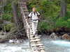
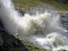
 The trail crossed the gushing creek "Sperrbach" on a small bridge. Steelropes
were fixed along the trail when a gushing creek crossed the trail over slippery
limestone. Finally, we saw the hut on a grassy plateau. The Kemptner Huette is a
solid brick building providing accomodation (small rooms or bunkbeds), clean
bathrooms, hot showers, food, drinks and a comfortable dining room for many
guests.
The trail crossed the gushing creek "Sperrbach" on a small bridge. Steelropes
were fixed along the trail when a gushing creek crossed the trail over slippery
limestone. Finally, we saw the hut on a grassy plateau. The Kemptner Huette is a
solid brick building providing accomodation (small rooms or bunkbeds), clean
bathrooms, hot showers, food, drinks and a comfortable dining room for many
guests.
 The hut is owned by the Alpine Club, has a hut manager and staff, reasonable
prices and a policy of accomodating every hiker since outdoors camping is
neither allowed nor custom. Prices are reasonable, especially for members of the
Alpine Club or other recognized climbing organizations (such as the Sierra
Club).
The hut is owned by the Alpine Club, has a hut manager and staff, reasonable
prices and a policy of accomodating every hiker since outdoors camping is
neither allowed nor custom. Prices are reasonable, especially for members of the
Alpine Club or other recognized climbing organizations (such as the Sierra
Club).
 There are many many hut rules (no boots inside rooms, quiet at 10pm, leave by
8am, bring own sheets, fold blankets, etc) but many pleasures (dinner and drinks
for purchase, warm blankets, hot showers, comfortable living room with maps,
information, etc). The hut is also a place for socializing since meeting the
same E5 hikers forms friendship and cameraderie. Breakfast is included in the
hut price and one can buy some more ingredients for a sack lunch. Typically we
were on the trail by 7:30am.
There are many many hut rules (no boots inside rooms, quiet at 10pm, leave by
8am, bring own sheets, fold blankets, etc) but many pleasures (dinner and drinks
for purchase, warm blankets, hot showers, comfortable living room with maps,
information, etc). The hut is also a place for socializing since meeting the
same E5 hikers forms friendship and cameraderie. Breakfast is included in the
hut price and one can buy some more ingredients for a sack lunch. Typically we
were on the trail by 7:30am.
On Sat, Sep 2, we hiked from the Kemptener Huette to a pass called
"Maedelejoch" (1974m = 6510'). It forms the border between Germany and Austria
which is more of historic interest than present importance in the European
Union. There was patchy snow on the trail but it posed no problems. From the
pass we descended 3000' down to the town of Holzgau on the river Lech. There is
an established cab driver (Feuerstein) who takes groups of E5 hikers who do not
want to walk along the 23km road to the next trailhead. So we got a ride along
the valley of the Lech and Madau up a private road to the starting point where
one ascends to the Memminger Huette.
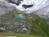
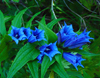
 This is a short but steep climb (4310'). The hut is supplied with a cargo lift
and against a small fee one can get the backpacks pulled up. In spite of this
European decadence, it was a hot and sweaty climb. But there were pretty flowers
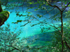
along the way and sweet rasberries to eat. The Memminger hut (7400') is located
on a grassy plateau among steep mountains, a green lake and an easily climbed
peak (Seekogel, 7960') with great views over many other peaks. Dark clouds
rolled in and it started to rain by 6pm.
This is a short but steep climb (4310'). The hut is supplied with a cargo lift
and against a small fee one can get the backpacks pulled up. In spite of this
European decadence, it was a hot and sweaty climb. But there were pretty flowers
along the way and sweet rasberries to eat. The Memminger hut (7400') is located
on a grassy plateau among steep mountains, a green lake and an easily climbed
peak (Seekogel, 7960') with great views over many other peaks. Dark clouds
rolled in and it started to rain by 6pm.
Sun, Sep 3. We got up at 6am and hiked out at 7:30am in a light rain.
What happened to the Indian summer? The snow-covered trail ascended 1200' to a
pass "Seescharte".
 It was a cl 2-3 hike in inclemental weather. The south side was free of snow but
involved a steep 6000' descent into the next valley to the town of Zams at the
river Inn. On the way we stopped at a mountain restaurant for some refreshments.
It was a cl 2-3 hike in inclemental weather. The south side was free of snow but
involved a steep 6000' descent into the next valley to the town of Zams at the
river Inn. On the way we stopped at a mountain restaurant for some refreshments.
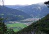
 The trail descended along the steep slopes of the river "Lochbach". As we got
lower the town of Landeck and the green, meandering river Inn became visible.
Finally, we arrived in the town of Zams in a green valley with many orchards and
fine homes, many of which advertised "Zimmer frei", i.e. comfortable
accomodations at reasonable rates. We ate in town where we met our familiar E5
through-hikers and shared with them our stories of the day over a glass of beer.
The trail descended along the steep slopes of the river "Lochbach". As we got
lower the town of Landeck and the green, meandering river Inn became visible.
Finally, we arrived in the town of Zams in a green valley with many orchards and
fine homes, many of which advertised "Zimmer frei", i.e. comfortable
accomodations at reasonable rates. We ate in town where we met our familiar E5
through-hikers and shared with them our stories of the day over a glass of beer.
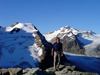
Labor Day, Sep 4. After a good breakfast we headed to the "Venetbahn"
(the local ski gondola) to get the first ride up to the "Krahberg".
 In 8 min we climbed 4600' which would have taken us several hours on foot. Once
on the plateau above the Inn valley we started to hike up to the "Kreuzjoch"
(8240'). There was a spectacular view over the panorama of the mountains near
the Inntal, Pitztal, Oetztal, and Kaunertal.
In 8 min we climbed 4600' which would have taken us several hours on foot. Once
on the plateau above the Inn valley we started to hike up to the "Kreuzjoch"
(8240'). There was a spectacular view over the panorama of the mountains near
the Inntal, Pitztal, Oetztal, and Kaunertal.
![]() The weather began to clear. We continued along the mountain ridge, then
descended on wide open slopes into the next valley toward the town of Wenns. The
south-facing slopes were covered with blooming heather, blueberries and Preissel
berries. The leaves turned red in the early autumn sun.
The weather began to clear. We continued along the mountain ridge, then
descended on wide open slopes into the next valley toward the town of Wenns. The
south-facing slopes were covered with blooming heather, blueberries and Preissel
berries. The leaves turned red in the early autumn sun.
Travel along the river valleys is done by most E5 hikers by hired or public
transportation.
 Only purists walk the 30km stretch along the road to the trailhead for the next
hut, the Braunschweiger Huette. We joined a group of guided hikers, paid our
dues and got a ride through the beautiful Pitztal from Wenns via St Leonhard to
Mittelberg at the end of the Pitztal. Near the trailhead there was again a cargo
lift which took our packs to the Braunschweiger hut. We hiked up the steep trail
next to the river Pitze which is a powerful stream originating from the melting
glaciers in the high country. The grey-green water forms several impressive
waterfalls on its way into the valley.
Only purists walk the 30km stretch along the road to the trailhead for the next
hut, the Braunschweiger Huette. We joined a group of guided hikers, paid our
dues and got a ride through the beautiful Pitztal from Wenns via St Leonhard to
Mittelberg at the end of the Pitztal. Near the trailhead there was again a cargo
lift which took our packs to the Braunschweiger hut. We hiked up the steep trail
next to the river Pitze which is a powerful stream originating from the melting
glaciers in the high country. The grey-green water forms several impressive
waterfalls on its way into the valley.
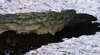
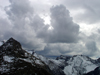
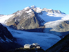 After many switch-backs one can see the grey-blue tongue of the glacier.
According to older observers it has greatly receded. The 2hr, 3400' climb to the
Braunschweiger hut was again steep and sweaty. The location of the hut among
several glaciers and peaks, such as the Wildspitze, Oetztal's highest one, was impressive. In
the distance one could see many ski lifts for controversial summer skiing on
the glaciers. The high country between the Oetztal and Pitztal is a highly
developed ski area.
After many switch-backs one can see the grey-blue tongue of the glacier.
According to older observers it has greatly receded. The 2hr, 3400' climb to the
Braunschweiger hut was again steep and sweaty. The location of the hut among
several glaciers and peaks, such as the Wildspitze, Oetztal's highest one, was impressive. In
the distance one could see many ski lifts for controversial summer skiing on
the glaciers. The high country between the Oetztal and Pitztal is a highly
developed ski area.
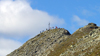
Tue, Sep 5. After the usual 6:30am rise we hiked out an hour later
toward the Pitztaler Joechl, the highest pass on the E5 (9880'). A height
comparison with passes in the Sierra Nevada (13,000' Forrester Pass) is not
appropriate since the Alpine terrain is mostly glaciated above 10,000'.
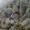
 The ascent to the pass was straightforward but on the east side there was a
sizeable steep snow field. In the morning hours the snow was frozen hard and the
descent without crampons and ice axe was a bit risky. At some places where ice
and rock met a fixed steel cable provided safety. We made it safely down and
continued through talus to the trail along the Rettenbach river, another glacial
stream. The Rettenbachtal is also a highly developed ski and tourist area. Many
ski lifts and related structures are built on the slopes and glaciers above the
town of Soelden.
The ascent to the pass was straightforward but on the east side there was a
sizeable steep snow field. In the morning hours the snow was frozen hard and the
descent without crampons and ice axe was a bit risky. At some places where ice
and rock met a fixed steel cable provided safety. We made it safely down and
continued through talus to the trail along the Rettenbach river, another glacial
stream. The Rettenbachtal is also a highly developed ski and tourist area. Many
ski lifts and related structures are built on the slopes and glaciers above the
town of Soelden.
 The E5 trail luckily stayed high above the busy Oetztal yet one could not avoid
to see the impact of humans on the beautiful mountains. Actually, we benefitted
from one, a pretty Jausenstation at the Loiple Alm, where we had soup and
sandwich for lunch. Then we hiked down to the town of Zwieselstein at the
glacial stream "Venter Ache". Next to it was a hut of the Alpine Club which we
preferrred over the commercial hotels. We took a hot shower, washed clothes,
dined, shopped, met our hiking buddies over a beer and enjoyed the pretty little
mountain town.
The E5 trail luckily stayed high above the busy Oetztal yet one could not avoid
to see the impact of humans on the beautiful mountains. Actually, we benefitted
from one, a pretty Jausenstation at the Loiple Alm, where we had soup and
sandwich for lunch. Then we hiked down to the town of Zwieselstein at the
glacial stream "Venter Ache". Next to it was a hut of the Alpine Club which we
preferrred over the commercial hotels. We took a hot shower, washed clothes,
dined, shopped, met our hiking buddies over a beer and enjoyed the pretty little
mountain town.
Wed, Sep 6. As on previous days, whenever there was a road with
public transportation we took it to get close to the next trailhead, especially
on a long-distance day as this one. We took a public bus via Obergurgl to the
pass "Timmelsjoch" (8280') which is at the border between Austria and Italy.
From there we hiked the E5 toward the Passeiertal. The area must have been of
startegic interest due to various abandoned military buildings.
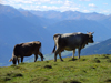
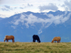
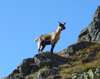 Lots of mountain goats grazed on the upper slopes, cows roamed on the lower
meadows ("Alms"). The hills were colored by red leaves of small bushes. In the
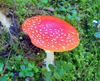
forests below there was an abundance of different mushrooms. After a drop of
nearly 5000' we reached the town of Moos at the Passer river. By sheer luck a
public bus arrived when we reached the town center. It took us to St. Leonhard
in Passeier where we had a lunch break before heading up to the Pfandler Alm
hut. This hike was a 2400' climb through dense forest on a hot afternoon in
99.9999% humidity. The Pfandler Alm is a small private hut, a bit more pricey
than the Alpine Club huts but very elegant and beautiful, located in a green
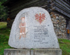
meadow surrounded by forest. Nearby is a simple hut of historic interest:
Andreas Hofer, Tirol's famous freedom fighter against the French and Bavarians,
was caught here and executed in 1809. At the hut the host prepared for all
guests a barbeque dinner with plenty of wine and beer, afterwards someone played
the guitar and we all sang folk songs.
Lots of mountain goats grazed on the upper slopes, cows roamed on the lower
meadows ("Alms"). The hills were colored by red leaves of small bushes. In the
forests below there was an abundance of different mushrooms. After a drop of
nearly 5000' we reached the town of Moos at the Passer river. By sheer luck a
public bus arrived when we reached the town center. It took us to St. Leonhard
in Passeier where we had a lunch break before heading up to the Pfandler Alm
hut. This hike was a 2400' climb through dense forest on a hot afternoon in
99.9999% humidity. The Pfandler Alm is a small private hut, a bit more pricey
than the Alpine Club huts but very elegant and beautiful, located in a green
meadow surrounded by forest. Nearby is a simple hut of historic interest:
Andreas Hofer, Tirol's famous freedom fighter against the French and Bavarians,
was caught here and executed in 1809. At the hut the host prepared for all
guests a barbeque dinner with plenty of wine and beer, afterwards someone played
the guitar and we all sang folk songs.
Thur, Sep 7. It was another long day to make it to the next hut, the
Meraner Huette. We ascended from the Pfandler Alm along forest trails and later
open terrain to the Hirzer Joch.
 Before climbing this pass, we stopped for lunch at another fine Jausenstation,
the Mahdalm, for roast potatoes with eggs. The trail to the pass heads into a
cirque ending in a steep mountain wall, where one wonders how to ascend it.
Before climbing this pass, we stopped for lunch at another fine Jausenstation,
the Mahdalm, for roast potatoes with eggs. The trail to the pass heads into a
cirque ending in a steep mountain wall, where one wonders how to ascend it.
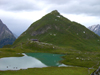
 But there is a cl 3 trail up to the south ridge leading to the Hirzer peak
(9189'), the highest peak of the Sarntaler Alps. The peak was mostly in the
clouds so that an ascent would not have offered the great views promised in
descriptions. We descended over talus fields along the E5 which coincides with a
trail used by the "Gebirgsjaeger", the mountain soldiers. At a pretty lake I had
a refreshing bath. For many hours we contoured around a chain of mountains. The
sky got darker and we heard thunder. By 6pm we reached the Meraner Huette. An
hour later full blown thunderstorm moved in. Rain and lightning lasted well into
the night. We were fortunate not to have this weather on the trail.
But there is a cl 3 trail up to the south ridge leading to the Hirzer peak
(9189'), the highest peak of the Sarntaler Alps. The peak was mostly in the
clouds so that an ascent would not have offered the great views promised in
descriptions. We descended over talus fields along the E5 which coincides with a
trail used by the "Gebirgsjaeger", the mountain soldiers. At a pretty lake I had
a refreshing bath. For many hours we contoured around a chain of mountains. The
sky got darker and we heard thunder. By 6pm we reached the Meraner Huette. An
hour later full blown thunderstorm moved in. Rain and lightning lasted well into
the night. We were fortunate not to have this weather on the trail.
Fri, Sep 8. On a gray morning with light rainfall we headed south on
the E5 toward Bozen (or Bolzano in Italian, which locals don't use). The trail
follows on an open ridge with views on distant mountain ranges. The sky began to
clear. An impressive chain of steep mountains and spires, the Dolomiten,
appeared out of the clouds.
 The cows were driven down from the high alms to the lower meadows, indicating
the change of season. As we reached the treeline we soon found mountain
restaurants again, the nicest of which was near an old church called St. Jakob
at Langfenn. We planned to rent a room in the mountain town Jenesien but all
rooms were booked out since a mountain marathon was scheduled for the next day.
So we decided to take the tram down to Bozen. There we met our group of E5
hikers, stranded because the tram was not running since it was struck by
lighting last night. The next city bus was coming in 3 hours, about the same
time as walking the 10km on the road to Bolzano. We discussed the situation over
a beer when the restaurant owner found a private taxi for us. Well, we were now
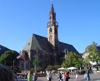
in Italy where things work differently. We spent the last night in the
fashionable town of Bolzano mingling with the many tourists. The next morning we
took a fast train over the Brenner Pass back to Germany.
The cows were driven down from the high alms to the lower meadows, indicating
the change of season. As we reached the treeline we soon found mountain
restaurants again, the nicest of which was near an old church called St. Jakob
at Langfenn. We planned to rent a room in the mountain town Jenesien but all
rooms were booked out since a mountain marathon was scheduled for the next day.
So we decided to take the tram down to Bozen. There we met our group of E5
hikers, stranded because the tram was not running since it was struck by
lighting last night. The next city bus was coming in 3 hours, about the same
time as walking the 10km on the road to Bolzano. We discussed the situation over
a beer when the restaurant owner found a private taxi for us. Well, we were now
in Italy where things work differently. We spent the last night in the
fashionable town of Bolzano mingling with the many tourists. The next morning we
took a fast train over the Brenner Pass back to Germany.
It was an enjoyable trip with many pleasant experiences, not too hard, not
too easy, and a great contrast to skiing the
Alps in winter. For those who like the stats the trail is about 90mi and
25,000'.
Back to Trip Reports
Back to SMS Home Page